Tuesday, December 1, 2020

Another East Coast Storm May Bring More Snow to the Northeast, Ohio Valley, Appalachians

 Jonathan Erdman

Published: December 1, 2020


Another East Coast storm may develop this weekend, potentially bringing more snow to parts of the Northeast, Ohio Valley and Appalachians just hit by a snowstorm early this week.

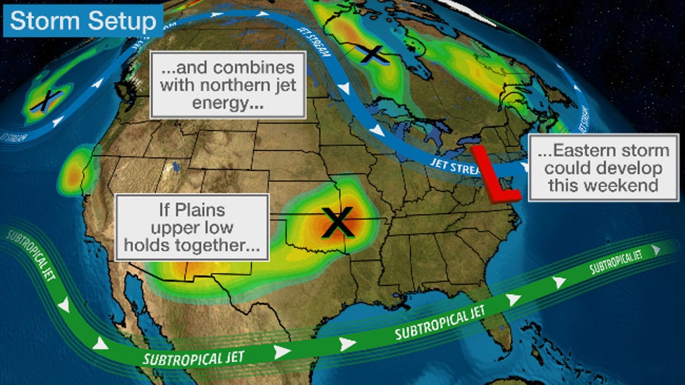
Similar to the storm affecting the East this week, named Winter Storm Dane by The Weather Channel, this potential weekend Eastern storm depends on whether energy from two jet streams can team up.

Namely, a large area of low pressure aloft spinning over the central Plains is expected to eventually be pulled eastward.

If that Plains upper low can remain fairly intact as it tracks east and can team up with disturbances in the northern branch of the jet stream, a strong area of low pressure could again form in the East this weekend.

For now, that's the scenario the majority of computer forecast models are suggesting.

But that's not guaranteed to happen. There are also the typical uncertainties with timing, the track of the Eastern low-pressure system and how much cold air will be available.

For now, we'll lay out our best outlook, but check back frequently for updates over the next few days as the forecast becomes clearer.

First, Plains Snow

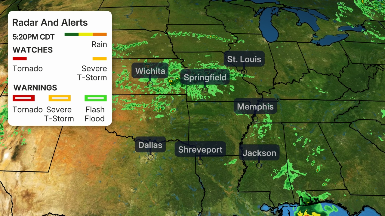
That Plains upper low will first generate a blanket of wet snow over parts of the Plains Wednesday and Wednesday night.

The biggest snow totals – over 6 inches in spots – are expected in parts of northwestern Oklahoma and southern Kansas.

Some lighter accumulations are possible in both the Wichita, Kansas, and Oklahoma City metro areas. This may lead to slick roads – especially bridges and overpasses – Wednesday night and early Thursday.

Friday's Outlook

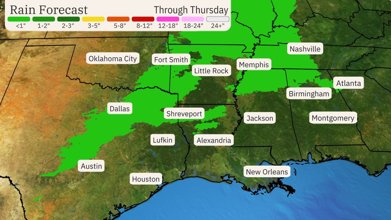
Rain and a few thunderstorms are possible in the Southeast Friday.

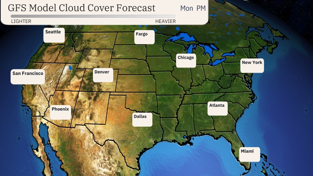
Some precipitation should also spread into parts of the Northeast and Ohio Valley. Where some cold enough air is in place along the northern fringe, that precipitation may fall as snow, as shown in the forecast map below.

Friday's Outlook

Saturday's Outlook

By Saturday, the majority of computer models suggest low pressure will have developed somewhere along the East Coast.

As mentioned earlier, the exact track of the low will be crucial for determining where the rain-snow line will set up.

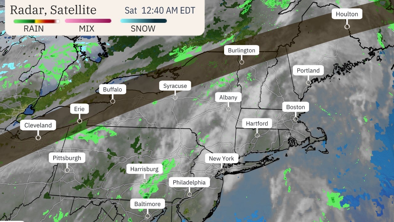
For now, the best chance of snow Saturday stretches from parts of the Ohio Valley and eastern Great Lakes to the Appalachians and interior Northeast.

Closer to the Interstate 95 Northeast urban corridor, precipitation may fall mostly as rain Saturday and Saturday night.

(MORE: Northeast Urban Corridor 'High-Impact Snowstorm' Drought Enters Third Winter)

Saturday's Outlook

Sunday's Outlook

By Sunday, most computer models suggest low pressure will be spinning somewhere near or over New England.

Assuming that happens, the best chance of accumulating snow Sunday and Sunday night is over the interior Northeast, mainly north and west of Interstate 95.

Sunday's Outlook

Again, it's too soon to hone in on precise snow – and rain – total forecasts in the Northeast. Check back for updates in the coming days.

The Weather Company’s primary journalistic mission is to report on breaking weather news, the environment and the importance of science to our lives. This story does not necessarily represent the position of our parent company, IBM.

The Weather Company’s primary journalistic mission is to report on breaking weather news, the environment and the importance of science to our lives. This story does not necessarily represent the position of our parent company, IBM.


Winter Storm Bringing Wind-Driven Snow to Eastern Great Lakes, Appalachians

 weather.com meteorologists

Published: December 1, 2020


December is starting out with a winter storm wringing out wind-driven snowfall in the eastern Great Lakes and Appalachians.

This weather system has been named Winter Storm Dane by The Weather Channel.

Winter storm warnings and winter weather advisories have been issued by the National Weather Service (NWS) from the eastern Great Lakes to the Appalachians. Cleveland, Ohio, and Erie, Pennsylvania are among the cities that are under a winter storm warning, which means travel in these areas could be difficult or impossible at times.

Winter Weather Alerts

The National Weather Service reports that parts of northern Ohio and northwest Pennsylvania have picked up at least 10 inches of snow, including 15 inches near Painesville, Ohio and 10.5 inches near Columbus, Pennsylvania.

some areas on the southeast side of Cleveland have had more than a half-foot of snowfall as of Tuesday morning. Just over a foot of snow was measured near South Thompson, Ohio on Tuesday morning.

Snowfall was less near the immediate shore of Lake Erie as of early Tuesday.

Trees and powerlines have been downed by the heavy snow and strong winds to the east of Cleveland in Geauga County, Ohio, according to the Chardon Fire Department.

Generally 1 to 4 inches of snow has been reported in Detroit, Pittsburgh, Columbus, Cincinnati and Charleston, West Virginia.

Current Radar

This storm brought at least light snow as far south as middle and eastern Tennessee, western North Carolina and northern Georgia on Monday and Monday night. A foot of snow was measured at Roan Mountain, Tennessee, and 15 inches was reported near Robbinsville, North Carolina.

On the immediate Northeast coast, wind-driven rain knocked out power in some areas on Monday and Monday night. More than 100,000 homes and businesses were without power in Maine as of Tuesday morning, according to poweroutage.us.

Forecast

Wind-whipped snow will continue Tuesday night from the eastern Great Lakes into the Appalachians. Heavier snow will fall in bands south or southeast of Lake Erie.

Lingering wraparound snow and lake-effect snow from this storm could linger into Wednesday in western and central New York and northern New England.

Additional snowfall of 6 inches or more is most likely in the Lake Erie snowbelt from northeast Ohio to southwest New York, and also in the Lake Ontario snowbelt of upstate New York. Travel on the Interstate 90 corridor through Cleveland, Erie, Pennsylvania, and areas near and south of Buffalo, New York, could be difficult Tuesday night.

Accumulating snow is also expected in the Appalachians. This could also lead to treacherous travel.

Rain and Snow Forecast

Monday's Storm Recap

Snowfall from this storm on Monday affected many areas from southeast Michigan into parts of Indiana, Ohio, West Virginia, Kentucky and Tennessee. Snow flurries were reported as far south as the Atlanta metro area.

On the storm's warm side, wind gusts over 50 mph have been clocked from the Jersey shore to Long Island and eastern New England. Over 100,000 customers were without power in the Northeast due to the storm, according to PowerOutage.us.

Isolated severe thunderstorms flared up Monday ahead of the cold front in the Mid-Atlantic states, prompting several severe thunderstorm warnings and even tornado warnings.

A brief EF0 tornado caused tree and property damage, as well as shook or tossed several cars, Monday afternoon in Montgomery County in Pennsylvania.

One tornado confirmed by NWS radar apparently crossed from eastern Maryland into western Delaware. Trees were downed, one of which landed on a vehicle in Marydel, Delaware.

Other severe thunderstorms downed numerous large trees in Woodlawn, Maryland, on the west side of the Baltimore metro area.

Some flooding was reported in a few spots from Virginia to New Jersey, but appeared to be fairly localized.

The Weather Company’s primary journalistic mission is to report on breaking weather news, the environment and the importance of science to our lives. This story does not necessarily represent the position of our parent company, IBM.

The Weather Company’s primary journalistic mission is to report on breaking weather news, the environment and the importance of science to our lives. This story does not necessarily represent the position of our parent company, IBM.

Winter Storm Knocks Out Power to Tens of Thousands From Ohio to Maine; Schools Closed

 Ron Brackett

Published: December 1, 2020


A winter storm has forced schools to close, shut down roads and left tens of thousands without power from the Great Lakes to the Eastern Seaboard.

Nearly 63,000 homes and businesses in Ohio had no power as of Tuesday afternoon, according to poweroutage.us. More than 50,000 customers in Maine were still without electricity Tuesday afternoon, down from twice that many Tuesday morning.

Dubbed Winter Storm Dane by The Weather Channel, the system has dumped more than a foot of snow in Geauga County in the past 12 hours, according to the National Weather Service. Cuyahoga County saw 10 inches of snow. Counties across Northeast Ohio declared snow emergencies.

It wasn't immediately clear if the weather was a factor when 10 cars derailed from a Norfolk Southern train about 1 p.m. Tuesday EST in Amherst, Ohio.

Amherst Mayor Mark Costilow told the Chronicle grain spilled across the tracks when the cars derailed. He said Norfolk Southern Railroad declined assistance from the fire department. WJW reported there was no hazardous material involved.

No injuries were reported among the train crew, Norfolk Southern spokeswoman Rachel McDonnell Bradshaw said in a statement. The cause of the derailment is under investigation, she said. The train, carrying mixed freight, was traveling from Elkhart, Indiana, to Binghamton, New York.

Schools across the state closed Tuesday and some said they would remain closed Wednesday, according to WOIO-TV.

The Fire Department in Chardon, about 25 miles northeast of Cleveland, said trees and electrical wires were down all over Geauga County. Some of the downed lines had sparked fires.

(MORE: How Much Snow Can You Expect From Winter Storm Dane?)

"Fallen limbs may end up covered in snow on roadways. Do not go out today unless you absolutely must," the department said in a tweet.

The Ohio Department of Transportation said it had more than 1,100 snowplow crews on the state's roads. The department reported near white-out conditions in some places, WEWS-TV reported.

Wind was a big problem in Maine, where gusts uprooted trees and sent them crashing into houses and across roads.

An Amtrak train was delayed for three hours after debris fell on the tracks near Saco, Maine, about 14 miles southwest of Portland, WMTW-TV reported. Flights at the Portland International Jetport were diverted, delayed or canceled as well because of the weather.

The Weather Company’s primary journalistic mission is to report on breaking weather news, the environment and the importance of science to our lives. This story does not necessarily represent the position of our parent company, IBM.

The Weather Company’s primary journalistic mission is to report on breaking weather news, the environment and the importance of science to our lives. This story does not necessarily represent the position of our parent company, IBM.


Northeast Urban Corridor ‘High-Impact Snowstorm’ Drought Enters Third Winter

 Chris Dolce

Published: December 1, 2020


The Northeast urban corridor is entering its third winter without a "high-impact snowstorm" and expected climatological conditions this winter might keep this snowfall drought going strong.

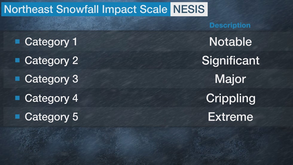
In 2004, Paul Kocin, a National Weather Service meteorologist, and Dr. Louis Uccellini, the director of the National Weather Service, developed the Northeast Snowfall Impact Scale (NESIS) scale to rank the impact of Northeast snowstorms based on snowfall amounts and the population affected.

In general, widespread heavy snowfall over highly populated areas like the Interstate 95 corridor from Boston to Washington, D.C. produces a high NESIS value. The storms are ranked Category 1 (notable) to Category 5 (extreme) based on the value.

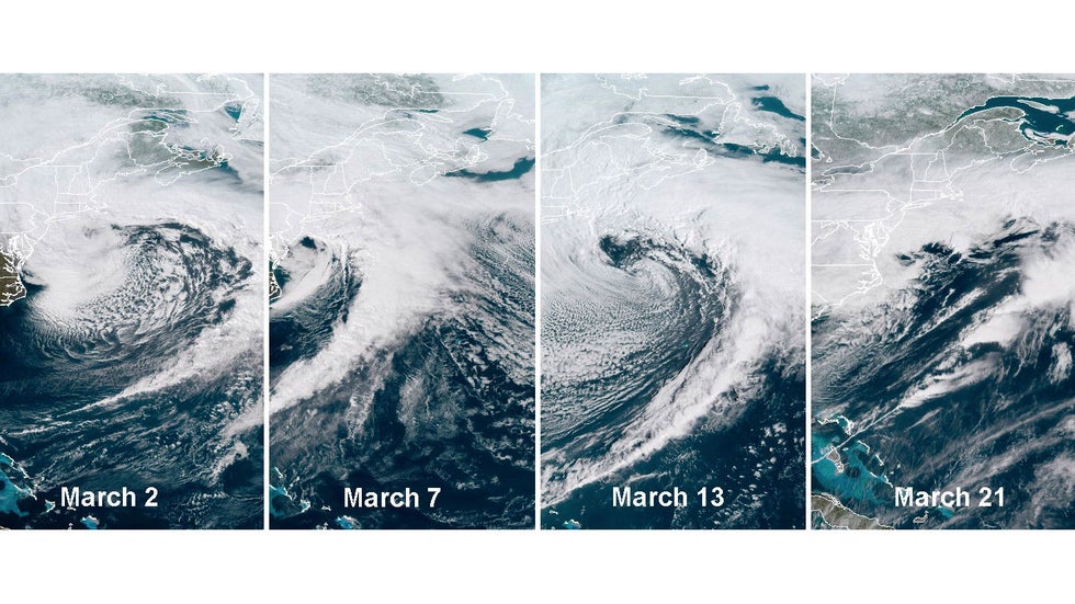
The last time a Northeast urban corridor winter storm ranked as at least a Category 1 on the NESIS was March 2018, when four Nor'easters pummelled the East Coast in three weeks. Those storms all ranked either Category 1 or 2.

Since then, there have been no high-impact snowstorms in the Northeast urban corridor in the last two snow seasons; that's unusual.

Until winter 2018-2019, there was at least one winter storm for 10 consecutive snow seasons with a NESIS rating of Category 1 or greater. Six of those 10 seasons had multiple storms with a Category 1 or higher rating.

But we have to go back farther in time to find the last time a high-impact snowstorm failed to appear in back-to-back winters. That last happened in the 1998-1999 and 1997-1998 snow seasons.

Satellite of the four nor'easters in March 2018.

Snow and ice have been impactful at times in the Northeast during the past two winters, but none of the events have been heavy or widespread enough to earn at least a Category 1 NESIS rating.

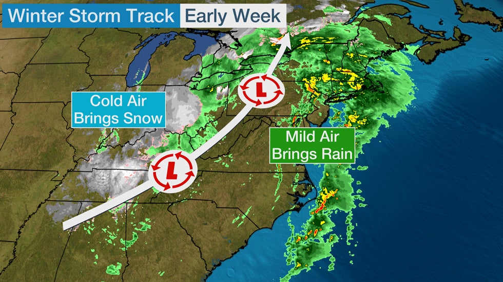
That's because the general track of significant winter storms has been northeastward across the central United States. This storm track draws milder air into the Northeast, resulting in more rain than snow.

We saw another example of an unfavorable storm track for snowfall in the urban corridor early this week.

Winter Storm Dane, as named by The Weather Channel, tracked up the spine of the Appalachians into the interior Northeast on Monday. That track drew mild air on southerly winds into the Northeast, resulting in widespread rain on the East Coast all the way into Maine. Snowfall was confined to the colder air on the storm's western flank, from the Appalachians to the eastern Great Lakes.

What Will Happen This Winter?

It's impossible to definitively say whether the Northeast urban corridor will see any high-impact snowstorms this winter.

That will depend on the track of storm systems in the coming months and how much cold air is readily available to produce snowfall. Those details happen on a timescale that can't be predicted far in advance.

One factor that could skew snowfall below average in the urban corridor this winter is the ongoing La Niña event in the equatorial Pacific Ocean.

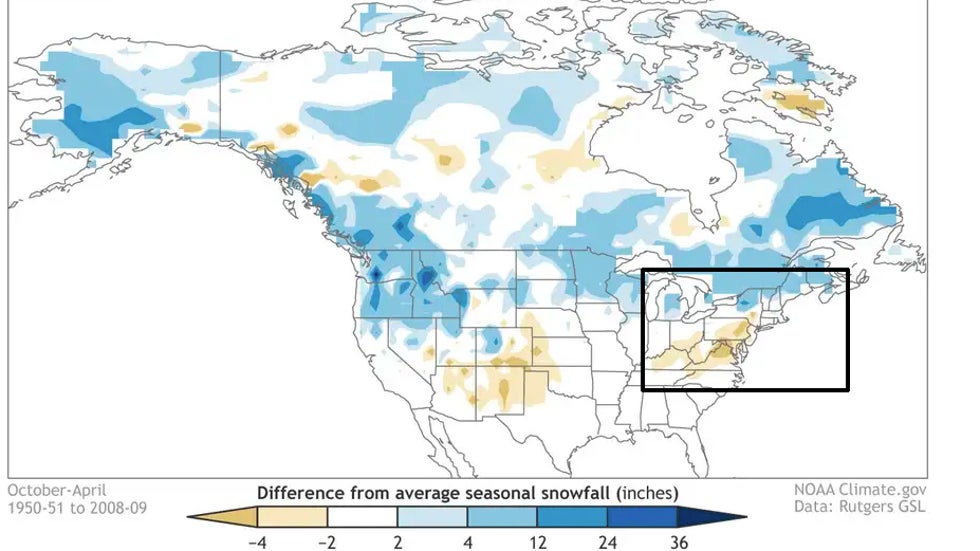
La Niña winters have historically produced below-average snowfall in a portion of the Northeast urban corridor, according to research by Dr. Stephen Baxter, a meteorologist with NOAA's Climate Prediction Center. This is shown using the brown (below-average snowfall) shadings over the region in the graphic below.

Snowfall departure from average for all La Niña winters (1950-2009), based on analysis at the Climate Prediction Center using Rutgers gridded snow data. Blue shading shows where snowfall is above average, and brown shows where snowfall is below average.

Stronger La Niña events like we could see this winter tend to be the least snowy in the Northeast urban corridor, according to the study. Conversely, snowfall is closer to average in weaker La Niña events.

It's also important to note that there could be other overriding factors in the atmosphere that might affect snowfall trends this winter.

Here's another article that goes further into detail about how La Niña and other atmospheric factors could affect Northeast snowfall this winter.

The Weather Company’s primary journalistic mission is to report on breaking weather news, the environment and the importance of science to our lives. This story does not necessarily represent the position of our parent company, IBM.

The Weather Company’s primary journalistic mission is to report on breaking weather news, the environment and the importance of science to our lives. This story does not necessarily represent the position of our parent company, IBM.

Frigid Temperatures, Coronavirus Pandemic Significantly Add to Homeless Shelters' Burdens

 Ron Brackett

Published: November 30, 2020


Homeless shelters often struggle to find beds for everyone who needs one in the best of times. Now, with temperatures falling and COVID-19 infections surging, this perennial problem could potentially be even deadlier this winter.

Many shelters have had to limit capacity as governments impose restrictions aimed at slowing the spread of the new coronavirus, yet homeless people are among those most at risk.

"The homeless check off most boxes in terms of being the most susceptible and most vulnerable to the COVID-19 pandemic, and most likely to spread and most likely to die from it," Neli Vazquez Rowland, founder of A Safe Haven Foundation in Chicago, told Kaiser Health News.

"The challenge is going to be extreme this winter," Michael Basford, director of Wisconsin's Department of Administration's Interagency Council on Homelessness, told Wisconsin Public Radio.

The problem also is widespread.

-In Janesville, Wisconsin, GIFTS Men’s Shelter may be able to use only 11 of its 42 beds under the Rock County Public Health Department’s COVID-19 recommendation that businesses and public places limit occupancy to 25% capacity, according to the Janesville Gazette.

(MORE: Winter Storm Bringing Snowfall From Great Lakes to Appalachians)

-In St. Joseph, Missouri, Community Action Partnership St. Joseph has shuffled around sleeping arrangements to increase capacity from 42 to 55 after COVID-19 regulations cut into its 72-bed capacity, the St. Joseph News-Press reported.

-The Onslow County homeless shelter in Jacksonville, North Carolina, had to be moved because the old facility didn't have room to allow for social distancing, WITN-TV reported. The new shelter is roomier, but it has already reached capacity. Emergency space may be available, but "our flex space can only be used when we’ve had the consensus of our health department director and our fire marshal," Onslow Community Outreach Chair Don Herring said. "That space is only used for emergencies that are designated by the city, county or the state."

-In Kent County, Delaware, the nonprofit Code Purple needs mattresses. Like many organizations that help the homeless, Code Purple is testing individuals for COVID-19. "If a client has symptoms, we have to toss the bed," Ennio Emmanuel, president of Code Purple, told Delaware State News.

-The Valley Youth House shelter for homeless children in Bethlehem, Pennsylvania, cut the number of kids it can house from 12 to eight to allow for social distancing. "We’ve had kids show up on our doorstep in the freezing cold in the middle of the night," Michele Albright, supportive housing program supervisor for the shelter, told the Morning Call. "Ours is the only place for them to go because we’re the only public shelter for children in this area."

-Last week, 26 clients of the Boise, Idaho, Rescue Mission were in quarantine either because of a positive COVID-19 test or they were awaiting a test result, BoiseDev reported.

(WATCH: Here's Where December Could Be the Snowiest Month of the Season)

-In Ohio, Akron's Peter Maurin Center usually has space for 50 individuals, but this year, because it can't provide proper social distance, it will not open. Dave Churbock, the center's director, told the Akron Beacon Journal it is trying to find another space to house an emergency shelter or it may donate its mats, pillows and blankets to another group that can offer overnight stays.

-In St. Louis, the nonprofit Winter Outreach used to shuttle homeless people to as many as a dozen shelters. This year it has three shelters available, the St. Louis Post-Dispatch reported. Also, fewer volunteers are stepping up to drive the vans, which carry fewer people on each trip because of the need to remain socially distanced.

"I’m anxious," said Teka Childress, Winter Outreach's founder. "I’m always afraid someone is going to die during the winter. And it’s the worst thing in the world when it happens. We want to do everything to prevent it. (But) adding to the concern about keeping people safe and alive and housed this winter is trying to protect the people with great hearts keeping them safe. It’s just a daunting challenge."

Doug Schenkelberg, executive director of the Chicago Coalition for the Homeless, said to Kaiser Health News, "What happens if we're in the midst of a pandemic and a polar vortex happens? We're trying to keep the contagion from spreading and keep people from dealing with hypothermia. Is there the infrastructure in place that can handle that type of dual crisis?"

Across the country, organizations are seeking alternatives to traditional shelters to keep people warm and safe.

As many coastal communities did this summer when hurricanes forced evacuations, officials are increasingly turning to hotel rooms as shelter space. The search for options doesn't stop there, however, as Kaiser Health News reported:

-In St. Paul, Minnesota, Ramsey County officials plan to lease an old hospital to shelter 100 homeless people.

-The New Life Center in Fargo, North Dakota, plans to use an insulated, heated warehouse as a shelter.

-The city of Chicago opened emergency shelters in two unused public school buildings.

The Salvation Army’s William Booth Center in Seattle, which has gone from 190 beds to 90, is allowing clients to alter their sleeping spaces.

"We’re allowing people to do what we call tenting, or putting sheets all around," shelter director Gina Sullivan told the Seattle Times. "That’s something in normal times we don’t allow because we do need to see if people are in their beds."
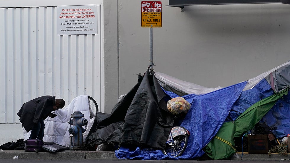
A man stands near tents set up on a sidewalk in San Francisco, Saturday, Nov. 21, 2020. Some counties in California are pushing ahead with plans to wind down a program that's housed homeless people in hotel rooms amid the pandemic, despite an emergency cash infusion from the state aimed at preventing those same residents from returning to the streets in cold, rainy weather as the virus surges.

Will Towne is the director of housing and operations at Spectrum Youth and Families Services, which provides shelters for young people ages 16 to 24 in Burlington, Vermont. He told Vermont Public Radio the organization is focused on incorporating concerns over the coronavirus into its normal operations.

"We always go into the winter with a certain level of concern. I mean, we talk about safety so much right now in terms of the COVID-19 pandemic, but a huge part of people's safety is having a roof over their head, as well," Towne said. "So we really need to focus on a way to balance those two ideas and integrate our approaches for COVID safety into being able to still provide our services to the youth that we serve."

Spectrum has worked to ensure there is enough space in its congregate living facility for clients to distance themselves physically. Masks are required and staffers wear personal protective equipment. The facility uses air filtration systems, UV-C light filtration systems and HEPA air filters, Towne said. Surfaces are wiped down three times a day and a janitorial service disinfects the facility daily.

The Greater Valley YMCA in Allentown, Pennsylvania, moved its homeless shelter from its basement to the larger gym space.

"We’re much better prepared for the beginning of this winter than we were at the end of last winter, when this thing came flying out of left field," CEO David Fagerstrom told the Morning Call.

The Code Purple agency in Dover, Delaware, is putting plexiglass dividers between beds.

The Briarcliff Ossining Ministerial Association in New York's Westchester County will turn 6-foot-long cafeteria tables on their sides between beds in its shelters, the Rockland/Westchester Journal News reported. The association will also use curches only in downtown Ossining that are within walking distance so that people won't have to crowd into vans. Instead of rotating among the churches weekly, each church will host a shelter for several weeks to cut down on how often each must carry out COVID-19 protocols.

(MORE: Mysterious Monolith in Utah Disappears)

At the Onslow County shelter in North Carolina, clients won't be turned away empty-handed if there is no room for them. The shelter will give out cold-weather kits that include blankets, hats, tents and hand-warmers.

"If they have to sleep outdoors, that will help them bear the cold," shelter director Cindy Williams said. "We do the best that we can to help them face the cold if they have to."

Farther north, where temperatures routinely drop below freezing, being outside is not an option.

"I just have a rather substantial concern that ... we're going to need to find ways to get people who are outside, inside over the winter," said Basford, of Wisconsin's homeless council. "But if we fail to have that happen, my biggest fear is that we're going to have people die outside in the cold ... that keeps me up at night."

The Weather Company’s primary journalistic mission is to report on breaking weather news, the environment and the importance of science to our lives. This story does not necessarily represent the position of our parent company, IBM.
The Weather Company’s primary journalistic mission is to report on breaking weather news, the environment and the importance of science to our lives. This story does not necessarily represent the position of our parent company, IBM.

As Meteorological Winter Begins, Here Are 5 Extreme Weather Patterns to Look For

 Chris Dolce

Published: November 30, 2020


The start of December marks the transition into meteorological winter, and that means parts of the United States could face crippling snowstorms, ice storms and severe cold blasts in the months ahead.

Forecasters look for certain large-scale weather patterns that can sometimes signal the arrival of extreme winter weather conditions to give time for people to prepare.

Here are a few of the weather patterns we watch.

1. East Coast Snowstorm Pattern

Meteorologists monitor an index called the North Atlantic Oscillation (NAO) when examining the potential for a blockbuster East Coast winter storm. The index has a positive and negative phase, and as its name implies, it oscillates between those phases to various degrees over periods of days or weeks.

The NAO is just one factor in the grand scheme of forecasting, but when it slips into a deeply negative state, East Coast snow-loving weather geeks begin to salivate. 

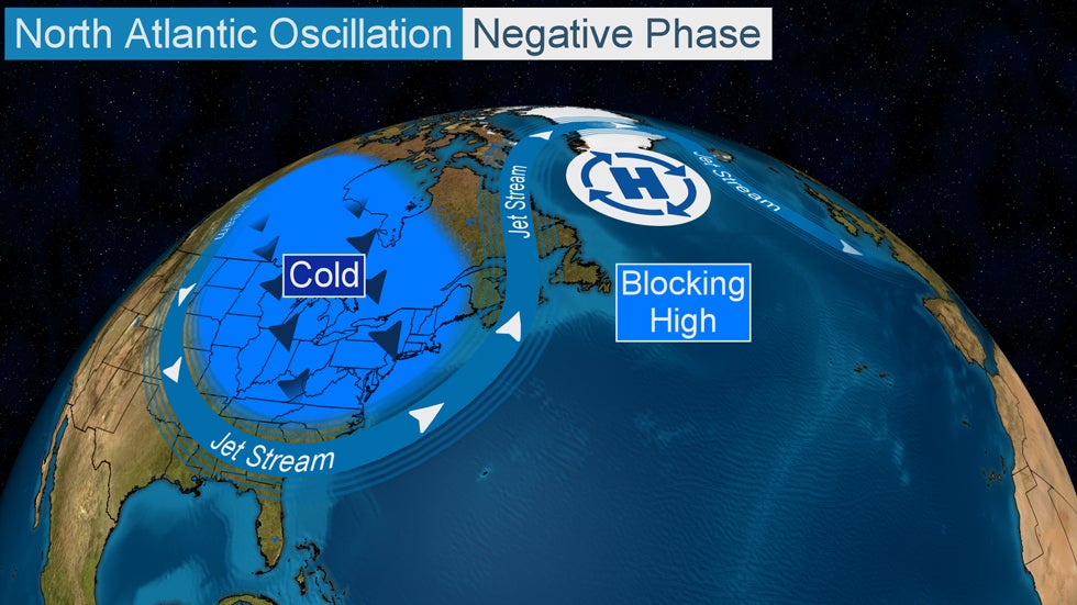
The area of blocking high pressure near Greenland locks in a southward dip in the jet stream across the eastern states when the NAO is in its negative phase. This leads to persistent cold temperatures and the potential for East Coast snowstorms.

The jet stream dips southward over the eastern United States during a negative phase of the NAO in the colder months of the year, where it may lock in for a long period of time. This is due to what meteorologists call atmospheric blocking. In the case of a negative NAO, the block often takes the form of a strong bubble of high pressure near Greenland. 

Depending on the orientation of the jet stream dip, and the potency and evolution of disturbances traversing it, one or more major snowstorms can spin up and impact some part of the East Coast or Atlantic Canada.

The blocking in the NAO negative phase allows intensifying low-pressure systems to crawl up near or just off the Eastern Seaboard rather than scooting harmlessly out to sea.

A recent example of this occurred in March 2018 when the NAO slipped into a negative phase for about three weeks. This period produced four nor'easters that brought heavy snow, blizzard conditions and coastal flooding to portions of the mid-Atlantic and Northeast. 

All of this said, the Northeast can still see significant snowstorms even without a negative NAO.

2. The Arctic Express

Forecasters look to Alaska, Canada's Arctic region and even Siberia for signs of bitterly cold air masses building during the heart of winter.

Highlighted by the ring and shaded pink and purple is an arctic air mass that descended southward into the U.S. from near the North Pole during February 2016.

Arctic air masses from those source regions don't always pour south of the Canadian border when they develop, but when they do, the continental U.S. usually experiences its most extreme cold outbreaks of the winter.

The frigid air from those regions is typically dislodged when the jet stream builds northward over western North America. As a result, a southward plunge of the jet stream sweeps across the central and eastern United States, ushering in the shivering, and in some cases, subzero temperatures.

3. Long-Lasting West Coast Atmospheric Rivers

One of the most extreme weather patterns for the West Coast during winter is an atmospheric river.

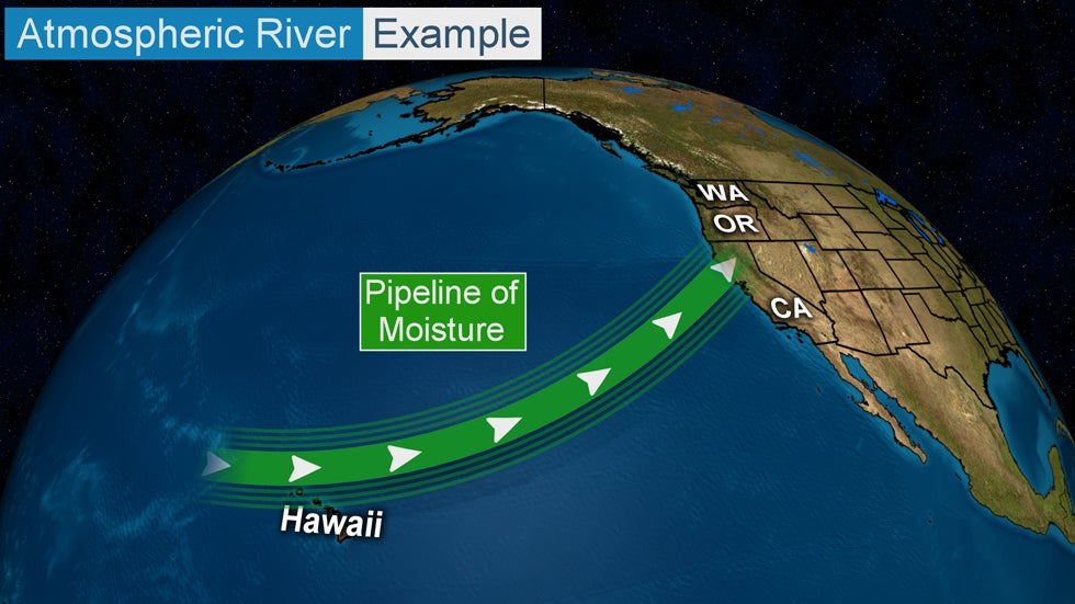
An atmospheric river is a narrow plume of moisture extending from the tropics or subtropics that Pacific storm systems can tap into as they plow inland.

A long plume of moisture in the atmosphere that stretches from the tropics (or subtropics) to the West Coast of the U.S.

The atmospheric river provides extra juice to storm systems taking aim at the coasts of Washington, Oregon and/or California. Sometimes the extra moisture can be overwhelming, with heavy rain causing flooding while feet of snow pile up in higher terrain.

Atmospheric rivers form many times from fall through early spring, but their potency can vary from weak to exceptionally strong.

A total of 40 atmospheric river events were documented last season in the six months from October 2019 through March 2020, from near San Diego to Washington's Olympic Peninsula, according to the Center for Western Weather and Water Extremes (CW3E). Seven of the 40 atmospheric rivers were classified as strong.

Atmospheric river events can bring hazardous conditions, but they are also beneficial since they help replenish the water supply in the West.

An example of a high-impact atmospheric river event happened in January 2017.

More than 10 feet of snow fell in the higher elevations of the Lake Tahoe region during a seven-day period. In the lower elevations, flooding rainfall affected parts of California and western Nevada. Some locations in California saw more than two feet of rain.

4. Expansive Ice Storms

Major ice storms are among the most high-impact winter weather events. They're destructive to trees and power lines and can bring travel to a standstill.

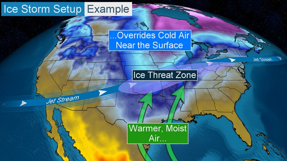
Example of a setup for a potential ice storm.

Some of the most expansive ice storms east of the Rockies develop in a weather pattern easily recognized by meteorologists.

Typically this setup features arctic air that is fed by a northerly wind near the earth's surface. This cold air source is then overrun by mild, moist air ushered in on southerly winds from the Gulf of Mexico.

The jet stream sends disturbances over the top of this battleground between cold and mild air, adding additional lift to the atmosphere. The result is a large swath of precipitation that can extend for hundreds of miles in a west-to-east fashion.

Depending on the intensity and longevity of the freezing rain that develops, impacts can range from nuisance to crippling in any given location.

An example of a rare, crippling ice storm happened in late October 2020 in parts of Oklahoma, southern Kansas and far northwest Texas. Ice accumulations a half-inch or more thick caused widespread tree damage and power outages in central and western Oklahoma, including in Oklahoma City.

More than 400,000 outages were reported at the height of the storm's impacts, according to OG&E, the region's primary utility provider. The company says that's the highest number of storm-related outages it's ever experienced.

The storm damaged or destroyed more than 1,300 power poles, 1,050 crossarms and 194 transformers, OG&E said.

5. Lake-Effect Snow Machine

Lake-effect snow downwind of the Great Lakes is a common occurrence from late fall through the heart of winter.

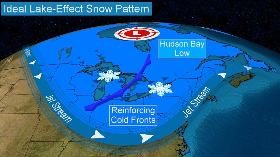
The ideal jet-stream pattern for generating heavy lake-effect snow.

Sometimes these events are short-lived, while others can pelt the same areas for days at a time.

Meteorologists take extra notice when a familiar setup for heavy lake-effect snow is projected by forecast-guidance tools. The pattern features a sharp, persistent southward plunge of the jet stream anchored over the eastern U.S. by a gyre of low pressure over or near Canada's Hudson Bay.

In this pattern, repeated rounds of cold air spill over the Great Lakes and manufacture bands of heavy lake-effect snow that can persist for several days in spots.

(MORE: What Is Lake-Effect Snow?)

Snowfall amounts measured in feet are typical during lake-effect snow events featuring this long-lived setup, particularly east of Lakes Erie and Ontario.

Left: A giant snow pile is left in the wake of the February 2007 lake-effect snowstorm. Right: Snowfall totals from the Feb. 3-12, 2007, lake-effect snowstorm in the Lake Ontario snowbelt.

One of the most extreme situations occurred over a 10-day period from Feb. 3-12, 2007, when an incredible 141 inches of snow was measured in Redfield, New York, about 50 miles northeast of Syracuse.

The Weather Company’s primary journalistic mission is to report on breaking weather news, the environment and the importance of science to our lives. This story does not necessarily represent the position of our parent company, IBM.

The Weather Company’s primary journalistic mission is to report on breaking weather news, the environment and the importance of science to our lives. This story does not necessarily represent the position of our parent company, IBM.


This Date in Weather History for December 1,2020

 Weather History

For Tuesday, December 1,2020


1831 - The coldest December of record in the northeastern U.S. commenced. Temperatures in New York City averaged 22 degrees, with just four days above freezing, and at Burlington VT the temperature never did get above freezing. The Erie Canal was closed the first day of December, and remained closed the entire month. (David Ludlum)
1896 - The temperature at Kipp, MT, rose 30 degrees in just seven minutes, and 80 degrees in a matter of a few hours. A thirty-inch snow cover was melted in half a day. (The Weather Channel)
1913 - A six day front range snowstorm began. It produced a record total of 46 inches at Denver CO. (David Ludlum)
1985 - A storm produced more than six inches of snow from the Northern and Central Plains to parts of Michigan, with 36.4 inches reported at Marquette MI. Many roads were blocked by snow. A family was stranded for 25 hours south of Colome SD. Drifts twelve feet high were reported in north central Nebraska. (The Weather Channel)
1987 - A powerful storm hit the northwestern U.S. Winds gusted to 80 mph at Cape Disappointment WA, and reached 94 mph at Cape Blanco OR. Thunderstorms in western Washington State produced wind gusts to 60 mph, and dime size hail at Hoquiam. Stevens Pass, in the Cascade Mountains of Washington, received seven inches of snow during the morning hours. (The National Weather Summary) (Storm Data)
1988 - Squalls in the Great Lakes Region produced up to a foot of snow in Ashtabula County OH, up to ten inches in Erie County PA, and up to a foot of snow in western New York State. (Storm Data) (The National Weather Summary)
1989 - Heavy snow blanketed the mountains of New Mexico, with 12 inches reported at the Angel Fire Ski Basin. Strong northerly winds ushering cold air into the north central U.S. gusted to 55 mph at Devils Lake ND. Low pressure over the Gulf of Alaska produced wind gusts to 69 mph at Kodiak Island. (Storm Data) (The National Weather Summary)
2002 - Heavy lake effect snow fell downwind of the U.S. Great Lakes. Buffalo, New York reported 16 inches of snow, with thundersnow reported late in the afternoon. While the eastern U.S. experienced much colder than normal temperatures on December 1, much of Alaska was basking in above average warmth. Many daily temperature records were set across this region through the beginning of the month.
2007 - During December 1-3, a powerful storm with hurricane force winds struck the Northwest U.S. The storm brought heavy rain and wind gusts over 100 mph, with the highest reading being 129 mph at Bay City, OR. The strong winds brought power lines down, and the heavy rain caused widespread flooding and triggered landslides (BBC News). According to reports, 8 fatalities were attributed to the storm and about 37,000 homes and businesses were left without power in Washington, Oregon, and northern California. President Bush declared a federal disaster in several counties in Washington and Oregon to provide recovery assistance (Associated Press).
2011 - Wind speeds as high as 102 MPH were measured in Centerville, Utah and surrounding cities. Damage was reported throughout Weber and Davis counties ranging from South Ogden down to Bountiful. More than 400 trees were down at the Davis Golf course alone due to the winds. Up to 54,000 residences were without power throughout the day and into the evening. Train service between Layton and Salt Lake City was suspended due to damaged train stations, debris on the train tracks, and power outages. Cleanup costs totaled $8 million in Centerville alone. No injuries were reported from the wind, but a number of injuries were reported from those helping with the cleanup effort.

Man missing at sea for nearly 2 weeks found alive in life raft off Washington coast

  One of two men missing at sea for nearly two weeks was found alive on Thursday by a Canadian fishing boat in a life raft in Canadian water...