Chris Dolce
The start of December marks the transition into meteorological winter, and that means parts of the United States could face crippling snowstorms, ice storms and severe cold blasts in the months ahead.
Forecasters look for certain large-scale weather patterns that can sometimes signal the arrival of extreme winter weather conditions to give time for people to prepare.
Here are a few of the weather patterns we watch.
1. East Coast Snowstorm Pattern
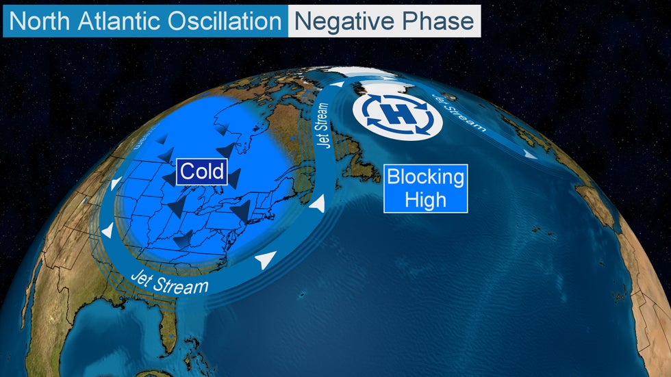
Meteorologists monitor an index called the North Atlantic Oscillation (NAO) when examining the potential for a blockbuster East Coast winter storm. The index has a positive and negative phase, and as its name implies, it oscillates between those phases to various degrees over periods of days or weeks.
The NAO is just one factor in the grand scheme of forecasting, but when it slips into a deeply negative state, East Coast snow-loving weather geeks begin to salivate.
 The area of blocking high pressure near Greenland locks in a southward dip in the jet stream across the eastern states when the NAO is in its negative phase. This leads to persistent cold temperatures and the potential for East Coast snowstorms.
The jet stream dips southward over the eastern United States during a negative phase of the NAO in the colder months of the year, where it may lock in for a long period of time. This is due to what meteorologists call atmospheric blocking. In the case of a negative NAO, the block often takes the form of a strong bubble of high pressure near Greenland.
Depending on the orientation of the jet stream dip, and the potency and evolution of disturbances traversing it, one or more major snowstorms can spin up and impact some part of the East Coast or Atlantic Canada.
The blocking in the NAO negative phase allows intensifying low-pressure systems to crawl up near or just off the Eastern Seaboard rather than scooting harmlessly out to sea.
A recent example of this occurred in March 2018 when the NAO slipped into a negative phase for about three weeks. This period produced four nor'easters that brought heavy snow, blizzard conditions and coastal flooding to portions of the mid-Atlantic and Northeast.
All of this said, the Northeast can still see significant snowstorms even without a negative NAO.
2. The Arctic Express
Forecasters look to Alaska, Canada's Arctic region and even Siberia for signs of bitterly cold air masses building during the heart of winter.
Arctic air masses from those source regions don't always pour south of the Canadian border when they develop, but when they do, the continental U.S. usually experiences its most extreme cold outbreaks of the winter.
The frigid air from those regions is typically dislodged when the jet stream builds northward over western North America. As a result, a southward plunge of the jet stream sweeps across the central and eastern United States, ushering in the shivering, and in some cases, subzero temperatures.
3. Long-Lasting West Coast Atmospheric Rivers
One of the most extreme weather patterns for the West Coast during winter is an atmospheric river.
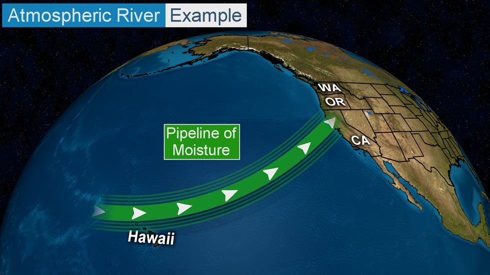
An atmospheric river is a narrow plume of moisture extending from the tropics or subtropics that Pacific storm systems can tap into as they plow inland.
 A long plume of moisture in the atmosphere that stretches from the tropics (or subtropics) to the West Coast of the U.S.
The atmospheric river provides extra juice to storm systems taking aim at the coasts of Washington, Oregon and/or California. Sometimes the extra moisture can be overwhelming, with heavy rain causing flooding while feet of snow pile up in higher terrain.
Atmospheric rivers form many times from fall through early spring, but their potency can vary from weak to exceptionally strong.
A total of 40 atmospheric river events were documented last season in the six months from October 2019 through March 2020, from near San Diego to Washington's Olympic Peninsula, according to the Center for Western Weather and Water Extremes (CW3E). Seven of the 40 atmospheric rivers were classified as strong.
Atmospheric river events can bring hazardous conditions, but they are also beneficial since they help replenish the water supply in the West.
An example of a high-impact atmospheric river event happened in January 2017.
More than 10 feet of snow fell in the higher elevations of the Lake Tahoe region during a seven-day period. In the lower elevations, flooding rainfall affected parts of California and western Nevada. Some locations in California saw more than two feet of rain.
4. Expansive Ice Storms
Major ice storms are among the most high-impact winter weather events. They're destructive to trees and power lines and can bring travel to a standstill.
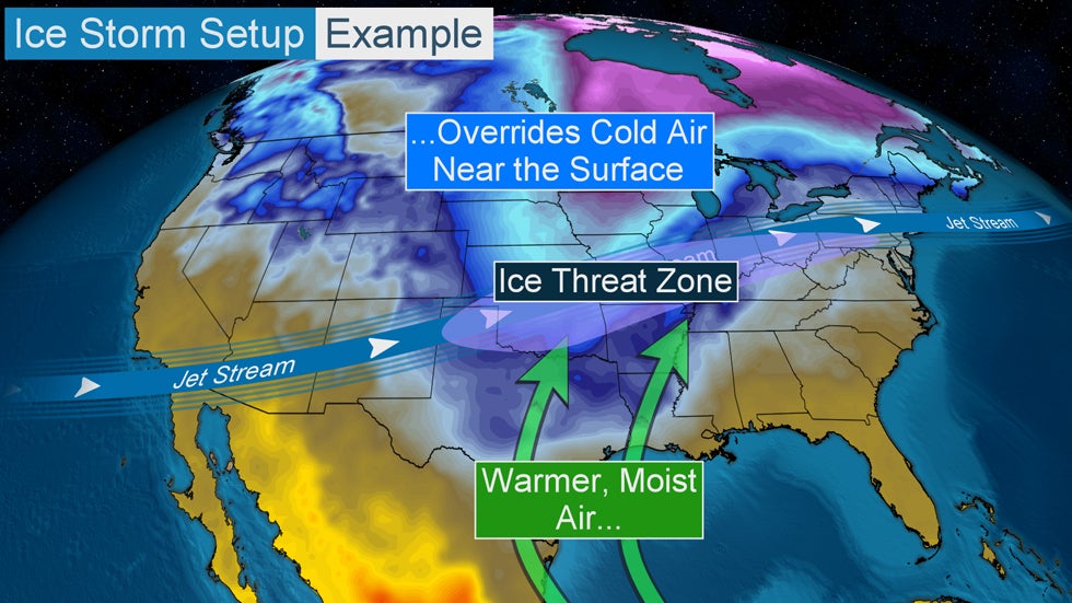
 Example of a setup for a potential ice storm.
Some of the most expansive ice storms east of the Rockies develop in a weather pattern easily recognized by meteorologists.
Typically this setup features arctic air that is fed by a northerly wind near the earth's surface. This cold air source is then overrun by mild, moist air ushered in on southerly winds from the Gulf of Mexico.
The jet stream sends disturbances over the top of this battleground between cold and mild air, adding additional lift to the atmosphere. The result is a large swath of precipitation that can extend for hundreds of miles in a west-to-east fashion.
Depending on the intensity and longevity of the freezing rain that develops, impacts can range from nuisance to crippling in any given location.
An example of a rare, crippling ice storm happened in late October 2020 in parts of Oklahoma, southern Kansas and far northwest Texas. Ice accumulations a half-inch or more thick caused widespread tree damage and power outages in central and western Oklahoma, including in Oklahoma City.
More than 400,000 outages were reported at the height of the storm's impacts, according to OG&E, the region's primary utility provider. The company says that's the highest number of storm-related outages it's ever experienced.
The storm damaged or destroyed more than 1,300 power poles, 1,050 crossarms and 194 transformers, OG&E said.
5. Lake-Effect Snow Machine
Lake-effect snow downwind of the Great Lakes is a common occurrence from late fall through the heart of winter.
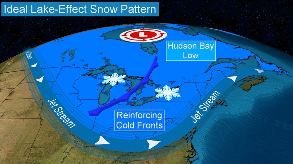
 The ideal jet-stream pattern for generating heavy lake-effect snow.
Sometimes these events are short-lived, while others can pelt the same areas for days at a time.
Meteorologists take extra notice when a familiar setup for heavy lake-effect snow is projected by forecast-guidance tools. The pattern features a sharp, persistent southward plunge of the jet stream anchored over the eastern U.S. by a gyre of low pressure over or near Canada's Hudson Bay.
In this pattern, repeated rounds of cold air spill over the Great Lakes and manufacture bands of heavy lake-effect snow that can persist for several days in spots.
(MORE: What Is Lake-Effect Snow?)
Snowfall amounts measured in feet are typical during lake-effect snow events featuring this long-lived setup, particularly east of Lakes Erie and Ontario.
 Left: A giant snow pile is left in the wake of the February 2007 lake-effect snowstorm. Right: Snowfall totals from the Feb. 3-12, 2007, lake-effect snowstorm in the Lake Ontario snowbelt.
One of the most extreme situations occurred over a 10-day period from Feb. 3-12, 2007, when an incredible 141 inches of snow was measured in Redfield, New York, about 50 miles northeast of Syracuse.
The Weather Company’s primary journalistic mission is to report on breaking weather news, the environment and the importance of science to our lives. This story does not necessarily represent the position of our parent company, IBM.
The Weather Company’s primary journalistic mission is to report on breaking weather news, the environment and the importance of science to our lives. This story does not necessarily represent the position of our parent company, IBM.

No comments:
Post a Comment