Jonathan Erdman
Another East Coast storm may develop this weekend, potentially bringing more snow to parts of the Northeast, Ohio Valley and Appalachians just hit by a snowstorm early this week.
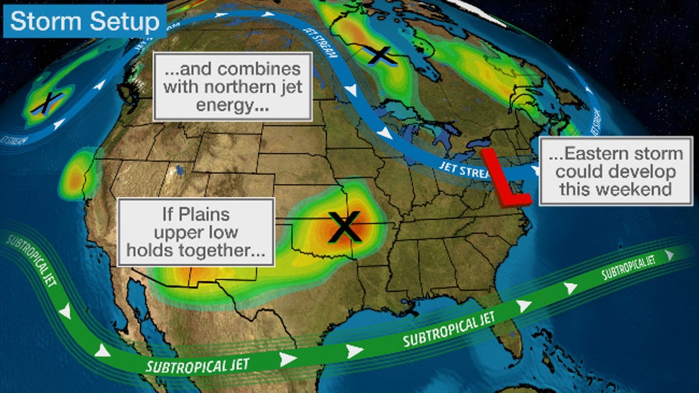
Similar to the storm affecting the East this week, named Winter Storm Dane by The Weather Channel, this potential weekend Eastern storm depends on whether energy from two jet streams can team up.
Namely, a large area of low pressure aloft spinning over the central Plains is expected to eventually be pulled eastward.
If that Plains upper low can remain fairly intact as it tracks east and can team up with disturbances in the northern branch of the jet stream, a strong area of low pressure could again form in the East this weekend.
For now, that's the scenario the majority of computer forecast models are suggesting.
But that's not guaranteed to happen. There are also the typical uncertainties with timing, the track of the Eastern low-pressure system and how much cold air will be available.
For now, we'll lay out our best outlook, but check back frequently for updates over the next few days as the forecast becomes clearer.
First, Plains Snow
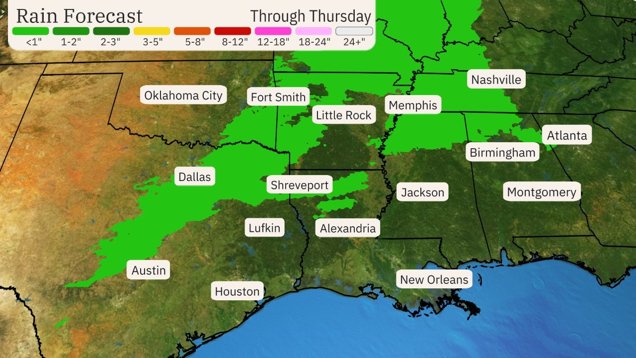
That Plains upper low will first generate a blanket of wet snow over parts of the Plains Wednesday and Wednesday night.
The biggest snow totals – over 6 inches in spots – are expected in parts of northwestern Oklahoma and southern Kansas.
Some lighter accumulations are possible in both the Wichita, Kansas, and Oklahoma City metro areas. This may lead to slick roads – especially bridges and overpasses – Wednesday night and early Thursday.
Friday's Outlook
Rain and a few thunderstorms are possible in the Southeast Friday.
Some precipitation should also spread into parts of the Northeast and Ohio Valley. Where some cold enough air is in place along the northern fringe, that precipitation may fall as snow, as shown in the forecast map below.
 Friday's Outlook
Saturday's Outlook
By Saturday, the majority of computer models suggest low pressure will have developed somewhere along the East Coast.
As mentioned earlier, the exact track of the low will be crucial for determining where the rain-snow line will set up.
For now, the best chance of snow Saturday stretches from parts of the Ohio Valley and eastern Great Lakes to the Appalachians and interior Northeast.
Closer to the Interstate 95 Northeast urban corridor, precipitation may fall mostly as rain Saturday and Saturday night.
(MORE: Northeast Urban Corridor 'High-Impact Snowstorm' Drought Enters Third Winter)
 Saturday's Outlook
Sunday's Outlook
By Sunday, most computer models suggest low pressure will be spinning somewhere near or over New England.
Assuming that happens, the best chance of accumulating snow Sunday and Sunday night is over the interior Northeast, mainly north and west of Interstate 95.
 Sunday's Outlook
Again, it's too soon to hone in on precise snow – and rain – total forecasts in the Northeast. Check back for updates in the coming days.
The Weather Company’s primary journalistic mission is to report on breaking weather news, the environment and the importance of science to our lives. This story does not necessarily represent the position of our parent company, IBM.
The Weather Company’s primary journalistic mission is to report on breaking weather news, the environment and the importance of science to our lives. This story does not necessarily represent the position of our parent company, IBM.


No comments:
Post a Comment