Chris Dolce
The Northeast urban corridor is entering its third winter without a "high-impact snowstorm" and expected climatological conditions this winter might keep this snowfall drought going strong.
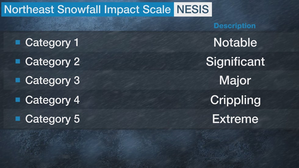
In 2004, Paul Kocin, a National Weather Service meteorologist, and Dr. Louis Uccellini, the director of the National Weather Service, developed the Northeast Snowfall Impact Scale (NESIS) scale to rank the impact of Northeast snowstorms based on snowfall amounts and the population affected.
In general, widespread heavy snowfall over highly populated areas like the Interstate 95 corridor from Boston to Washington, D.C. produces a high NESIS value. The storms are ranked Category 1 (notable) to Category 5 (extreme) based on the value.

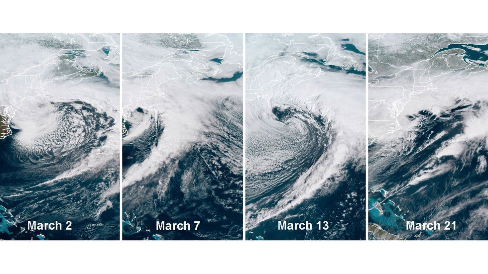
The last time a Northeast urban corridor winter storm ranked as at least a Category 1 on the NESIS was March 2018, when four Nor'easters pummelled the East Coast in three weeks. Those storms all ranked either Category 1 or 2.
Since then, there have been no high-impact snowstorms in the Northeast urban corridor in the last two snow seasons; that's unusual.
Until winter 2018-2019, there was at least one winter storm for 10 consecutive snow seasons with a NESIS rating of Category 1 or greater. Six of those 10 seasons had multiple storms with a Category 1 or higher rating.
But we have to go back farther in time to find the last time a high-impact snowstorm failed to appear in back-to-back winters. That last happened in the 1998-1999 and 1997-1998 snow seasons.
 Satellite of the four nor'easters in March 2018.
Snow and ice have been impactful at times in the Northeast during the past two winters, but none of the events have been heavy or widespread enough to earn at least a Category 1 NESIS rating.
That's because the general track of significant winter storms has been northeastward across the central United States. This storm track draws milder air into the Northeast, resulting in more rain than snow.
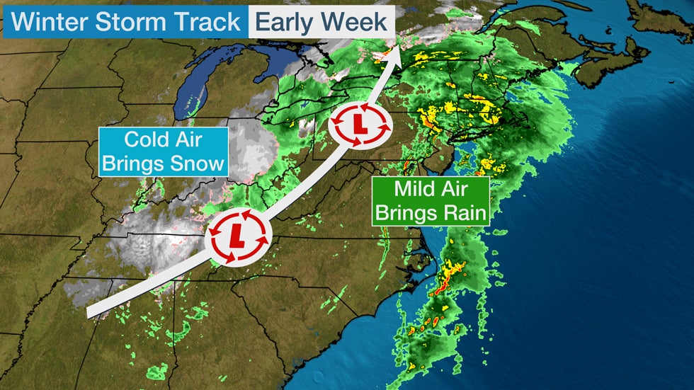
We saw another example of an unfavorable storm track for snowfall in the urban corridor early this week.
Winter Storm Dane, as named by The Weather Channel, tracked up the spine of the Appalachians into the interior Northeast on Monday. That track drew mild air on southerly winds into the Northeast, resulting in widespread rain on the East Coast all the way into Maine. Snowfall was confined to the colder air on the storm's western flank, from the Appalachians to the eastern Great Lakes.

What Will Happen This Winter?
It's impossible to definitively say whether the Northeast urban corridor will see any high-impact snowstorms this winter.
That will depend on the track of storm systems in the coming months and how much cold air is readily available to produce snowfall. Those details happen on a timescale that can't be predicted far in advance.
One factor that could skew snowfall below average in the urban corridor this winter is the ongoing La Niña event in the equatorial Pacific Ocean.
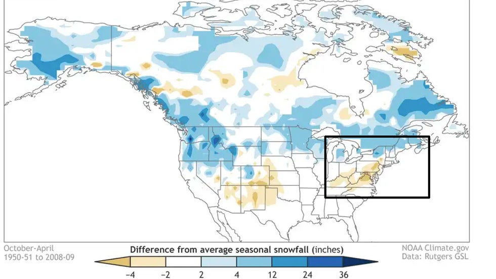
La Niña winters have historically produced below-average snowfall in a portion of the Northeast urban corridor, according to research by Dr. Stephen Baxter, a meteorologist with NOAA's Climate Prediction Center. This is shown using the brown (below-average snowfall) shadings over the region in the graphic below.
 Snowfall departure from average for all La Niña winters (1950-2009), based on analysis at the Climate Prediction Center using Rutgers gridded snow data. Blue shading shows where snowfall is above average, and brown shows where snowfall is below average.
Stronger La Niña events like we could see this winter tend to be the least snowy in the Northeast urban corridor, according to the study. Conversely, snowfall is closer to average in weaker La Niña events.
It's also important to note that there could be other overriding factors in the atmosphere that might affect snowfall trends this winter.
Here's another article that goes further into detail about how La Niña and other atmospheric factors could affect Northeast snowfall this winter.
The Weather Company’s primary journalistic mission is to report on breaking weather news, the environment and the importance of science to our lives. This story does not necessarily represent the position of our parent company, IBM.
The Weather Company’s primary journalistic mission is to report on breaking weather news, the environment and the importance of science to our lives. This story does not necessarily represent the position of our parent company, IBM.

No comments:
Post a Comment