2022's weather will be remembered largely for a pair of destructive strikes in Florida during an otherwise off-kilter hurricane season, areas repeatedly hit by tornadoes, and some bizarre record heat and drought.
But those were just a few of the weather oddities.
With that in mind, we ranked the 22 most bizarre things we saw in the year's weather, mainly in the United States. We also have a sizable list of honorable mentions below our top 22 list, simply because we love weird weather.
(PREVIOUS YEARS: 2021 | 2020 | 2019 | 2018)
22. Giant Snow Drifts Of South Dakota
Blizzards are a fact of life in the Plains. But in mid-December, Winter Storm Diaz produced blizzard conditions over parts of the Dakotas, eastern Montana, western Nebraska, eastern Wyoming and eastern Colorado for five straight days.
Combined with high winds, the snow was whipped into massive drifts over 10 feet high, reaching the roofs of some homes near Rapid City, South Dakota.
And if that wasn't enough, another blizzard – Winter Storm Elliott – struck some of the same areas in the days leading up to Christmas, producing whiteout conditions that stranded motorists on Interstate 90 in South Dakota.
21. Frozen Sand Sculptures
On a lighter note, we saw some amazing examples of nature's handiwork shortly after the new year rang in.
At a location better known for the spectacular frozen lighthouse, we instead noticed this photo of frozen sand sculptures after a January cold front blasted through.
It's not an exhibit at an art museum, but these bizarre formations resembled a miniature version of hoodoos in Utah or perhaps your child's clay sculpture made in art class.
20. Gustnado On The Ohio River
Waterspouts are common in summer along the Southeast coast, including Florida.
But in May, a boater on the Ohio River near Cincinnati was surprised by what appeared to be a waterspout crossing the river behind him.
It turned out this was instead a gustnado – a quick spinup along a thunderstorm's leading edge of outflow winds – rather than a full-fledged tornado.
According to the National Weather Service, this gustnado eventually produced significant tree damage in Sayler Park, Ohio, with some trees uprooted and "thrown onto homes and power lines."
19. Floodwaters Pour Into Las Vegas Casinos
In the Desert Southwest's summer monsoon, it's not unusual to see day after day of thunderstorms flare up each afternoon and evening.
This past summer, flooding rain swamped the Las Vegas Strip to the extent that it poured into some casinos twice in a span of two weeks – first on the night of July 28, then again two weeks later on Aug. 11.
We should have bet the over on Vegas rain in July and August.
18. The Greenest Sky We've Seen
If a derecho roaring through the Northern Plains and upper Midwest with winds over 90 mph wasn't attention-grabbing enough, a bizarre, green sky was seen over Sioux Falls, South Dakota, as the squall line moved through on July 5.
This eerie, green hue was caused by a large amount of hail and water in the line of thunderstorms coupled with the late afternoon sky, as explained by NWS meteorologist Cory Martin.
Winds of at least 58 mph blasted Sioux Falls for 45 minutes, according to the NWS.
17. Giant Washout In North Dakota Field
You may have seen a section of road or a bridge wash out in torrential rain, but the size of this washout in eastern North Dakota was on another level.
After a mid-April blizzard dumped up to 30 inches of snow in parts of North Dakota, a spring rainstorm nine days later dumped over 3 inches of rain. That rain on top of the wet, heavy snowpack was simply too much water to handle.
Near the town of Hatton, the resulting floods carved a 30-foot-deep chasm that was about the length of a football field.
North Dakota's storm fatigue continued into fall and early winter. Through late December, it was Bismarck's snowiest start to any snow season on record.
16. Lightning 1, Toilet 0
We've written about the damage potential of lightning, but it's always jarring to see a new example of its power.
On May 4, lightning struck an apartment complex in Okmulgee, Oklahoma. It went straight through the ceiling into an exhaust fan, and then obliterated a toilet in one apartment unit.
The strike triggered a brief attic fire that was quickly put out by firefighters.
It reminded us of another instance in August 2019 when a Florida lightning strike ignited methane gas that formed in a home's septic tank, shattering the toilet.
15. August, November Switch Places In Hurricane Season
By some measures, the 2022 Atlantic hurricane season was average. But that masked a lot of oddities during the season.
First and foremost, the season seemed to have calendar confusion.
August, typically one of the most active months, had zero storms form during the month for the first time in 25 years and only the third time since 1950.
Instead, November's activity wrapping up hurricane season more closely resembled a typical August. Hurricane Nicole was the latest-in-season hurricane to strike Florida's Atlantic coast on record, and a damaging one at that.
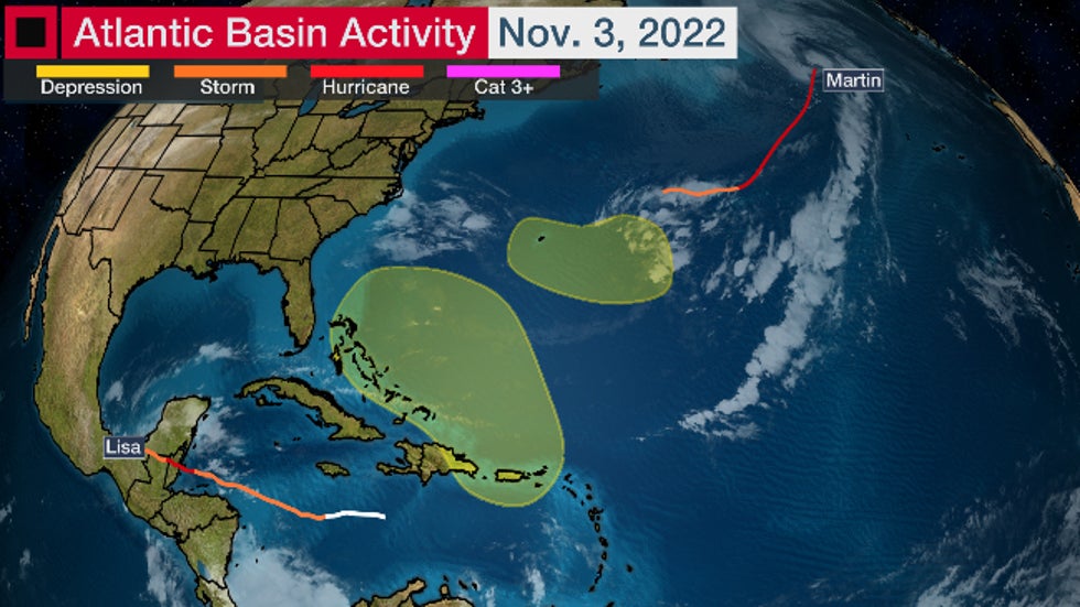 This map showed the two areas the NHC was monitoring for possible development (in yellow), and the tracks histories of both Lisa and Martin as of Nov. 3, 2022. Nicole eventually formed within the yellow area in the Bermuda Triangle on Nov. 7.
14. Church Laid On Its Side In EF3 Tornado
Usually, tornado damage we see is sobering. People's lives are upended, their belongings scattered to the wind.
In what was the nation's fourth tornado outbreak in four weeks, one thing in the wreckage of the April 12 Salado, Texas, EF3 tornado particularly caught our eye.
While some homes were destroyed or damaged, one church was pushed off its foundation and tipped at roughly a 45-degree angle. You can see that 15 seconds into the video below.
The tornado damaged 61 homes and injured 23 along its 13-mile path in Bell County. It also produced a 5.5-inch diameter hailstone, larger than a grapefruit.
13. Grapefruit-Size Hail Smashes National Record
Canada might not come to mind first when you think of giant hail, but August kicked off with a damaging hailstorm in Alberta that was later found to be a record-breaker.
A supercell thunderstorm between Edmonton and Calgary pelted the ground with hailstones up to grapefruit size on Aug. 1. Dozens of vehicles were damaged and some motorists were forced to crouch down as the massive hailstones smashed their car windows.
Scientists with the Northern Hail Project captured several bags full of giant hailstones and later found one hailstone set a new national record for both weight (about 0.65 pounds) and diameter (4.84 inches).
“It wasn’t until I returned and started sifting through the bags that I found the record-breaking stone,” said Francis Lavigne-Theriault, NHP field team leader, in the final report. “It was bagged with other stones without realizing what we had in our possession!”
12. Ski Or Sand Slopes?
In mid-March, skiers and snowboarders in the Pyrenees of southern France were treated to a surreal experience. It wasn't deep, fresh powder, but rather a coating of dust from the Sahara Desert lofted by winds into western Europe.
With the dust coating many of the slopes, it looked like snowboarding down sand dunes instead of mountains.
11. Plane's Nose Gone After Flying Through Thunderstorms
You might have flown through turbulence or around thunderstorms, but that likely didn't come close to the nightmare passengers on a flight over Paraguay experienced in October.
The Airbus 320 flew through a line of thunderstorms, subjecting passengers to violent drops in altitude, which required an emergency landing in Asunción, Paraguay, on Oct. 27.
Once it landed, photos showed the plane was missing its nose, and its windshield was peppered with pockmarks from large hail.
As of mid-November, the investigation was still ongoing.
10. EF4 Tornado In Iowa, In Early March
Tornadoes usually aren't top of mind in the upper Midwest in early March.
On March 5, the combination of unusually warm, humid air and a strong jet stream ignited severe thunderstorms which produced 13 tornadoes in Iowa alone.
One supercell spawned an EF4 tornado that was on the ground for 70 miles across central Iowa, killing six.
It was Iowa's first EF4 tornado since Oct. 4, 2013, and the state's longest tornado track since 1984, according to the NWS. Only twice before – in 1979 and 1990 – had such an intense tornado struck the Hawkeye State in March.
It could have been even worse if its track was about 5 to 10 miles farther north, which would have taken it into the heart of Des Moines.
Because it was early March, several inches of snow covered many of the tornado-damaged areas the following evening. And since a cold snap followed the tornadoes, there was even a sighting of hail still on the ground nine days after the severe weather outbreak.
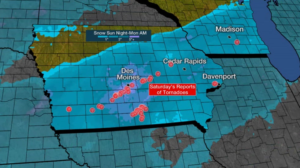 Red dots were initial reports of tornadoes on March 5, 2022. The contours denote estimated snowfall from the night of March 6-7, 2022.
9. Yellowstone National Park's Massive Flood
Among the destructive flash floods we witnessed in the U.S. in 2022, including the St. Louis, Kentucky, and Dallas-Fort Worth disasters, perhaps none was quite as shocking as what happened in the northern Rockies.
In the second week of June, heavy rain from an atmospheric river soaked the northern Rockies just as warmer weather was melting the area's heavy snowpack from winter, triggering "flooding rarely or never seen before across many area rivers and streams," according to the NWS in Billings, Montana.
Flooding, washed-out roads, rockslides and mudslides forced the closure of Yellowstone National Park on June 13; Over 10,000 visitors were evacuated from the park.
Nine days later, the park's west, south and east entrances reopened. However, the northern entrance would remain closed until repair work was completed on Oct. 30.
Cooke City and Gardiner, Montana, were heavily impacted, with homes, roads and bridges either flooded or washed away. Historic flooding swept through Red Lodge, Montana, where homes were either flooded or collapsed into the swollen Rock Creek.
Flood crest records were obliterated along stretches of the Clark's Fork of the Yellowstone, Stillwater and Yellowstone rivers. A record crest of the Yellowstone River forced the water treatment plant in Billings, Montana, to shut down for a day.
Strangely, much of this area was in drought just days before the heavy rain arrived, according to the U.S. Drought Monitor.
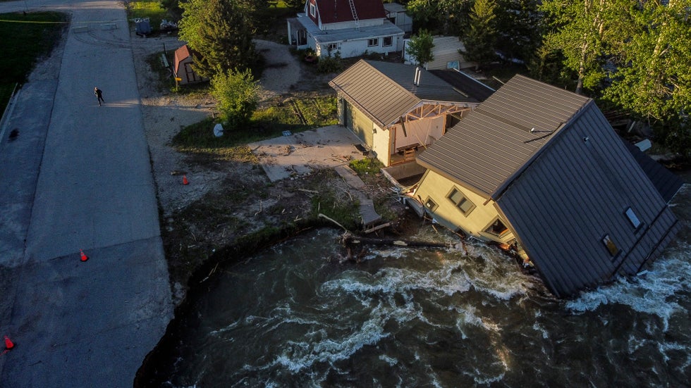 A house sits in Rock Creek after floodwaters washed away a road and a bridge in Red Lodge, Montana, Wednesday, June 15, 2022. The same flood forced the closure of nearby Yellowstone National Park.
8. Fiona, The Record-Smasher
The first impactful hurricane of the 2022 Atlantic hurricane season appeared to have set records in two vastly different places.
Fiona first soaked the northern Leeward Islands, then Puerto Rico in mid-September. Fiona knocked out power to all of Puerto Rico, and up to 32 inches of rain triggered destructive flooding on the island. Fiona may have topped Puerto Rico's all-time 24-hour rainfall record of 23.75 inches set in Oct. 1985.
While it became a post-tropical cyclone before landfall, Fiona was Canada's record-strongest storm by central pressure when it pushed into Nova Scotia on Sept. 24 with destructive storm surge and winds.
Fiona was the costliest weather event on record in Atlantic Canada and is expected to be at least a billion-dollar disaster in Puerto Rico, according to NOAA.
(MORE: Full Fiona Recap)
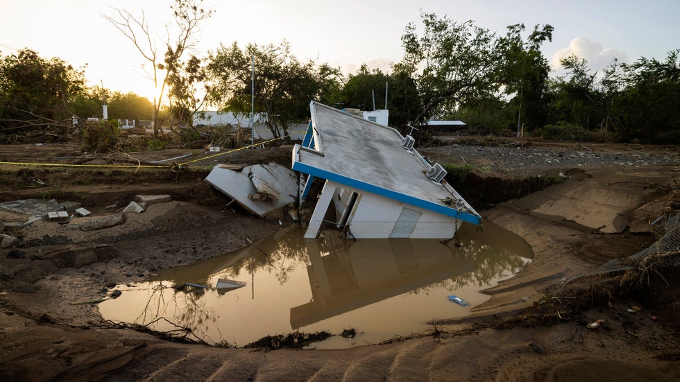 A badly damaged home is seen after it was washed away by Hurricane Fiona at Villa Esperanza in Salinas, Puerto Rico, Wednesday, Sept. 21, 2022. The storm knocked out power to the entire island.
7. Ian Matched Charley's Landfall Location
Category 4 Hurricane Ian slammed into Southwest Florida on Sept. 28 as one of the strongest hurricanes by wind speed to landfall in the state with devastating storm surge flooding, high winds and rainfall flooding. It is likely to be among the deadliest and costliest hurricanes in U.S. history.
(FULL RECAP: Hurricane Ian)
Among the most bizarre things we saw in Ian: its initial landfall location near Cayo Costa, Florida, was exactly the same landfall location as Hurricane Charley 18 years ago, with the exact same maximum winds and nearly identical central pressure. That said, Ian and Charley were much different, as a piece we wrote broke down in detail.
Other oddities with Ian included Orlando's 24-hour rainfall record (12.49 inches), shocking inland flooding along the St. Johns River that in one location lasted until after Christmas due also to rain from Hurricane Nicole. Instead of a life-threatening storm surge, Tampa Bay witnessed a blowout tide as Ian's center curled well south.
6. Two Different Parts Of New Orleans Metro Hit Twice In 2022
In the March 22 severe weather outbreak over the Deep South, an EF3 tornado tore through the eastern New Orleans metro, including Terrytown and Arabi, tossing a home while a family was inside.
Less than nine months later, another tornado, rated EF2, also tore through parts of Terrytown and Arabi. As the tweet from the NWS below showed, the March and December tornado tracks crossed in Arabi.
WDSU-TV reported a brewery that was destroyed by the March tornado had just replaced its roof weeks before the December tornado destroyed it again.
That wasn't the only double tornado occurrence in Southeast Louisiana in 2022.
A pair of weak tornadoes, rated EF1 and EF0, struck nearly the same location near Lacombe, Louisiana, within a week's time in late March. An NWS damage survey found different tree damage in the same yard from each tornado.
5. When 40 Degrees Pummeled A Record
Forty degrees may not sound warm to most of you, even in winter.
But in early December, it happened north of the Arctic Circle, and that was one of the most bizarre records we saw in 2022.
America's northernmost town, Utqiagvik (formerly known as Barrow), Alaska, soared to 40 degrees on the morning of Dec. 5.
That not only smashed the town's December record, but it was their warmest day anytime from Oct. 20 to April 22, according to the NWS. And it happened during a time of year with no sunshine above the horizon to provide warmth.
Alaska climate specialist Rick Thoman explained this was due to strong southerly winds breaking up the normal winter temperature inversion, bringing warmer air to the ground. Thoman also suggested ice-free water southwest of Utqiagvik may have kept the air warmer than usual that morning.
The average high in Utqiagvik on Dec. 5 is only 3 degrees.
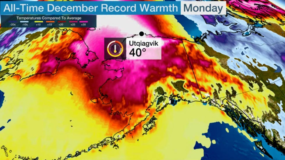 The all-time December record set in Utqiagvik, Alaska, on Dec. 5, 2022.
4. Three Years Of Rain In Eight Hours
While those in America were celebrating Thanksgiving, a city in the Middle East was hit by a historic rainfall event.
On Nov. 24, about 7 inches of rain fell in just eight hours in Jeddah, Saudi Arabia, their heaviest rainfall on record, according to Saudi Arabia's National Center For Meteorology.
As you might imagine, when a desert city picks up almost three times its yearly average rain in just a few hours, the flooding was severe and deadly. At least two were killed and water rescues were needed as city streets were inundated.
Jeddah averages only 13 days with rain each year. Nov. 24, 2022, was one day few will ever forget.
3. Planet's Most Anomalous Temperature On Record
Temperatures 20 or 30 degrees from average happen often in both heat waves and cold outbreaks.
But the warm temperature anomalies we witnessed in March 2022 over Antarctica were of a magnitude not previously seen by meteorologists nor climate scientists anywhere on Earth.
A multi-day heat wave spanned over half the continent in mid-March, pushing temperatures up to 70 degrees warmer than usual for that time of year.
Since it happened in Antarctica, that meant temperatures were near 14 degrees instead of mid-March averages around minus 58.
In a Twitter thread following the event, Berkeley Earth lead scientist Robert Rohde explained an atmospheric river of moist air intruding from the Southern Ocean, then a stalled pattern to trap the warm air, were responsible for this exceptional warmth.
Rohde also said it was unclear at the time how much of a role climate change played in this exceptional heat wave.
2. Shockingly Low Mississippi River
We've covered many Mississippi River floods over the years, including the Great Flood of 1993.
In 2022, it was record low levels along stretches of the river that offered some of the most surreal sights we saw during the year.
Following a generally dry summer in the Plains, then one of the driest Septembers on record from Louisiana to Missouri, Mississippi River levels plummeted to record lows in October from southeast Missouri to Mississippi.
Among the locations that set record low river levels were Caruthersville, Missouri; Osceola, Arkansas; Memphis, Tennessee; and Greenville, Mississippi. All four of these river gauges dipped below previous records that stood from the early 20th century.
In addition to impacts on barge traffic and saltwater intrusion from the Gulf of Mexico, the low water levels left behind some incredible scenes. Among those included a massive sand dune in the middle of the river (shown below) and an island rock that could be reached by foot.
Also revealed by these low water levels were a late-1800s shipwreck and other Civil War-era relics.
1. Wildfire Outbreak Largest Since World War II On U.K.'s Record Hot Day
As it was happening, it was fairly obvious what 2022's strangest weather event would be, even though it was occurring just seven months into the year.
The magnitude of the European heat wave in mid-July was staggering enough. Parts of France set their all-time heat records for a week straight beginning on July 11. On July 18, more than 100 locations in France set a new all-time record high, according to world weather records expert Maximiliano Herrera.
July was Spain's warmest month on record since at least 1961. At least one Spanish city set its all-time record high each day from July 12 to 17, including Madrid and Pamplona. Portugal also set a national heat record when Pinhão soared to 116.6 degrees on July 14.
But it was what happened in the United Kingdom that pushed this staggering event to the top of our 2022 list.
On July 18, high temperatures in the U.K. topped 100.4 degrees for only the third time in records dating to the mid-19th century.
The following day blew that threshold out of the water.
For the first time on record, a 104-degree temperature was recorded in the U.K. at Coningsby on July 19. Not only was the all-time U.K. heat record blown away (previously 101.7 degrees in Cambridge in July 2019), but all-time records in both Scotland (95.2 degrees) and Wales (98.8 degrees) were also topped in this heat wave.
In all, 46 reporting stations set new all-time heat records in the U.K., according to the U.K. Met Office.
This extraordinary heat led to a surge of fires across London and England. July 19 was the busiest day for the London Fire Brigade since World War II.
Flights were suspended at Luton Airport and Brize Norton air base after heat affected the runways. According to a U.K. Met Office report, sand was spread on some roads where melting had occurred in the heat.
Engineers resorted to wrapping a west London bridge in silver foil to supplement its cooling system and reflect the intense heat.
It was no surprise that Europe had its hottest summer on record and the U.K. had its record hottest year in 2022.
And all that hot, dry weather led to one of the worst droughts in decades in parts of western and southern Europe, leaving riverbeds dry and reservoirs resembling those in California's multi-year drought.
Honorable Mentions
There were a number of other oddities in 2022's weather that, while not making the top 22 list, we thought deserved at least a mention. They are listed in roughly chronological order.
-It was 99 degrees on New Year's Day at Falcon Lake, Texas, a national January heat record.
-A snowy tarmac kept President Joe Biden stuck on Air Force One.
-Fiji smashed its all-time 24-hour rainfall record.
-A plane skidded off a runway and damaged an airport's wind instrument.
-An Australian shopping center's roof collapsed due to heavy rain.
-The strongest Arctic storm on record led to its largest known ice loss.
-India medics waded through chest-deep snow to vaccinate residents.
-It was so cold they froze their pants off. (Don't worry, it's safe to watch.)
-A Florida couple accidentally drove into a tornado.
-Boston tied its single-day snowfall record.
-A Canadian man trekked through a blizzard for a meal but ended up with nothing.
-This tiny snowband almost set a state snowfall record.
-A blizzard blew snow inside this garage.
-Spectacular ice balls showed up in this Chinese lake.
-Watch this Icelandic "volcano-spout."
-Australia flooding trapped vehicles and horses on a bridge.
-When 16 feet of snow fell in Japan.
-Four tropical cyclones in a month struck Madagascar.
-A terrifying cloud of smoke blew into Paraguay.
-This timelapse of flooding in Queensland was one of the most spectacular we have seen.
-High winds knocked a Spanish pedestrian off their feet.
-Snow damaged an Alaska Pipeline company's storage tanks.
-A dust devil carried a paraglider into a tree.
-Upward lightning was captured on video in Kansas.
-A tree downed by high winds crashed through a house and narrowly missed a sleeping baby.
-Shrinking Lake Powell was illustrated in two photos.
-A meteorologist called his family to warn of a tornado he was covering live.
-A dust storm invaded a Texas track meet.
-America's earliest-in-spring 110-degree high happened at Falcon Dam, Texas, on April 6.
-Launching a weather balloon in high winds is challenging.
-Georgia weather instruments were damaged by a tornado but kept measuring.
-That's not just blowing dust. There's also blowing stubble.
-Portland, Oregon, had its first April measurable snow since 1940.
-A sinking World War II-era ship was made worse by a seiche.
-This baseball game was delayed by...hail.
-Lenticular clouds and a wildfire were captured in one photo.
-Record heat ignited landfill fires in India.
-Binghamton, New York, had its record April and late-season snowstorm.
-Puerto Rico had its strongest tornado on record.
-There was flooding as far as the eye could see, except for this stretch of interstate.
-Tornado damage: garden hoe vs. fridge.
-A mobile research radar captured a high-resolution view of a tornado.
-A tornado bent multiple transmission towers in Texas.
-The drought-stricken Lake Mead revealed bodies and a long-lost boat.
-The flooded Potomac River swept a large barge away.
-This lightning strike threw up fiery chunks of soil.
-These clouds were brought to you by the letter "G."
-A derecho punched grain bins and ripped through a driving range.
-This is why you should take shelter in severe thunderstorm warnings due to the danger of falling trees.
-Shelf cloud plus "green sky" plus Kelvin-Helmholtz clouds in one photo.
-High winds from "passing virga" blew a roof off a restaurant.
-A trampoline tumbled down a Toronto street during a derecho.
-"Alex" flooded South Florida before it was officially "Alex."
-A truck was pushed out of a garage by high winds.
-An Arizona wildfire produced a freaky smoke swirl.
-A river of hail washed through a Mexico City street.
-A culvert in India collapsed right after someone walked over it.
-A World War II ship emerged from the Italian drought.
-California's biggest lightning siege in five years turned deadly.
-Watch a Ferris wheel whipped by high winds.
-Lightning vs. boat.
-First deadly tornado in the Netherlands in 30 years.
-Check out these funky waves ahead of a French shelf cloud.
-Here's an orange, sunset shelf cloud in France.
-A dust devil delayed a baseball game.
-Stinky foam followed heavy rain in Colombia.
-A goose pushed over a rain gauge.
-A peach crop was wiped out by a hailstorm.
-Austria's Mt. Sonnblick (9,941 feet elevation) became snow-free on July 4. The previous earliest date in summer was Aug. 13, 2003.
-When a dust devil whips through a Las Vegas casino's pool.
-A severe thunderstorm split a Maryland house in half.
-Here was a particularly damaging lightning strike on an Arizona home.
-Here was an astonishingly horizontal dust devil in Spain.
-Huge waves surprised this wedding in Hawaii.
-Dew points in the 80s are usually a Gulf Coast or tropics thing. In July, it happened in Canada.
-A mysterious pink glow over southern Australia had a simple explanation.
-Lightning destroyed a wind turbine.
-See a loopy Louisiana lightning strike.
-Behold Utqiagvik, Alaska's record rainfall.
-Kentucky's deadly flash flood swept a home away, leaving only a slab.
-Not a shelf cloud, but a broom cloud?
-Heat relief in a dump truck full of water.
-A damaging tornado happened on a tiny Maryland island.
-Oregon homes were pummeled by wind-driven baseball hail.
-Over 100 people were trapped by flash flooding at Carlsbad Caverns National Park.
-A Texas town was scorched by wildfire. One month later, it flooded.
-A pilot flew close to a Louisiana waterspout.
-One of the hottest days in California history happened in September.
-The first hurricane of the Atlantic season formed in a strange location.
-Behold the Burning Man dust storm.
-A debris flow from a burn-scarred area quickly cut off a California steakhouse.
-Flooding poured into a high school auditorium.
-An ex-typhoon became a rare September Bering Sea superstorm.
-Count the number of simultaneous waterspouts.
-This was a wild ride, even for the Hurricane Hunters.
-Ian formed a new inlet under beachfront homes.
-Wildfire-generated thunderstorms in Canada's Northwest Territoriesin October.
-Southern Wisconsin had a "leafnado" outbreak, weak tornadoes detected since they lofted leaves.
-Umbrellas blown off Delaware beach in August were found on a different beach two months later.
-Tumbleweed piles trapped a resident in a Colorado home.
-One of the planet's strongest extratropical storms on record hammered the Southern Ocean.
-Here was our favorite weather-geeky Halloween costume.
-When a forecast cone resembled a comic strip quotation bubble instead.
-This satellite image resembled a dog's head.
-Why this man proposed in the wreckage of his tornado-damaged home.
-Blizzard warnings and hurricane warnings were in effect on the same day in the U.S.
-A potential 24-hour state record was topped in a historic lake-effect snowstorm.
-Ice 1, driving range nets 0.
-French villages took down ski lifts due to lack of snow.
-A weird ocean swirl was left behind after Hurricane Nicole.
-Mauna Loa's eruption halted decades-long carbon dioxide measurements at the observatory.
-Tornado-scoured ground in Louisiana, but only rated an EF3.
- Work pants from an 1857 ship wrecked by a hurricane sold for over $100,000.
-An Antarctic cruise was struck by a damaging rogue wave.
-An object uncovered on a Florida beach by Hurricane Nicole was identified.
-Students created a giant snow boulder.
-A minus 74-degree wind chill was measured in the U.S., and it wasn't in Alaska.
-Record one-hour temperature plunges were measured in Cheyenne and Denver.
-A flight returned to Philadelphia after multiple lightning strikes during Winter Storm Elliott.
-It was so cold windows had to be scraped from the inside in Ohio.
-Behold the Galveston Bay "blowout" during the pre-Christmas cold snap.
-Christmas Day sleet was reported in Florida.
-Buffalo Bills players had to dig out cars after the historic December blizzard.
-Buffalo had 100 inches of seasonal snow before New Year's Eve for the first time on record.
-A frozen pipe burst, flooding part of Ohio's statehouse.
-A Texas car wash literally froze during the Christmas cold snap.
-This ice-covered major highway through a Washington state pass resembled a speedskating track.
The Weather Company’s primary journalistic mission is to report on breaking weather news, the environment and the importance of science to our lives. This story does not necessarily represent the position of our parent company, IBM.
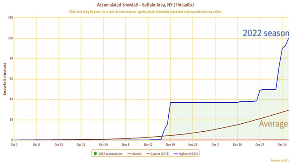 Seasonal snowfall-to-date in Buffalo, New York, through Dec. 26, 2022 (blue line), compared to average (brown line).
 The three snowstorms that have hammered Buffalo (and other lake-effect snowbelts) from mid-November through late December 2022).