Jonathan Erdman
Buffalo, New York, has already picked up over 100 inches of snowfall this season, a record pace for the snow-prone city, due to a trio of storms since mid-November.
The Christmas blizzard dumped up to 51 inches of snow in the Buffalo metro area and buried roads, trapped motorists and shut down the city's airport.
(NEWS: Latest On Buffalo Impacts)
As of late Tuesday night, the official observation at Buffalo-Niagara International Airport tallied 101.6 inches of snow so far this season.
That's Buffalo's snowiest start to any season by over a foot in records dating to 1884. The previous record snowiest "fall through Dec. 27" start to the season was 88.2 inches in 2000, according to data from NOAA.
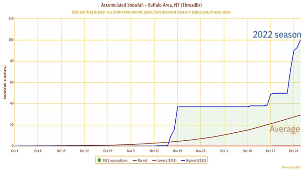 Seasonal snowfall-to-date in Buffalo, New York, through Dec. 26, 2022 (blue line), compared to average (brown line).
But doesn't Buffalo always get buried in lake-effect snow?
Not to this extent.
Their average season-to-date snowfall through Dec. 27 is only 30.2 inches. That means they've picked up over 71 inches more snow than average so far this season. It's also more than their entire season's average of 95.4 inches.
In fact, their snowfall surplus (again, over 71 inches) is greater than an average full season's snowfall in Portland, Maine (68.7 inches), Great Falls, Montana (66.1 inches), and Cheyenne, Wyoming (62.9 inches).
Three Storms And An Open Lake
Buffalo piled up this 100-inch-plus snow total from three separate storms in only six weeks.
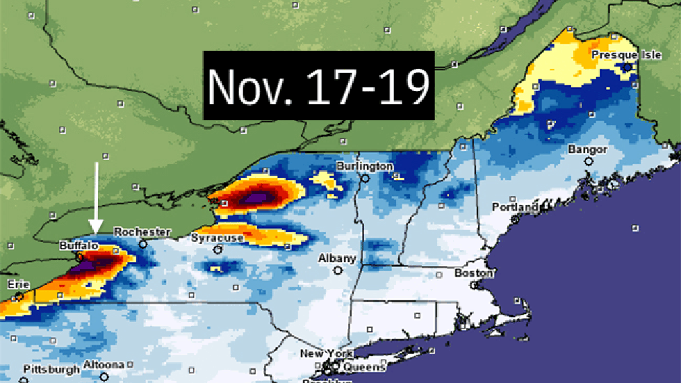 The three snowstorms that have hammered Buffalo (and other lake-effect snowbelts) from mid-November through late December 2022).
First came the November snowstorm that dumped up to 81 inches of snow in the metro area the week before Thanksgiving.
About a month later, Winter Storm Diaz dumped feet of snow in the Plains and Rockies, but also managed to squeeze out about a foot of snow in Buffalo in its cold wake.
One week after that, Winter Storm Elliott became a bomb cyclone and pulled much colder air over Lake Erie, producing whiteout conditions and a lake snow band that waffled over the city for almost 72 hours.
Weather historian Christopher Burt pointed out the Christmas blizzard (22.3 inches on Dec. 23, then 17.9 inches the following day) and mid-November (21.5 inches on Nov. 19) snowstorm produced three of the 13 heaviest calendar-day snowfalls on record in Buffalo.
These three snowstorms were generated by the perfect mix of a relatively ice-free Lake Erie with near-average water temperatures and a steady flow of cold air on southwest winds over the eastern Great Lakes.
A Break, Finally
Fortunately, the snowy pattern is ending.
Warmer air is headed into western New York. That includes highs in the 40s, even 50s, with some morning lows remaining near or above freezing into the first week of January.
There is a threat of rain into next week, but amounts appear to be on the light side to raise widespread, serious flood concerns.
However, in a Tuesday morning forecast discussion, the National Weather Service did mention the gradual melting of snow could lead to some basement flooding in the coming days.
The Weather Company’s primary journalistic mission is to report on breaking weather news, the environment and the importance of science to our lives. This story does not necessarily represent the position of our parent company, IBM.
The Weather Company’s primary journalistic mission is to report on breaking weather news, the environment and the importance of science to our lives. This story does not necessarily represent the position of our parent company, IBM.


No comments:
Post a Comment