weather.com meteorologists

The first freeze of the season may be here before you know it.
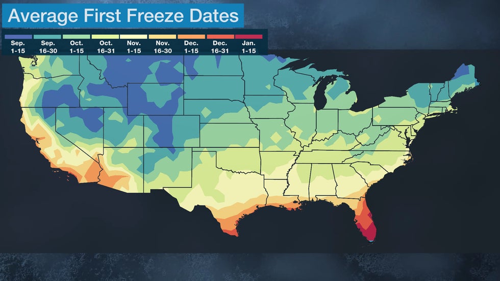
But when does the first freeze typically occur? Below, we'll break it down by the approximate average date. This is calculated by taking an average of the first freeze dates over a 30-year period from 1991 through 2020.
Keep in mind, however, that these are average dates. Different weather conditions each year can make the first freeze occur earlier or later than what is shown in a given region.
September
The average first freeze occurs by about Sept. 15 for much of the Rockies and parts of the Intermountain West, as well as parts of the northern Plains closer to the Canadian border.
The higher peaks of Maine's Mahoosuc Range, New Hampshire's White Mountains, Vermont's Green Mountains and New York's Adirondack Mountains drop to the freezing mark around Sept. 15 as well.
By the end of the month, a large swath of the Great Basin, High Plains, Northern Plains and northern Great Lakes have seen their first freeze.
Most of the Adirondacks and Catskills in New York experience 32-degree temperatures around Sept. 30.
The majority of New England also gets its first freeze by the end of September on average. The exception is areas closer to the coast, where it doesn't happen until a couple of weeks later.
October
Parts of northern Arizona and New Mexico have a first freeze around Oct. 1 over the highest elevations, while lower elevations could take a few extra weeks.
Parts of the Southwest into much of the central Plains and Ohio Valley as well as the Northeast generally reach 32 degrees around mid-October.
The Great Smoky Mountains in eastern Tennessee and western North Carolina also have their first freeze near mid-October, as well as the Shenandoah Valley of western Virginia and much of West Virginia.
(MORE: October Temperature Outlook)
November Or Later
Parts of the Southwest, southern Plains, mid-Mississippi and Ohio Valleys, and mid-Atlantic don't see their first freeze, on average, until Nov. 1.
That includes New York City, Philadelphia, Baltimore and Washington, D.C., due to the urban heat island effect, keeping cities warmer than their suburbs overnight.
Parts of California, the Southwest, southern Plains, lower Mississippi Valley and Southeast don't see their first freeze until around Nov. 15, on average.
In the southernmost portions of these regions, such as southeastern Texas into southern Alabama and the coastal Carolinas, southern Georgia and all of Florida, it may be December or January before it reaches 32 degrees, if at all.
The Weather Company’s primary journalistic mission is to report on breaking weather news, the environment and the importance of science to our lives. This story does not necessarily represent the position of our parent company, IBM.
The Weather Company’s primary journalistic mission is to report on breaking weather news, the environment and the importance of science to our lives. This story does not necessarily represent the position of our parent company, IBM.

No comments:
Post a Comment