weather.com meteorologists
More locally heavy rain is expected in flood-ravaged Vermont, New York and other parts of the Northeast this weekend, with the potential to trigger more flash flooding.
Sunday and Monday, up to 9 inches of rain soaked the Northeast, leading to over 300 reports of flash flooding from North Carolina to New Hampshire. Roads were washed out, some homes flooded and some towns were isolated. Parts of Vermont saw flooding of the magnitude not seen since Tropical Storm Irene in 2011 or the Great Flood of 1927.
(MORE: New York, Vermont Flood Recap)
Here's the timing of the rain. Following Thursday and Friday's rounds of thunderstorms, a significant bump in the chance of thunderstorms with heavy rain is expected Sunday.
Additional showers and storms are possible again by Tuesday, as another system moves through the region.
Flood watches are in effect: The National Weather Service has issued flood watches again for parts of the Northeast. This means additional flash flooding is possible from locally heavy rain.

Sunday to be wetter. A new round of storms is expected by early Sunday that could last for much of the day. Heavier rain is expected with initial thunderstorms.

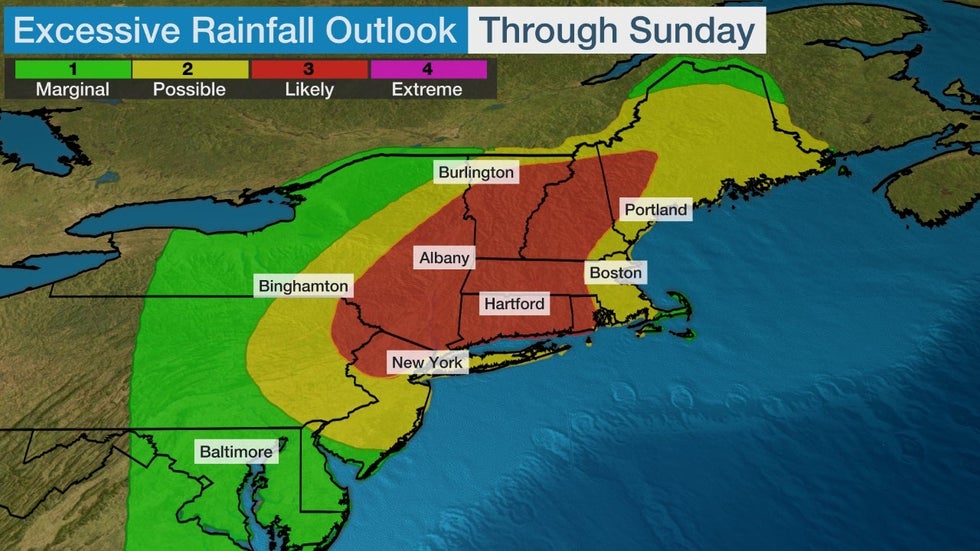
How much more rain could fall: These showers and storms through the weekend could dump locally heavy rainfall in parts of the Northeast. Upward of 3" of rain is possible.
 Rainfall Outlook
Given ground saturated by the recent torrential rain, and rain that also fell earlier this month, this could easily trigger additional flash flooding.
NOAA's Weather Prediction Center has highlighted parts of New York, New Jersey, Pennsylvania and New England with a threat of numerous flash flooding events again.

Additional rain is possible Tuesday with a new system.
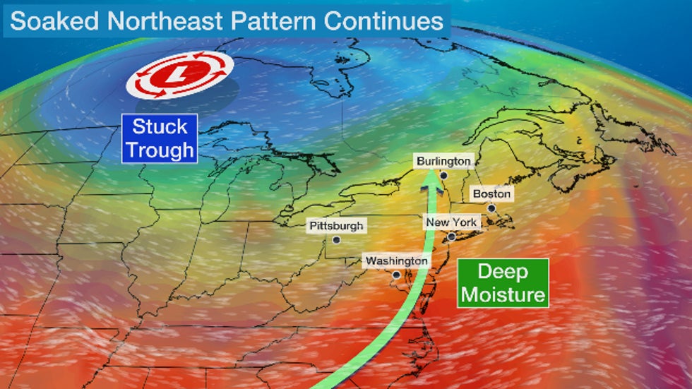
Why won't this rain let up: The simple answer to this is the atmospheric pattern is stuck.
That's because blocking high pressure aloft near Greenland is abnormally strong for summer.
That "Greenland block" is keeping a large, spinning gyre of low pressure in place over central Canada into early next week.
Disturbances embedded in the jet stream around the base of that Canadian low will continue to pull deep moisture into the Northeast. Those ingredients will trigger the showers and thunderstorms with locally heavy rainfall we alluded to above.

So, remain aware of the danger of flash flooding in the days ahead. We have safety tips both before and during a flash flood here.
The Weather Company’s primary journalistic mission is to report on breaking weather news, the environment and the importance of science to our lives. This story does not necessarily represent the position of our parent company, IBM.
The Weather Company’s primary journalistic mission is to report on breaking weather news, the environment and the importance of science to our lives. This story does not necessarily represent the position of our parent company, IBM.

No comments:
Post a Comment