Chris, Dolce, Linda Lam and Jon Erdman
July naturally brings to mind sweltering temperatures since it's midsummer, but hurricane season is also beginning its upward swing in activity and thunderstorms can be problematic in many parts of the country.
Here are five things we typically see in July's weather.
1. The Hottest Time Of Year For Many
July is the hottest month on average for an expansive part of the United States from the Great Basin to the Central Rockies, Central Plains, Midwest and East.
The sun is highest in the sky and delivers its most direct solar radiation over the Northern Hemisphere at the summer solstice in late June, but it takes days or weeks to warm up the Earth's surface and then the air above it. That means there's a lag between the solstice and the hottest day of the year.
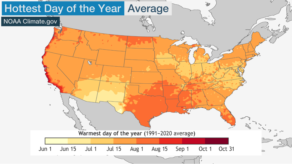 This map shows when the hottest time of year is, on average, across the Lower 48 states.
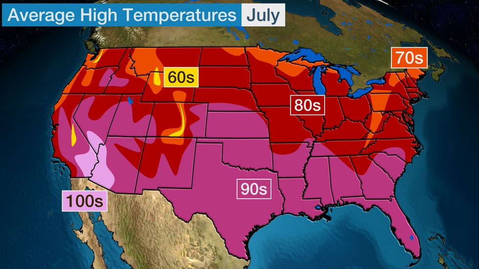
Highs in July are typically in the 80s and 90s for much of the contiguous U.S., with 70s in some locations closer to the Canadian border, along the Northwest coast and in the Rockies. Average highs in the 100s are typical in portions of the Desert Southwest in July.
2. Atlantic Hurricane Season Activity Begins To Tick Up A Bit
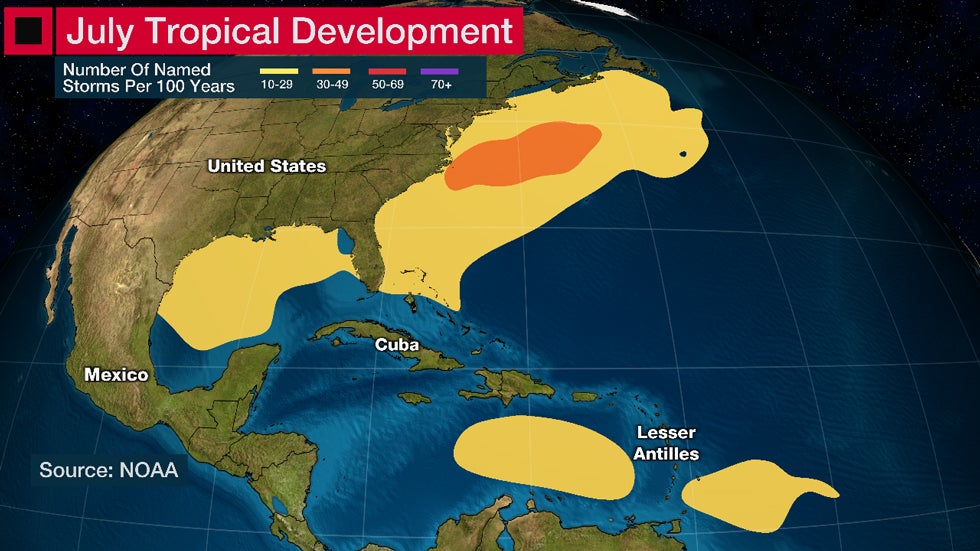
Hurricane season is usually still slow in July, but there is a slight uptick in activity and the areas of typical formation expand.
The southwestern Atlantic Ocean and eastern Caribbean Sea near the Lesser Antilles join the Gulf of Mexico and East Coast waters as favored areas for tropical development. Of course, the start of this season has been odd since June had two named storms – Bret and Cindy – form east of the Lesser Antilles, which is a rarity for the month.
July has accounted for about 7% of the hurricane season's tropical storms since 1851, which means roughly one named storm forms in the month each year. Hurricanes are more rare with about one of those forming every three years.
Last year had two named storms develop in July, but the month has seen zero storms track through the Atlantic Basin as recently as 2016.
(MORE: What To Expect From Hurricane Season In July)
3. Severe Thunderstorm Threat Peaks In The Northeast
The jet stream migrates to the northern tier of the U.S. by July and is weaker than what we usually see in winter and spring. But since hot, humid air is so abundant in midsummer, it's easier for thunderstorms to form when even weaker disturbances ripple through the jet stream.
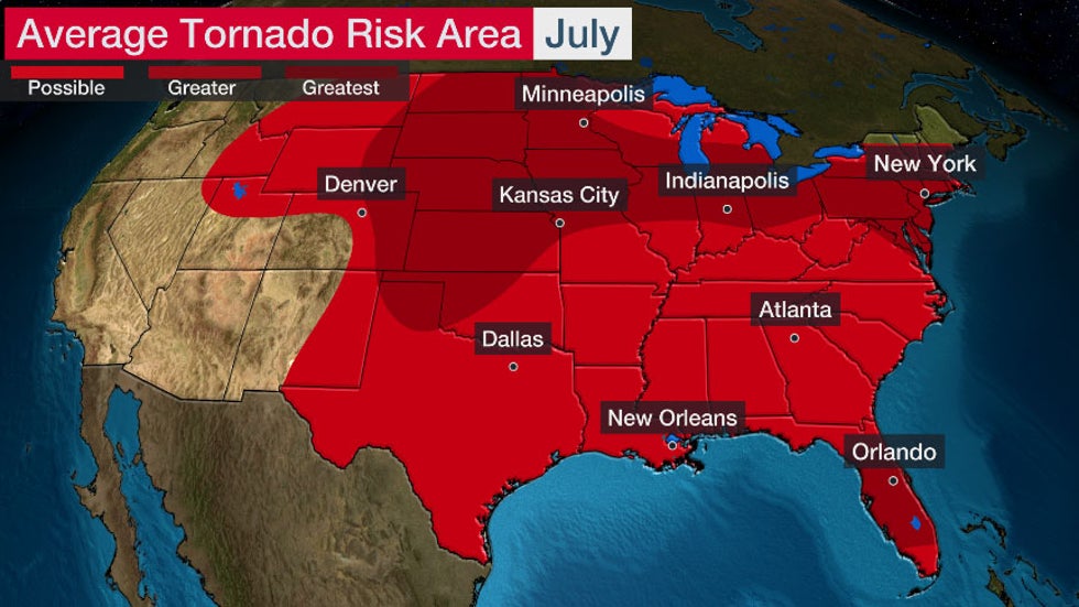
For this reason, areas from Northeast westward through the Great Lakes and Plains are a favored corridor for concentrated severe weather in July.
The Northeast averages the greatest number of severe thunderstorm reports in July, according to a study by NOAA's Storm Prediction Center. This includes areas around Boston, New York City, Philadelphia and Washington, D.C. This severe weather peak also holds true in parts of the Great Lakes, Northern Plains and northern Rockies.
Severe thunderstorms often take the form of squall lines with damaging straight-line wind gusts in midsummer instead of the tornadoes that dominate the spring. The number of tornadoes in the U.S. is cut almost in half from June (187) to July (101), but July is still typically the fourth most active month for tornadoes.
4. Southwest Monsoon Ramps Up
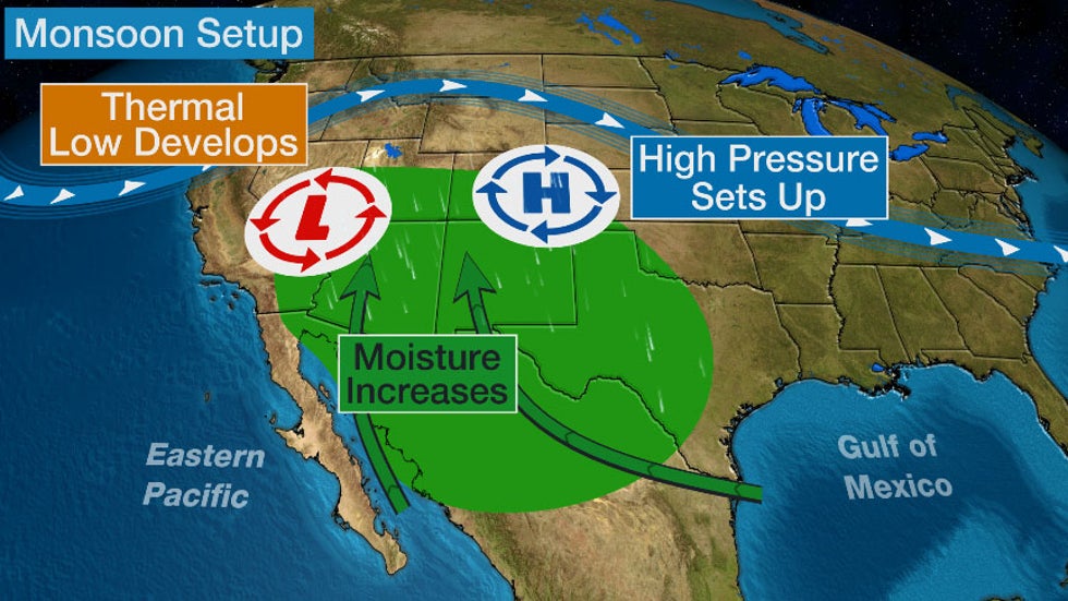
The Desert Southwest monsoon usually switches into its wet phase by July.
When a dome of high pressure aloft builds over the southern Rockies or adjacent Plains, moisture flows northward from the Gulf of California, the Eastern Pacific Ocean and westward from the Gulf of Mexico. This kicks off what can be a daily ritual of mainly afternoon and evening thunderstorms over the higher terrain over the Southwest.
Near the beginning of the monsoon's wet phase in July, when moisture isn't as plentiful, these thunderstorms may produce more wind than rain, whipping up an intense dust storm known as a haboob.
Heavy rain and flooding can occur in the desert later in the summer, particularly when moisture from a remnant of an Eastern Pacific tropical system flows into the region. Increased humidity at times can take away the common "dry heat" cliché.
The monsoon also fluctuates in how active it is from year to year. For example, 2020 was the driest monsoon on record for much of the Southwest. That was followed by one of the wettest monsoons in 2021, and another wetter than usual monsoon last year.
5. Thunderstorm Clusters Are Common
Any national radar loop on a July morning will probably show at least one cluster of thunderstorms known as mesoscale convective systems.
Their appearance in satellite imagery is particularly dramatic, often resembling a sunny-side-up egg covering parts of one or more states.
A 2019 study found July is one of two peak months for these batches of thunderstorms, which often rumble through the Plains and Midwest.
When these clusters of thunderstorms are fast-moving, they can produce widespread damaging winds known as a derecho. If they stall, flooding rainfall is often the result. Either way, they're usually prolific lightning producers, sometimes at a rate of several thousand strikes per hour.
The Weather Company’s primary journalistic mission is to report on breaking weather news, the environment and the importance of science to our lives. This story does not necessarily represent the position of our parent company, IBM.
The Weather Company’s primary journalistic mission is to report on breaking weather news, the environment and the importance of science to our lives. This story does not necessarily represent the position of our parent company, IBM.

No comments:
Post a Comment