Linda Lam
February brings a variety of weather, including snow, tornadoes and big temperature changes, as signs of spring begin to emerge.
Even if wintry weather dominates the month, the increased daylight becomes more noticeable and serves as a reminder that spring is coming. Here's more of what's typical in the month ahead:
Powerful Systems Can Bring Heavy Snow, Rain
Snow still piles up in February; It's the snowiest month of the year in some locations, including Tahoe City in California's Sierra Nevada Mountains, where about 41 inches typically falls during the month.
Many major Northeast snowstorms occur in February. It's the snowiest month in New York City (average of 10.1 inches) and Washington, D.C. (5 inches), while it is the second-snowiest month in Boston (14.4 inches). In February 2015, Boston totaled 64.8 inches, making it the snowiest month on record and a big reason why the city set its record for the snowiest season that year.
(MORE: Here's Our February-April Temperature Outlook)
February can also bring a giant mess to the rest of the country, including ice storms as cold air rides over pockets of warm and rainy weather across the South.
In 2022, Winter Storm Landon brought a stripe of snow and ice that encompassed about one-third of Americans from New Mexico to New England.
Although Dallas and Seattle don't receive a lot of snow, February is the snowiest month in both cities. Dallas measured 13.5 inches in February 1978, while the snowiest February in Seattle was in 1916, when 35.4 inches of snow fell.
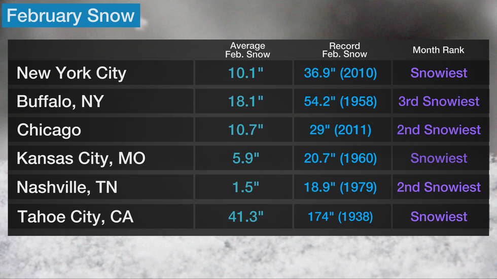 February snowfall in select cities. Average snowfall is based on 1991-2020 data.
Numerous records were set for the snowiest February in 2019. Minneapolis/St. Paul smashed its snowiest February record by over a foot, tallying 39 inches of snow. Eau Claire, Wisconsin, picked up 53.7 inches in February 2019, nearly doubling their previous record for the month.
In late February 2019, Winter Storm Quiana brought snow to Las Vegas for the first time in over 10 years and set an all-time calendar-day record snowfall in Flagstaff, Arizona. As this system tracked eastward, blizzard conditions were reported in parts of the Plains and upper Midwest.
No location was snowier in February 2019 than California's Sierra Nevada. Mammoth Mountain was buried by 207 inches of snow, or more than 17 feet, which was the highest February total at the ski area since records began in 1970.
Heavy rain and snow are not uncommon in California in February, which is typically the wettest month of the year in much of Southern California, including in Los Angeles and San Diego.
Temperatures Rise During February
The heart of winter has passed for most of the United States as February begins. For most locations east of the Mississippi River, the coldest time of year is in January, while much of the West receives the coldest temperatures in December.
Average high temperatures in February begin to warm slightly but remain chilly overall. Average highs in the teens become more confined to northern North Dakota and northwestern Minnesota, while 60s expand farther north into more of the South and into parts of Central California. Average highs in the 70s return to parts of the Southwest.
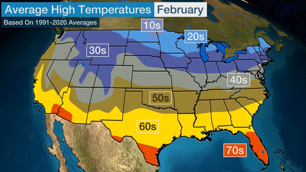
More signs of spring begin to emerge due to these warmer temperatures, including flowers blooming in some areas. However, low temperatures can drop below freezing for much of the country, so any early blooms need to be cared for during freezes.
Average low temperatures are in the single digits above or below zero in parts of the Northern Plains and upper Midwest in February. Average lows in the 50s return to Florida and coastal Texas.
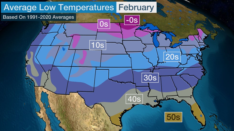
February can still be bitterly cold, as we saw four years ago. Rapid City, South Dakota, saw its coldest February on record and had 20 days of low temperatures of zero or colder, with temperatures plummeting as low as minus 19 degrees. Billings, Montana, set a February record, dipping to zero or colder on 19 of 28 days.
February 2021 saw dozens of all-time record lows set in the Plains and about a week of below-freezing temperatures in some spots that typically only see smaller spurts of freezing weather, like Oklahoma City.
Conversely, February 2018 had numerous warm temperature records tied or set from the South to the Northeast. Temperatures soared to 78 degrees in New York City on Feb. 21, 2018, topping the previous February record of 75. Washington, D.C., recorded its earliest 80-degree day with a high of 82 on Feb. 21. Several cities across the South experienced their warmest February on record, including New Orleans, Atlanta and Tampa.
Tornado Risk Area Expands
The area at higher risk for tornadoes grows from January to February as temperatures increase and the jet stream begins to shift. Moisture from the Gulf of Mexico can surge northward as low-pressure systems track eastward across the U.S.
Portions of the South are at an elevated risk for severe thunderstorms and tornadoes due to the proximity to the Gulf of Mexico.
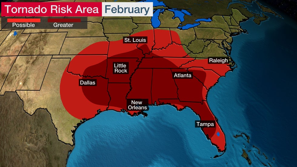
Based on data from 2008 to 2022 from NOAA's Storm Prediction Center, an average of 46 tornadoes occur each February. Texas, Mississippi, Alabama and Florida experience the highest number, with an average of three tornadoes each. This is a relatively small number compared to the spring and summer months.
However, there is a lot of variation from year to year. In 2008, the U.S. had 147 confirmed February tornadoes, and there were 59 deaths from those storms. Winter tornadoes can be particularly dangerous since they are often fast-moving and hard to see (rain-wrapped and/or occurring at night).
Flooding can also be a problem in the South during February. In fact, both 2019 and 2020 went into the record books as record-wet Februaries in a few cities.
Daylight Increases
An increase in daylight can be counted on as the darkness of winter begins to lift, regardless of the weather pattern that sets up in February.
Much of the U.S. sees about an hour of additional daylight from the beginning of February until the end of the month.
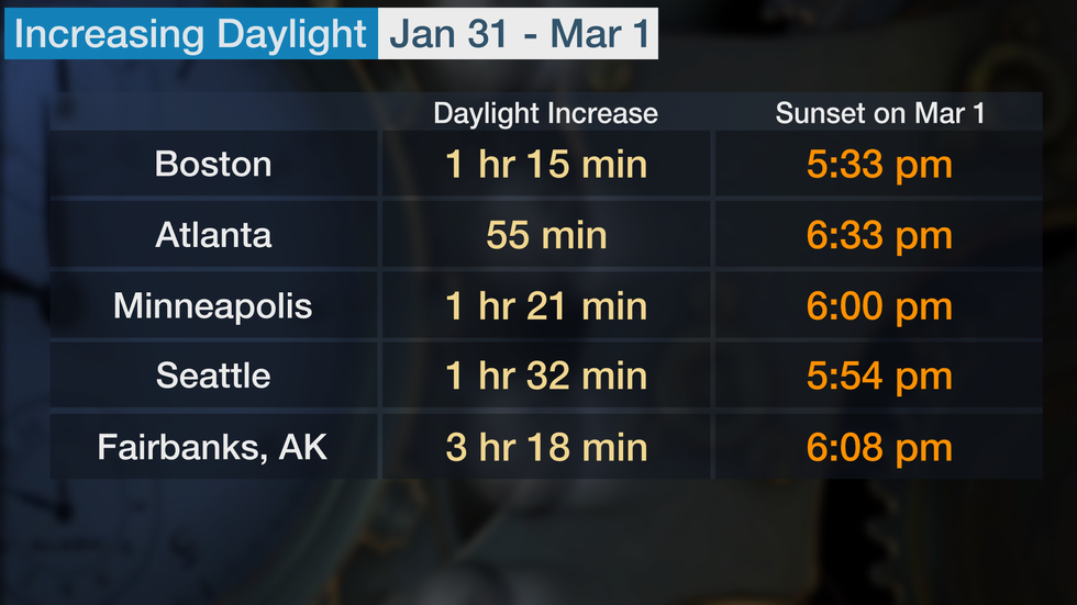
Areas farther north experience the largest increase. The Northeast and Midwest see about an hour and 15 minutes more daylight by March 1 compared to the end of January, while the Pacific Northwest sees an increase closer to an hour and a half.
The increase in daylight is an average of 40 to 50 minutes across the southern tier of the Lower 48. However, farther north in Alaska, Fairbanks experiences an increase in daylight of more than 3 hours.
The Weather Company’s primary journalistic mission is to report on breaking weather news, the environment and the importance of science to our lives. This story does not necessarily represent the position of our parent company, IBM.
The Weather Company’s primary journalistic mission is to report on breaking weather news, the environment and the importance of science to our lives. This story does not necessarily represent the position of our parent company, IBM.

No comments:
Post a Comment