Jonathan Belles
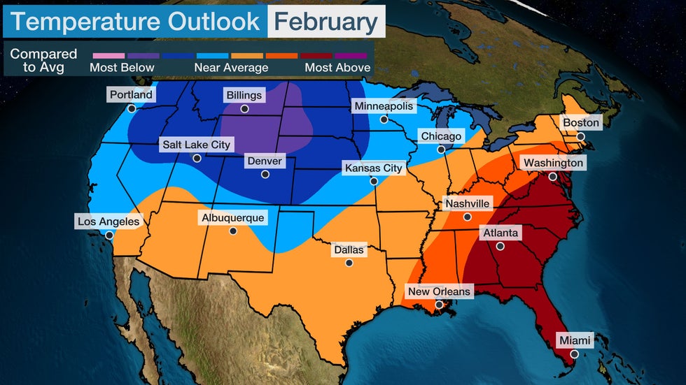
A colder start to February across the Lower 48 might give way to slightly warmer conditions, especially across the East and South.
The bulk of the colder air should settle into the North and Northwest in the month ahead, while the snowbirds will be happy with their trips to the warmer-than-average Southeast and South, according to an outlook released Sunday by The Weather Company, an IBM Business, and Atmospheric G2.
This outlook has trended colder in parts of the Northern Plains while trending warmer in the Southwest, Florida and parts of the mid-Atlantic, compared to the previous outlook released earlier in January.

The first week could be rather chilly across the West and North, but that should moderate.
"The cold spells over the last few months haven't lasted more than a couple of weeks, so there is no reason to think the upcoming (into early February) cold spell will be different," said Todd Crawford, Vice President of Meteorology at Atmospheric G2.
"We expect the final three weeks of the month to be warmer than normal on [a] national [scale] with the cold generally confined to the western half of the U.S.," Crawford added.
This February may be reminiscent of last February, albeit a bit warmer, which also had colder temperatures in the Central U.S. and modestly warmer temperatures on the East Coast.
La Niña Lingers, Weighs Heavy On The Outlook
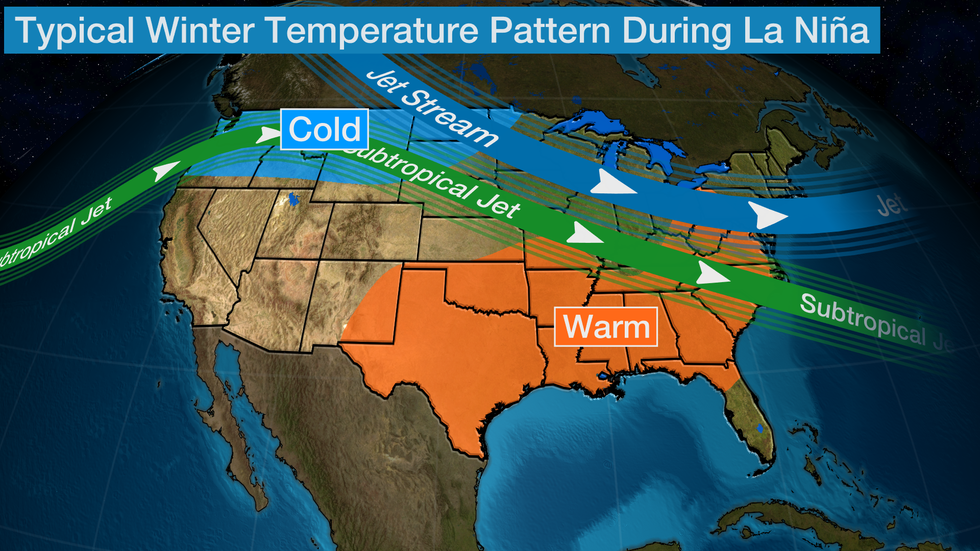
Despite a trend toward warmer Pacific waters later this year, La Niña is still in place this winter for a rare third straight year.
La Niña is the periodic cooling of the equatorial eastern and central Pacific Ocean, and the interaction of this cooler-than-average water with the atmosphere can affect weather conditions around the globe.
Over the last 10 La Niña Februaries, temperatures have been warmest relative to average along the East Coast. Temperatures have been coolest in the northern High Plains in those 10 months while being cooler than average throughout the remainder of the Plains and West.

Crawford also said the atmospheric response to La Niña remains relatively weak, which means more variability in this pattern is possible.
Finally, what happened to the sudden stratospheric warming (SSW) and the weakening of the polar vortex that we mentioned last week?
"The potential SSW appears to have been a dud, as the current minor stratospheric warming does not appear to have legs, nor any significant downward influence on the troposphere," Crawford wrote.
The Weather Company’s primary journalistic mission is to report on breaking weather news, the environment and the importance of science to our lives. This story does not necessarily represent the position of our parent company, IBM.
The Weather Company’s primary journalistic mission is to report on breaking weather news, the environment and the importance of science to our lives. This story does not necessarily represent the position of our parent company, IBM.

No comments:
Post a Comment