Chris Dolce
A bomb cyclone has become an increasingly common phrase used in the winter to describe powerful low-pressure systems that intensify rapidly and are often accompanied by heavy snow and strong winds.
You might think this term was made up to capture the public's attention, but it actually has its roots in meteorology.
It originated from bombogenesis
The term "bomb cyclone" came from the meteorological term "bombogenesis," which refers to the central pressure of a low-pressure system dropping at least 24 millibars within 24 hours. You can even find it defined as this in the American Meteorological Society glossary.
Simply put, this means a storm is intensifying quickly, which can result in more severe impacts than what a weaker storm would produce.
 A satellite view of Winter Storm Grayson after it became a bomb cyclone along the East Coast in January 2018.
Bomb cyclones aren't common, but also not rare
A 2021 study led by Robert Fritzen from Northern Illinois University found about 7% of all nontropical low-pressure systems near North America from 1979 to 2019 were bomb cyclones. That amounted to about 18 bomb cyclones per year, on average, near North America in that 40-year period.
They are most common in the East, but can happen elsewhere in the U.S.
The large majority of bomb cyclones occurred off the East Coast of the U.S., which averaged one such bomb cyclone per year.
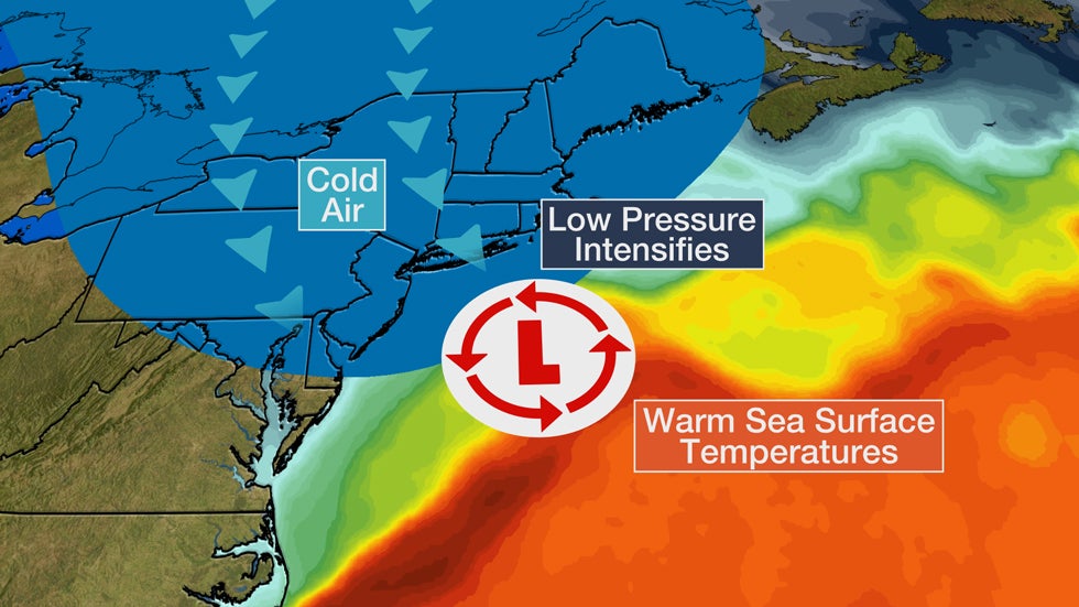
In the Northeast, bombogenesis results when there is a large temperature gradient, usually between a cold continental air mass and warm sea-surface temperatures in the Atlantic.
Over that temperature contrast, a powerful, intensifying jet-stream disturbance forces air to rise, kicking off the bombogenesis process.
Frequently, nor'easters are bomb cyclones due to cold air surging southward from Canada combined with the warm ocean waters of the Gulf Stream.
While bomb cyclones happen most often near the East Coast, they can occur in other regions like the central U.S. A bomb cyclone even hit the West Coast in fall 2021.
Bomb cyclones typically form in colder months
These intense storms are most common from October through March, but they can happen any time of year.
That goes back to these storms getting their fuel from the temperature contrast and aforementioned powerful jet stream disturbances. Both of those ingredients are more common in the cooler months.
What a bomb cyclone can mean for a storm's impact
Winds increase dramatically, and precipitation, including snowfall, can become intense. Blizzard conditions can occur, sometimes accompanied by lightning as the system is bombing out.
Wind gusts often exceed 50 mph, particularly over open country and near the coastlines of the East Coast and Great Lakes. These strong gusts can down trees, knock out power and push water ashore, leading to coastal and lakeshore flooding.
Notable bomb cyclone examples from the past
-In early March 2018, the first of the so-called four-easters, Winter Storm Riley bombed out off the East Coast and drove destructive coastal flooding into parts of the Eastern Seaboard.
-Two months prior, in early January 2018, Winter Storm Grayson intensified at the most rapid rate on record for the western Atlantic Ocean, plunging roughly 59 millibars in 24 hours to a low of 950 mb.
-In February 2013, Winter Storm Nemo dropped 29 mb within a span of 24 hours (specifically, a barometric pressure of 1,000 mb was recorded at 4 a.m. on Feb. 8, and it dropped to 971 mb at 4 a.m. on Feb. 9). Winter Storm Nemo ultimately "bottomed out" with a minimum barometric pressure reading of 968 mb at 4 p.m. on Feb. 9. This powerful low-pressure system resulted in a wind gust of 83 mph near Cuttyhunk, Massachusetts, and thundersnow was reported on Long Island.
-An example of bombogenesis over land was the "Octobomb" that impacted portions of the Plains and Midwest Oct. 25-27, 2010. All-time record-low barometric pressure readings were set by this system in Minnesota and Wisconsin.
-Another major bomb cyclone that happened over the nation's midsection was in March 2019. That system was named Winter Storm Ulmer, and it brought heavy snow, flooding rain and damaging winds to the Plains.
 A color-enhanced water vapor satellite image of the Plains bomb cyclone - Winter Storm Ulmer - at peak intensity on March 13, 2019.
The Weather Company’s primary journalistic mission is to report on breaking weather news, the environment and the importance of science to our lives. This story does not necessarily represent the position of our parent company, IBM.
The Weather Company’s primary journalistic mission is to report on breaking weather news, the environment and the importance of science to our lives. This story does not necessarily represent the position of our parent company, IBM.


No comments:
Post a Comment