weather.com meteorologists
You can track Ian here or sign up for the Morning Brief email newsletter to get weekday updates from The Weather Channel and our meteorologists.
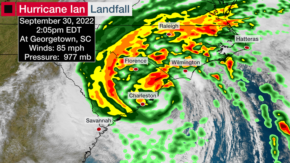
Ian is now moving inland across the Carolinas after making its final landfall near Georgetown, South Carolina. It will continue to pack threats of flooding rain, strong winds and isolated tornadoes from the Carolinas into parts of Virginia.
(MORE: Latest Updates Page)
Latest Status
Ian is now a tropical storm strength system moving northward through the Carolinas.
Gusty winds, heavy rainfall and a few tornadoes will continue into Saturday from the Appalachians to the mid-Atlantic.

From there, it will weaken to a remnant area of low pressure on Saturday.
Forecast Impacts
Wind Threat
Power outages and some tree damage could occur in across the mid-Atlantic, Carolinas and in the Appalachians as Ian moves inland.
Trees will also be more easily downed given the ground will be soaked by heavy rain.
Rainfall, River Flooding
Heavy rainfall is another dangerous threat from the Carolinas into Virginia and the Appalachians.
The heavy rain in these areas could trigger flash flooding and river flooding. Farther south, major to record river flooding is expected to continue in parts of Florida into early next week.
 Rainfall Forecast
Hurricane Ian History and Statistics
Ian's beginnings came from a tropical wave in the Atlantic that fought hard against dry air and wind shear caused by Hurricane Fiona.
Eventually, it became a major hurricane near western Cuba before bringing its extreme winds and storm surge to Florida.

Ian's U.S. Landfalls
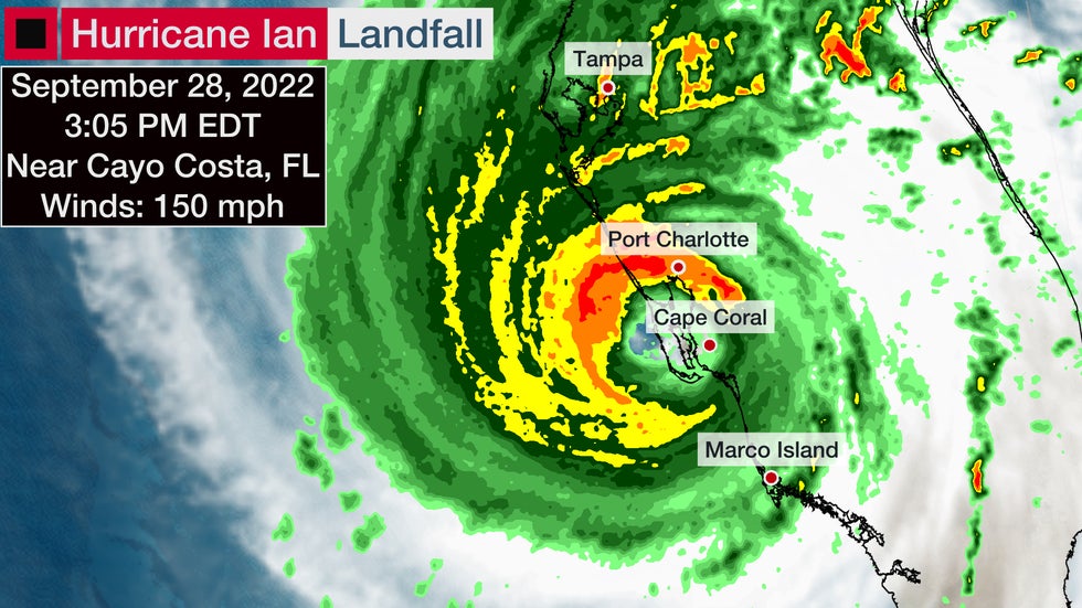
The eye of Ian made its first landfall near Cayo Costa around 3:05 p.m. EDT. Maximum sustained winds were estimated to be near 150 mph, making it a strong Category 4.

This is the exact same point where Hurricane Charley made landfall in 2004 as a Category 4. Both hurricanes had winds of 150 mph at landfall.
Hurricane Ian made a second U.S. landfall at 4:35 p.m. in Pirate Harbor, or just south of Punta Gorda, with maximum sustained winds of 145 mph.
This landfall is tied for the 4th strongest landfall by wind speed for a hurricane in Florida, according to Phil Klotzbach, tropical scientist at Colorado State University.
The backside of Ian's wrath continued to produce additional surge and wind damage in Southwest Florida for hours after landfall.
Hurricane Ian made its third and final U.S. landfall near Georgetown, South Carolina, on Sept. 30 with winds of 85 mph.

Wind
Winds gusted from 40 to 80 mph in Key West Tuesday into early Wednesday, where Ian also produced the third highest storm surge in over 100 years.
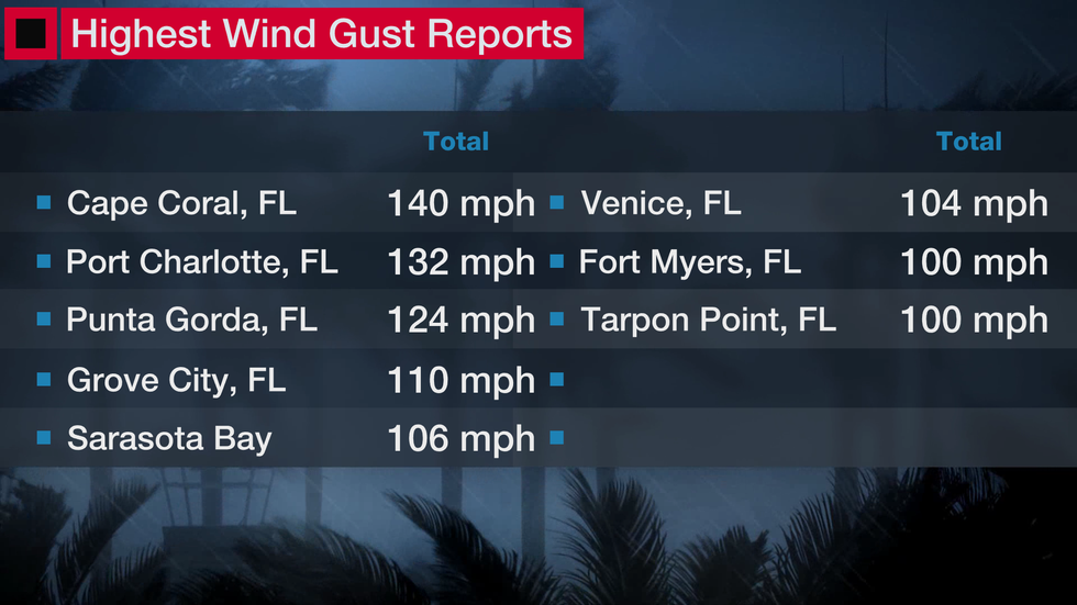
The highest wind gust was 140 mph in Cape Coral, Florida. The highest sustained winds reported were 115 mph at a private weather station near Port Charlotte, Florida. That station also recorded a wind gust of 132 mph.
Winds gusted over 100 mph in Punta Gorda, Florida, for 30 minutes in the 4 p.m. hour on Sept. 28 and continued to report wind gusts over 100 mph into the evening.
Here are some of the most significant gusts:

Additionally, winds gusted to 126 mph at Redfish Pass, 112 mph at the Naples Grande Beach Resort, and 107 mph near Sanibel Island.
Some gusts topped 70 mph in Northeast Florida on Thursday, including in Daytona Beach. Winds gusted to 89 mph at an elevated tower at Kennedy Space Center. Some gusts over 50 mph were clocked in Gainesville and Jacksonville, and over 30 mph gusts have worked their way along the coasts of Georgia and South Carolina.
On Sept. 30, an elevated WeatherFlow sensor near Charleston recently reported a 92 mph gust. Fort Sumter, South Carolina, measured a gust to 83 mph at 11 a.m. Friday. Folly Beach, South Carolina, has seen wind gusts up to 66 mph.
Wind gusts have been near 60 mph in Charleston, South Carolina, but high rainfall rates have created flooding.
Multiple roads have been closed because of flooding in the Charleston metro area, and the combination of storm surge.
Surge
Storm surge flooded many cities in Southwest Florida, including in Naples, Florida, where over 6 feet of storm surge inundation has been measured, more than any other storm at that gauge location in at least 50 years. The tidal gauge there has since broken.
Water levels are reaching the top of the first floor of homes in Fort Myers Beach during the eye of Hurricane Ian. This tweet shows the vantage point from the second floor in Fort Myers Beach:
In Fort Myers proper, however, storm surge was over 7 feet with high tide this evening. Previously the highest storm surge was 3.36 feet MHHW during Hurricane Gabrielle in 2001.
Meanwhile, winds are blowing offshore producing a blowout tide in Tampa Bay. Water levels are around 8 feet below average near the Port of Tampa and many parts of Tampa Bay were dry for much of Wednesday.
The combination of storm surge and rainfall around high tide sent feet of water into St. Augustine Thursday, with water reportedly entering homes, according to the National Weather Service. St. Augustine Fire Rescue reported water levels were higher in the city than seen during Hurricane Matthew in 2016.
In the Carolinas, water levels rose early on Friday, Sept. 30, along the northern South Carolina coast and into North Carolina.
Water levels were over 5 feet higher than usual in Myrtle Beach.
Significant storm surge flooding was also reported on Pawley's Island.
Rainfall
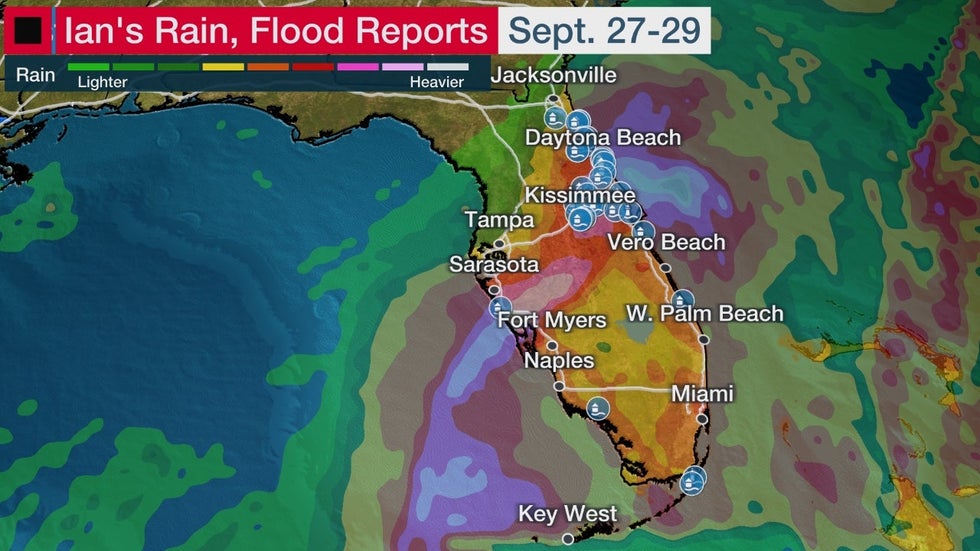
Extreme rain triggered major flooding in parts of central Florida, prompting a flash flood emergency for the north side of the Orlando metro area near the Little Wekiva River. Orlando shattered its all-time 24-hour rainfall record, picking up 12.49 inches from 8 a.m. Wednesday through 8 a.m. Thursday, according to weather historian, Christopher Burt. Up to 19 inches of rain has already fallen in parts of the state.
Here's a look at some of the flooding reports across Florida:

Heavy rain from Ian's track across Florida sent some rivers in the Florida Peninsula to major, even record flood levels. Widespread flooding occurred on Thursday, Sept. 29 in the greater Orlando metro area.
The Peace River topped a record crest from 1933 at Zolfo Springs, about 60 miles north of Ft. Myers. Record flooding was also recorded in the Little Wekiva River near Altamonte Springs on Orlando's north side, Shingle Creek at Campbell and Horse Creek near Arcadia, Florida.
More from weather.com:
12 Things You May Not Know About Your Hurricane Forecast
7 Things Florida Newcomers Should Know About Hurricane Season
The Florida Peninsula's Luck Since Hurricane Irma Won't Last
The Weather Company’s primary journalistic mission is to report on breaking weather news, the environment and the importance of science to our lives. This story does not necessarily represent the position of our parent company, IBM.
The Weather Company’s primary journalistic mission is to report on breaking weather news, the environment and the importance of science to our lives. This story does not necessarily represent the position of our parent company, IBM.

No comments:
Post a Comment