Chris Dolce and Jonathan Erdman
We've entered the time of year major Northeast U.S. snowstorms are most likely to occur, according to more than 60 years of government data.
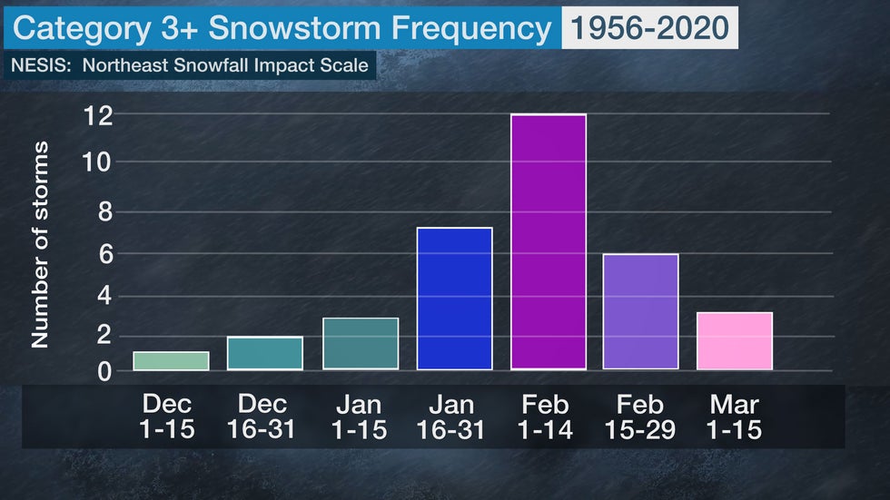
From 1956 to 2020, almost three-quarters of all Northeast snowstorms attaining a Category 3 or higher rating on the Northeast Snowfall Impact Scale (NESIS) have occurred in late January or February, according to NOAA's National Centers for Environmental Information.
Of the 34 such storms on that list, 25 of them have happened in late January or February. A dozen of those storms have occurred the first two weeks of February.
Two of the three highest NESIS-rated storms happened in early March, the clear front-runner being the Superstorm of March 12-14, 1993.
 The number of Category 3 or higher Northeast snowstorms for each two-week period from December through March, according to the NESIS scale.
In 2004, Paul Kocin, a National Weather Service meteorologist, and Dr. Louis Uccellini, the director of the National Weather Service, developed the scale to rank the impact of Northeast snowstorms based on snowfall amounts and the population affected.
In general, widespread heavy snowfall over highly populated areas produces a high NESIS value.
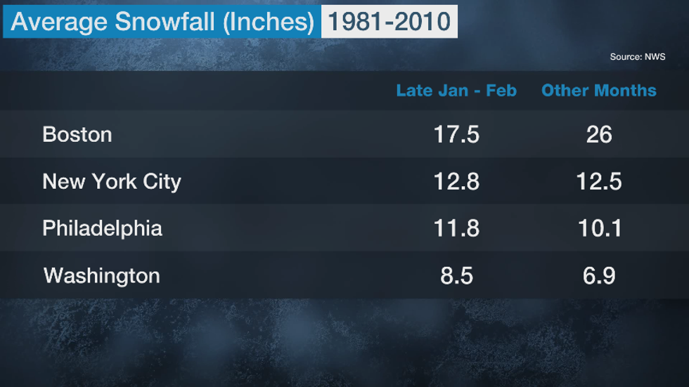
This peak in major Northeast snowstorms from late January through February also shows up in average snowfall data for the Boston-to-Washington corridor.
In a typical season, New York City, Philadelphia and Washington D.C. see at least a small majority of their seasonal snow from late January through February.

Some Notorious Examples
Here are just a few examples pointing out this Category 3 or higher Northeast snowstorm climatological bullseye over the past ten years or so.
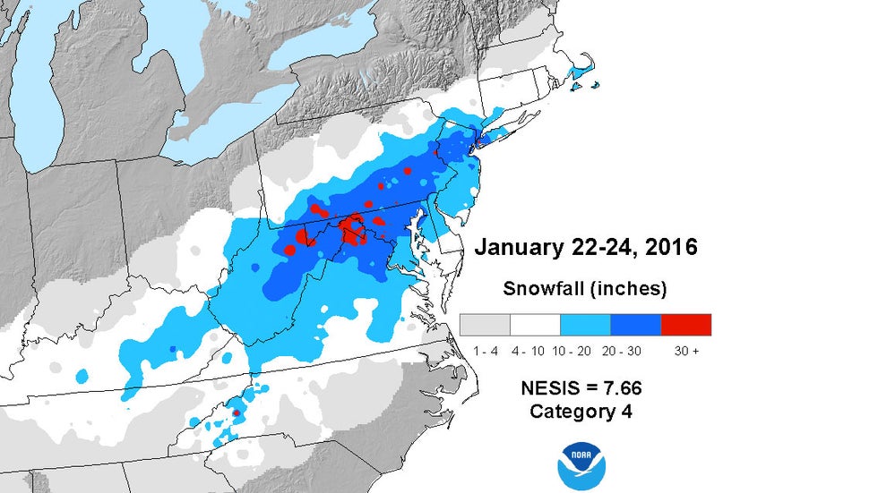
 NESIS snowfall analysis for Winter Storm Jonas which a was a Category 4.
- Late January 2016: Winter Storm Jonas was a record snowstorm for New York City, Baltimore and Harrisburg, Pennsylvania.
- Early February 2013: Winter Storm Nemo was a record snowstorm for Portland, Maine, and buried much of New England in multiple feet of snow.
- Early February 2010: Snowmageddon I and II hammered the Mid-Atlantic States just days apart. Hundreds of thousands were without power and some roof collapsed.
Here are a few other memorable late-January and February major Northeast snowstorms prior to the 2010s.
- February 2003: Presidents' Day II storm produced 4-inch-per-hour snowfall rates in Philadelphia; Reagan National, Baltimore-Washington, Philadelphia and LaGuardia airports closed; record Boston snowstorm.
- February 1983: "Megalopolitan Snowstorm" crippled the entire Northeast corridor with 2 to 5 inch per hour snow rates, accompanied by lightning.
- February 1979: The original Presidents' Day snowstorm hammers Washington D.C. and the Mid-Atlantic states.
- February 1978: The Northeast's Blizzard of '78 crippled southern New England, in particular.
- February 1969: A large swath of 20-inch-plus snow buried eastern and northern New England.
Why the Peak?
The peak for the occurrence of Northeast snowstorms has to do with several factors.
One of these is the supply of cold air.
"Typically, the lowest temperatures of the season in Eastern Canada and Northern New England occurs in late January through early February," said winter weather expert Tom Niziol.
Niziol also said from February into March, storm tracks associated with jet streams often begin to shift to a bit more southerly source region.
"When you combine these two factors, it matches up pretty well with the maximum of late January through early March for Northeast snowstorm occurrence."
The Weather Company’s primary journalistic mission is to report on breaking weather news, the environment and the importance of science to our lives. This story does not necessarily represent the position of our parent company, IBM.
The Weather Company’s primary journalistic mission is to report on breaking weather news, the environment and the importance of science to our lives. This story does not necessarily represent the position of our parent company, IBM.

No comments:
Post a Comment