Chris Dolce and Jonathan Erdman
The temperature pattern in February is expected to split the nation with the coldest conditions in the West as the East stays milder.
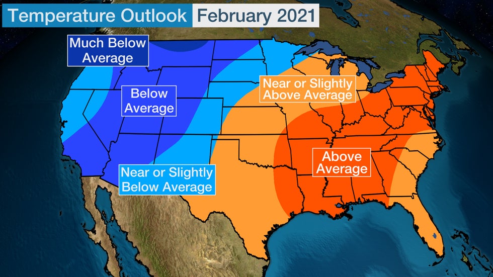
Above-average temperatures are most likely from parts of the South into the Ohio Valley and Northeast in February, according to the latest update from The Weather Company, an IBM Business. Temperatures are expected to be below average overall during the month from the Southwest into portions of the northern Rockies and northern Plains.
While the forecast is for milder-than-average temperatures to dominate the eastern states overall in February, there could still be periods of colder weather, based on the expected large-scale weather pattern.
February's Weather Pattern
Much of winter, so far, has been a relative non-event in parts of the northern U.S.
A persistently strong Pacific jet stream has spread warmer-than-average air into much of Canada and the northern states from the Northwest to the Plains, Great Lakes and New England.
Some cities like Grand Forks, North Dakota, and Caribou, Maine, have had a record-warm start to winter through Jan. 26, according to the Southeast Regional Climate Center.
But there are signs the pattern will be different in February.
 The general jet-stream level features expected to be in place in February.
One change is that a sharper southward jet stream plunge – known as a trough – could be the prominent weather feature in the western U.S., forced by a bubble of higher pressure aloft in the North Pacific Ocean poking north toward Alaska's Aleutian Islands.
The proximity of colder air in western Canada increases the chance of a colder February in parts of the West.
This pattern change, by itself, resembles a typical La Niña winter – namely, colder in the Northwest and northern Rockies, and generally warmer elsewhere in the U.S.
But there's one stubborn feature that could throw a large monkey wrench into that general La Niña outlook.
That's the Greenland block, another bubble of high pressure aloft near Greenland that intensified after Christmas. Meteorologists also refer to this as the negative phase of the North Atlantic Oscillation (NAO), a sloshing of pressure difference across the North Atlantic Ocean.
Dr. Todd Crawford, chief meteorologist with The Weather Company, suggested this blocking pattern may stick around at least through February, if not later, based on an examination of previous winters similarly dominated by it.
"We’re having our first winter in a decade with sustained downstream blocking (negative NAO), which, combined with the La Niña forcing, may allow for a few chunks of colder air from western Canada to move southeastward across the major population centers of the eastern U.S.," said Crawford.
In other words, it may temper, to some extent, what would otherwise be a warm late winter in parts of the South and East.
The Weather Company’s primary journalistic mission is to report on breaking weather news, the environment and the importance of science to our lives. This story does not necessarily represent the position of our parent company, IBM.
The Weather Company’s primary journalistic mission is to report on breaking weather news, the environment and the importance of science to our lives. This story does not necessarily represent the position of our parent company, IBM.


No comments:
Post a Comment