Chris Dolce
A prolonged bout of Santa Ana winds in Southern California is triggering another critically high wildfire danger amid tinder-dry conditions.
Periods of strong wind gusts are expected to last into at least Friday or Saturday in portions of Southern California. If any wildfires ignite the winds could allow them to spread rapidly through an environment that also has very dry vegetation and low humidity.
(MORE: Fire Danger Could Trigger Preventive Power Outages)
The National Weather Service (NWS) called this a "particularly dangerous situation" for the Los Angeles and Ventura County mountains and the Santa Clarita Valley. Thursday is expected to have the most severe wildfire danger in this area, the NWS said.
Red flags warnings for the fire danger have been issued by the NWS for most of Southern California. They go into effect late Wednesday and last into Friday or even Saturday in some areas.
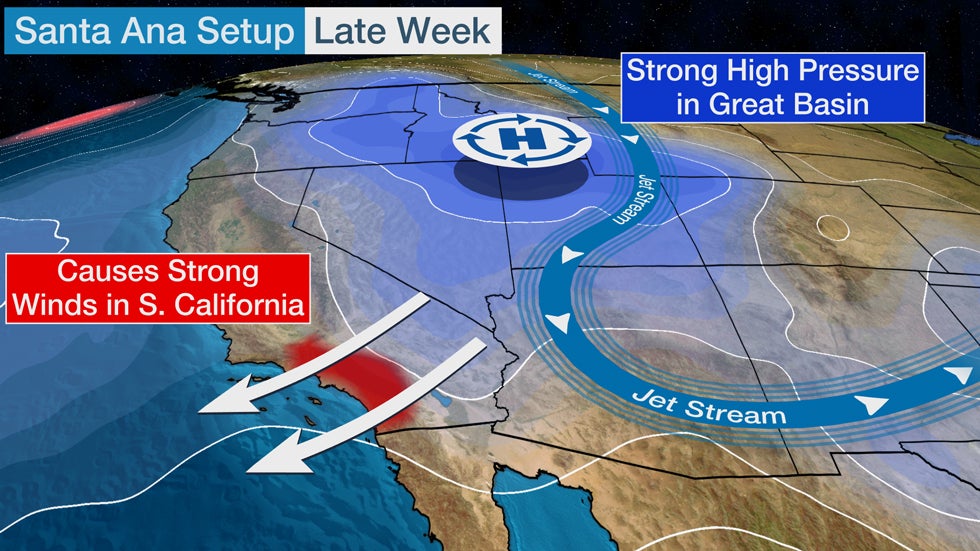
Santa Ana winds happen when an area of surface high pressure builds into the Great Basin and creates a large, anomalous pressure difference between the inland high and lower pressure near or off the coast.
The strength of the winds can be amplified when there is a southward plunge of the jet stream over the Southwest, as we are seeing late this week.
Santa Ana winds are most common from October through March, according to a 2017 climatology study, but can occur anytime from September into June.
The wildfire danger fueled by strong winds is typically highest in fall as the region emerges from the summer dry season when vegetation is driest.
Wildfire danger is often substantially reduced after the first significant rain and mountain snow event of the late fall and early winter arrives. That hasn't happened yet.
Since Oct. 1, rainfall in downtown Los Angeles is just 6% of average, or near a tenth of an inch. December, on average, is when the wintertime wet season ramps up substantially in Los Angeles and the rest of Southern California.
However, the chance of significant rainfall or mountain snow is expected to be slim into mid-December. Odds are tilted toward below-average precipitation in much of California through mid-December, according to the latest 8- to 14-day outlook from NOAA's Climate Prediction Center.
Any additional rounds of strong winds in Southern California will heighten wildfire danger until a weather pattern change opens the door for substantial precipitation to arrive in the region.
The Weather Company’s primary journalistic mission is to report on breaking weather news, the environment and the importance of science to our lives. This story does not necessarily represent the position of our parent company, IBM.
The Weather Company’s primary journalistic mission is to report on breaking weather news, the environment and the importance of science to our lives. This story does not necessarily represent the position of our parent company, IBM.


No comments:
Post a Comment