Linda Lam
Rain, snow and windy conditions will spread across parts of the West, Midwest, South and East this weekend as a low pressure system slides eastward.
A few severe thunderstorms may also be possible in parts of the South and East this weekend.
Happening Now
This system is currently crashing through the Northwest and West with strong winds and high-elevation snow.
Strong winds are expected in the Plains and Rockies on Saturday, with wind gusts as high as 80 mph in mountain passes and high-elevation peaks. High-profile vehicles should avoid travel this weekend, especially on the I-25 corridor and portions of the I-80 corridor in Wyoming.
High wind warnings have been issued where these potentially dangerous wind gusts are expected.

Midwest Rain, Wind Producer
This frontal system will emerge in the Plains early Saturday and track through the Midwest and East through Sunday night.
Rain and wind will accompany this area of low pressure. In addition, a few areas could see some snowflakes, while other areas could experience an isolated strong to severe thunderstorm.
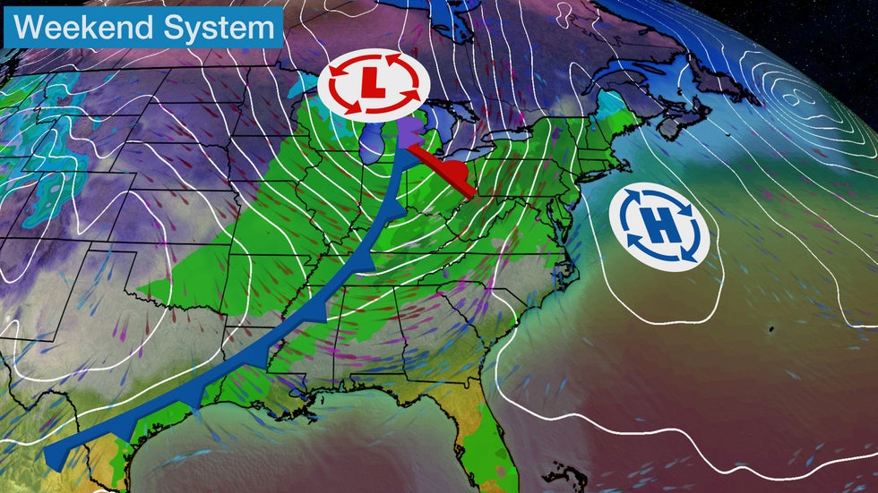 Low pressure system will track eastward this weekend.
Wet and Windy Forecast
Rain will develop from parts of the Southern Plains into the Midwest on Saturday.
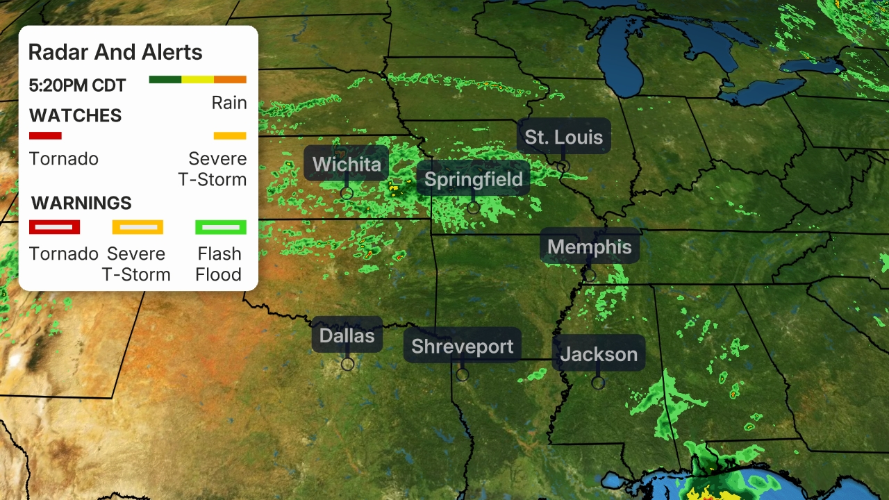
A few strong to severe thunderstorms, with gusty winds, hail or a tornado, are possible from eastern Oklahoma into much of Arkansas and southern Missouri during the afternoon into Saturday night.
Rain will spread as far east as the eastern Great Lakes and parts of the Tennessee Valley Saturday night.
Snow or a mix of rain and snow may also develop behind this low in northern Minnesota and portions of Wisconsin.
 Saturday's Forecast
Winds will increase Saturday into Sunday across the Plains into the Midwest and the Northeast, as this area of low pressure intensifies.
Wind gusts over 50 mph are possible in parts of the upper Midwest and Great Lakes region on Sunday.
Strong winds may also result in rising lake levels. Lakeshore flooding and erosion are concerns Sunday into Monday for the eastern shores of the Great Lakes.
 Wind Forecast
Wet weather will extend farther eastward on Sunday.
Rain is expected from the Northeast to southeastern Texas. However, much of the Southeast will stay dry as moisture will be more limited there. A few gusty thunderstorms are possible in southern New England late Sunday.
Some snow is also possible in parts of the western and northern Great Lakes, as well as the higher elevations of northern New England and portions of western and northern New York.
 Sunday's Forecast
Precipitation will move off the East Coast Sunday night so dry conditions likely Monday. However, some lake effect snow showers will develop early next week in the wake of this system, as a northwesterly flow will be in place.
Rainfall totals are expected to be on the light side with most locations receiving less than an inch.
Little snowfall accumulation is also anticipated. Generally less than 3 inches of snow will accumulate and the highest amounts will primarily be found in northeastern Minnesota, northern Michigan and northern Maine.
 Rain and Snow Forecast
The Weather Company’s primary journalistic mission is to report on breaking weather news, the environment and the importance of science to our lives. This story does not necessarily represent the position of our parent company, IBM.
The Weather Company’s primary journalistic mission is to report on breaking weather news, the environment and the importance of science to our lives. This story does not necessarily represent the position of our parent company, IBM.


No comments:
Post a Comment