weather.com meteorologists
Eta is expected to restrengthen to a tropical storm as it tracks across the northwestern Caribbean and could approach Cuba, the Bahamas and South Florida this weekend into early next week bringing flooding rain and high surf.
Eta has already unleashed deadly flooding and landslides as it passed over the mountainous terrain of Central America, particularly in Honduras. For more details on the flooding, check out our latest news article linked below.
(MORE: Eta Devastates Central America)
Eta's second wind is now about to begin, as its center is now back over the Caribbean Sea just east of Belize. Hurricane Hunter aircraft found sustained winds of 35 mph and a center that was further south than originally thought earlier in a flight Friday afternoon.
Strengthening of Eta is anticipated as it moves over the warm waters of the northwestern Caribbean Sea but some vertical wind shear may limit its intensification.
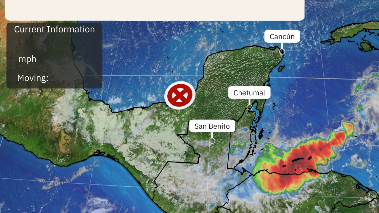 Current Information
Tropical storm warnings have been issued for the Cayman Islands and for much of central Cuba. Tropical storm conditions are possible there Saturday or Saturday night.
A tropical storm watch continues for western Cuba, including Havana, where tropical storm conditions are possible this weekend.
Additional watches will likely be issued later Friday for parts of the Bahamas, South Florida and the Florida Keys.
 Watches, Warnings
Eta will be steered northeastward over the northwest Caribbean by the interaction with the counterclockwise flow around an upper-level low-pressure system located in the Gulf of Mexico.
Eta is expected to interact or even combine with the upper low by this weekend. That could allow Eta to be pulled northward to just south of or even over the southern Florida Peninsula as a tropical or subtropical storm by early next week.
(MORE: What Is a Subtropical Storm?)
Eta could then be pulled westward into the eastern Gulf of Mexico by an upper-level high-pressure system over the eastern states.
Eta may meander for a few days before it is drawn northward by an upper-level trough later next week.
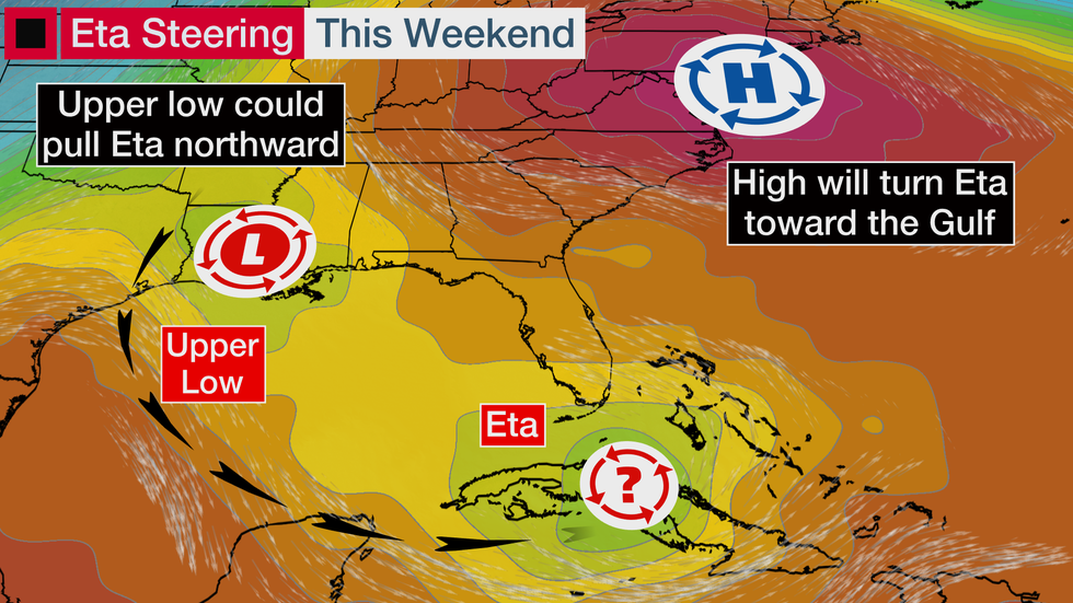
Assuming Eta does get pulled back over the eastern Gulf, instead of simply crawling north across the Florida Peninsula, it would then make a final landfall likely somewhere along either Florida's Gulf Coast or the northern Gulf Coast later next week, as it finally accelerates ahead of an approaching frontal system.
 Ensemble Model Forecast Tracks
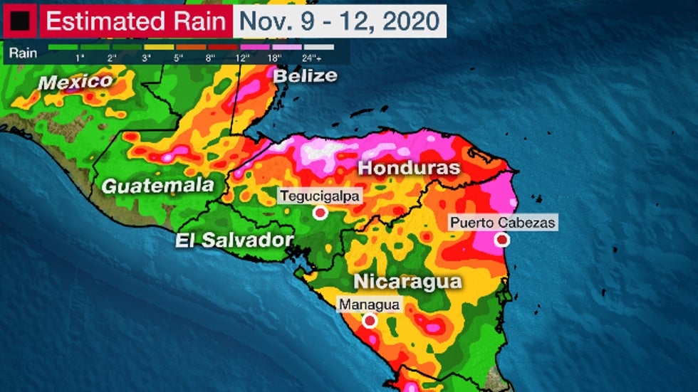
Heavy rain is also expected in parts of Cuba and the Cayman Islands, where the National Hurricane Center (NHC) says up to 30 inches could fall through early next week. Significant, life-threatening flash flooding and river flooding is possible there. In addition, a storm surge of 2 to 4 feet is likely to the east and north of where Eta tracks near Cuba.
No matter what eventually happens, parts of the Florida Peninsula are expected to see some bands of heavy rain associated with Eta's moisture as soon as this weekend that could lead to serious flash flooding. Rainfall is also possible ahead of Eta due to an increase in tropical moisture with a moist, easterly flow.
Southern Florida and the Bahamas are expected to receive 5 to 10 inches of rainfall through Wednesday morning, with isolated totals of 15 inches. A flood watch has been issued for much of the South Florida metropolitan area.
 Rainfall Forecast
Tropical storm conditions are most likely to arrive in the Florida Keys and coastal portions of South Florida late Sunday into early Monday.

Furthermore, the gradient between high pressure near the eastern U.S. and Eta's lower pressure will generate gusty winds blowing onshore along Florida's East Coast into next week.
That will allow high surf and dangerous rip currents to increase from Florida's East Coast to possibly as far north as South Carolina, peaking by early next week. Coastal flooding is likely in some of these areas, particularly at high tide.
High surf should also develop along Florida's West Coast and the northern Gulf Coast later next week while Eta is in the Gulf of Mexico.
The bottom line is that interests in the northwest Caribbean, Florida, and even parts of the U.S. Gulf Coast, should monitor the progress of Eta and its forecast.
Check back to weather.com for updates as the forecast becomes more clear over the next few days.
Central America Rainfall Flood Catastrophe
Nicaragua and Honduras have seen roofs ripped off of homes, trees uprooted, bridges washed out, landslides and flooded roads.
As feared, torrential rain from Eta triggered massive flooding in parts of Central America.
One of the hardest-hit areas was western Honduras.
Flooding inundated Ramón Villeda Morales International Airport near San Pedro Sula, Honduras.
Water was up to the rooftops in parts of San Pedro Sula, Thursday. Video showed hundreds of people on rooftops and the second story of buildings waiting for rescue.
Water levels along the Ulúa River in western Honduras were said to have been 13 feet higher than the peak during Hurricane Mitch in 1998. Catastrophic flooding was also expected along the Choluteca River in the town of Marcovia, in southern Honduras, south of the capital Tegucigalpa.
(MORE: Eta Triggers Memories of Mitch 22 Years Ago)
Over 22 inches of rain was recorded in Tela on the Caribbean coast since Monday.
Some locations picked up over 10 inches of rain in one day, including Puerto Barrios, Guatemala (13.98 inches).
The NHC was forecasting storm totals could reach 40 inches in parts of Honduras and Nicaragua.
Eta's Storm History
Eta is the 28th storm of the 2020 Atlantic hurricane season, which ties the 2005 season for the most storms on record. It's also the 12th hurricane of the season, which ties for the second-most on record for a year in the Atlantic.

Maximum sustained winds in Eta increased from 70 mph to 150 mph in just 18 hours ending 7 p.m. EST Monday. That's more than double the criteria for the rapid intensification of a tropical cyclone, which is a wind speed increase of 35 mph or more in 24 hours or less.
At its peak late Monday and early Tuesday, Eta was the third-strongest November hurricane on record in the Atlantic by wind speed and just the fifth Atlantic Category 4 or higher hurricane to occur in the month. Paloma in 2008 was the last November Category 4 hurricane in the Atlantic.
Eta was the ninth storm of the 2020 Atlantic hurricane season to undergo rapid intensification.
Eta's central pressure plunged 82 millibars in 48 hours ending 1 a.m. ET Nov. 3, one of the largest 48-hour pressure drops on record in the Atlantic Basin, according to Sam Lillo, a NOAA researcher based in Boulder. Only hurricanes Andrew, Rita and Wilma had as large or larger pressure drops in a 48-hour period than Eta, Lillo found.
The small hurricane produced prolific lightning flashes in its eyewall Monday afternoon, one sign of its intensity.
Eta's eye arrived along the coast of Nicaragua about 15 miles south-southwest of Puerto Cabezas, Nicaragua around 4 p.m. EST Tuesday. At that time, maximum sustained winds were estimated at 140 mph, a Category 4 hurricane on the Saffir-Simpson hurricane wind scale, according to the NHC.
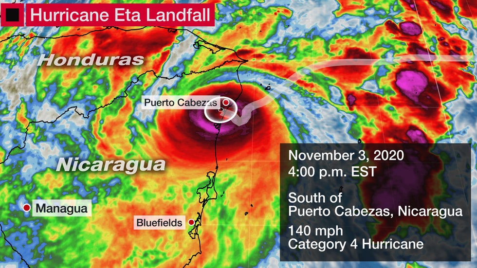
Eta was only the fifth Category 4 or stronger hurricane on record to landfall in Nicaragua, the first since Category 5 Hurricane Felix in 2007.
Winds had gusted up to 136 mph near Puerto Cabezas, Nicaragua, Tuesday afternoon.
The NHC forecasted a destructive storm surge inundation of 14 to 21 feet above normal tide levels near where Eta made landfall. This is roughly the magnitude of storm surge experienced during Category 5 Hurricane Felix in 2007.
The Weather Company’s primary journalistic mission is to report on breaking weather news, the environment and the importance of science to our lives. This story does not necessarily represent the position of our parent company, IBM.
The Weather Company’s primary journalistic mission is to report on breaking weather news, the environment and the importance of science to our lives. This story does not necessarily represent the position of our parent company, IBM.


No comments:
Post a Comment