Jonathan Erdman
A worsening New England drought may finally experience its first soaking rain in a month or more in the week ahead.
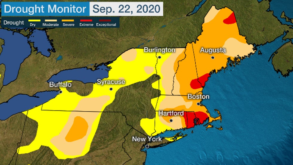
As of the September 22, Drought Monitor analysis from the U.S. Drought Mitigation Center showed that virtually all of New England was in drought, with parts of Maine, New Hampshire, southern Massachusetts, Rhode Island and Connecticut in "extreme" drought, the second highest category in the analysis.
It's the first time Rhode Island has been in this second highest "extreme" drought category since the Drought Monitor analysis was launched in 2000.
Parts of central and upstate New York, as well as central Pennsylvania, were also in drought.
 The
U.S. Drought Monitor analysis as of Sep. 22, 2020 shows virtually all
of New England in drought of varying severity. Extreme drought, the
second highest category of drought, was in place over parts of Maine,
southern New Hampshire, southern Massachusetts, Rhode Island and
Connecticut. Areas not yet in drought but rather abnormally dry are
shown in yellow.
The
U.S. Drought Monitor analysis as of Sep. 22, 2020 shows virtually all
of New England in drought of varying severity. Extreme drought, the
second highest category of drought, was in place over parts of Maine,
southern New Hampshire, southern Massachusetts, Rhode Island and
Connecticut. Areas not yet in drought but rather abnormally dry are
shown in yellow.This drought first developed in June and then shifted into another gear from late August through September.
It spread and worsened so quickly in parts of New England that it met the criteria to be considered a flash drought, instead of a more typical, slowly-developing drought.
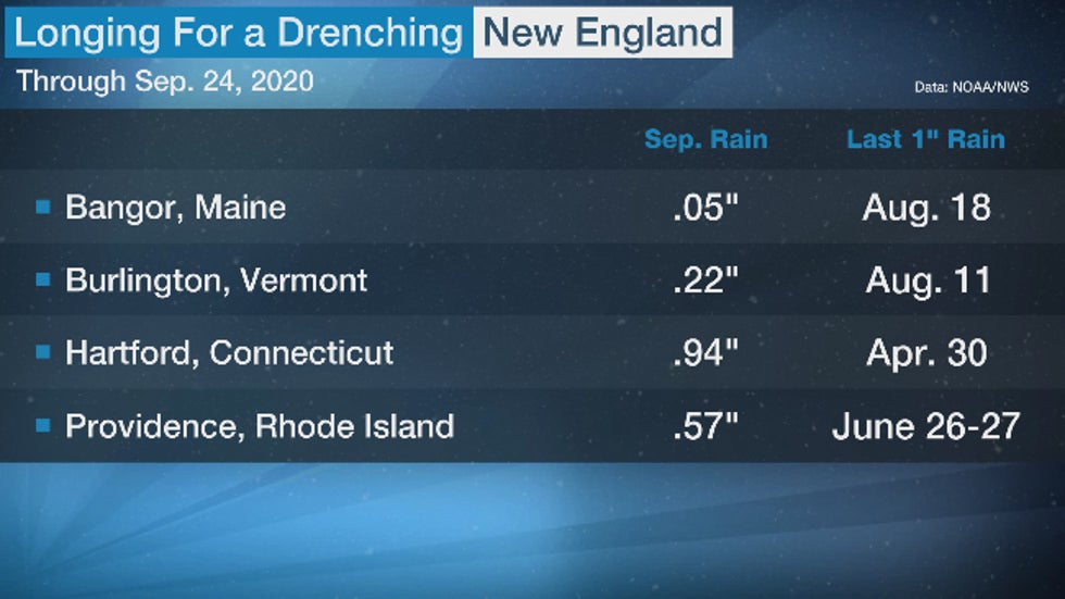
Through September 24, it's been the driest September-to-date in a number of cities, including Augusta, Maine; Burlington, Vermont; and Montpelier, Vermont, according to the Southeast Regional Climate Center.
Most New England cities haven't picked up an inch of rain in at least a month.
Residents of Hartford, Connecticut, haven't seen a one-inch-plus rain event since April 30. Manchester, New Hampshire, has a precipitation deficit since mid-May of over 10 inches.

Flash droughts typically offer less time to prepare for impacts such as crop losses, reductions in water supply and increased wildfire risk.
For example, in Maine, the USDA declared Aroostook County a drought disaster, making low-interest federal emergency loans available to those affected.
Forty percent of U.S. Geological Survey streamflow gauges in Maine with at least 30 years of data are at record low levels for this time of year, Nick Stasulis of the New England Water Science Center told the Portland Press Herald.
Over a dozen small wildfires were burning in the state Wednesday, and 1,000 wildfires had been documented so far this year.
Residents in Massachusetts, Connecticut and Rhode Island were asked to conserve water, particularly through reductions in outdoor watering, and told to avoid outdoor burning.
About 100 wildfires have burned in Rhode Island so far in 2020, but have only damaged a couple of buildings, the Boston Globe reported.
Relief Ahead
Fortunately, there is relief ahead.
A pattern change that is ushering in colder air to much of the central and southern U.S. in the week ahead will drive a frontal system toward the East Coast.
Warm, moist air ahead of that front will wring out at least some rain over New England.
The longevity and total amount of rain are challenging to predict.
Some computer forecast models suggest the front will push off the East Coast sooner, while others suggest the front will stall for a time, allowing a second wave of soaking rain later in the week.
(MAPS: 7-Day Rain Forecast)
 Rainfall Outlook
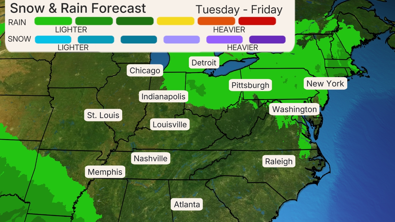
Most of the computer model guidance suggests a majority of New England has a good chance of picking up at least an inch of total rainfall in the week ahead.
So, while it's not completely clear yet this will be a heavy rain event, multiple days of rain should help at least dampen dried out vegetation, reduce the threat of wildfires and replenish rivers.
The Weather Company’s primary journalistic mission is to report on breaking weather news, the environment and the importance of science to our lives. This story does not necessarily represent the position of our parent company, IBM.
The Weather Company’s primary journalistic mission is to report on breaking weather news, the environment and the importance of science to our lives. This story does not necessarily represent the position of our parent company, IBM.

No comments:
Post a Comment