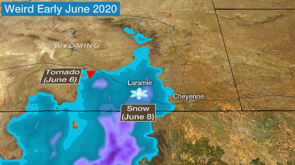
 The location of the EF1 tornado in the Snowy Range on June 6, 2020, and contours of snowfall which occurred two days later in southeast Wyoming, including Laramie.
A recent bizarre stretch of weather in southeast Wyoming began with a damaging mountain tornado last Saturday, then one of their heaviest June snowstorms on record two days later.
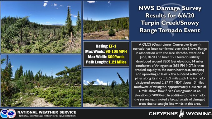
The National Weather Service office in Cheyenne, Wyoming, confirmed an EF1 tornado touched down last Saturday, June 6, in the Snowy Mountain Range, about 95 miles west-northwest of the state capital, Cheyenne.
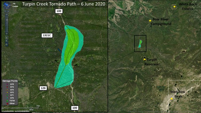
A tornado has been confirmed in the Snowy Range during last Saturday's (6 June 2020) severe weather.
For additional information, check out the latest Public Information Statement on the damage survey results: bit.ly/2zwa0gk
According to the NWS damage survey, the brief tornado snapped and uprooted "at least a few hundred" trees, blocking roads near Turpin Reservoir. Based on the damage, the NWS estimated winds in the tornado ranged between 90 and 105 mph.
Strong rotation detected by Doppler radar prompted the NWS to issue a tornado warning on that storm.
This EF1 tornado was a part of a rare Western U.S. derecho, a large-scale, thunderstorm-generated damaging windstorm which swept from Utah across Wyoming and Colorado into the Dakotas and western Nebraska on June 6.
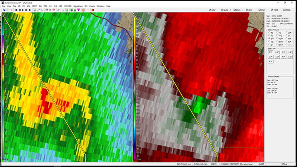 Radar reflectivity (left) and storm-relative velocity (right) of the Snowy Range tornado on June 6, 2020.
This Snowy Range tornado damage occurred at elevations up to 9,200 feet.
It turns out tornadoes have been documented at even higher elevations.
The highest-elevation tornado on record in the U.S. was documented by a hiker on July 7, 2004, in Sequoia National Park, California, at an elevation of about 12,156 feet, according to a 2014 study on the event.
And, as Kathryn Prociv pointed out in a 2013 column on ustornadoes.com, though mountain tornadoes aren't nearly as numerous as those elsewhere in the nation, they're certainly not rare.
Then, a June Snowstorm
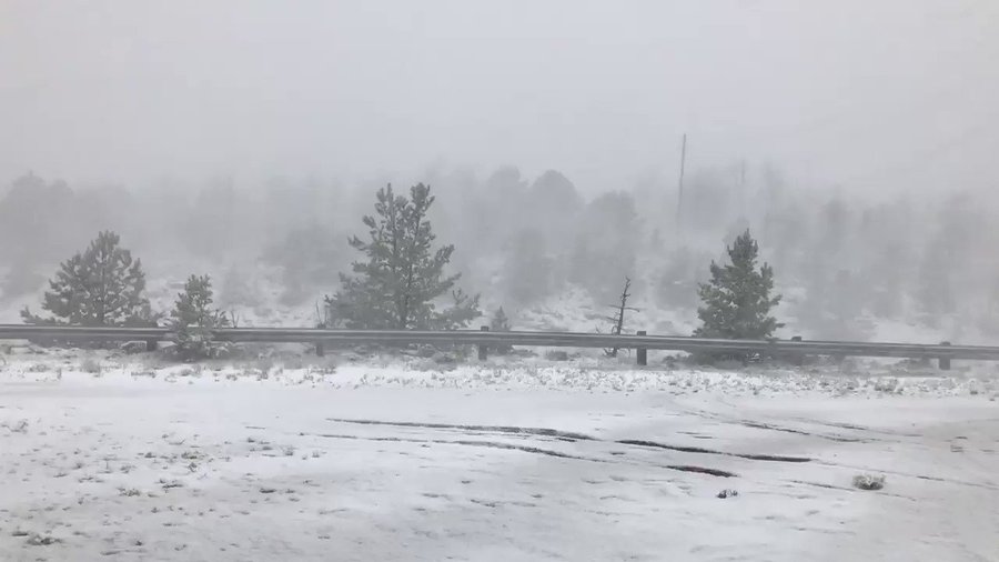
Just two days after the tornado and derecho roared through, a strange early June snowstorm blanketed southeast Wyoming, including the Snowy Range on Monday, June 8.
Up to 8 inches of snow was reported in Laramie, accompanied by numerous claps of thunder and lightning flashes. The wet, heavy late spring snow downed trees and knocked out power in the city of about 32,000 residents.
Just had a significant tree break land on our house. We're all good, just shaken up. #wywx
The snow prompted a shutdown of Interstate 80 between Laramie and Cheyenne, one of the nation's most frequently-closed stretches of interstate due to weather, from June 8 into the morning of June 9.
This may have been one of the heaviest June snowstorms on record in southeast Wyoming.
While snowfall data at Laramie Regional Airport hasn't been continuously taken since 2000, the snowiest June day on record in Laramie was a 6-inch event on June 8, 1974. Laramie only averages about 0.2 inch of snow each June, sometimes occurring as hail, which is recorded as snow in official records.
This storm prompted the first June winter storm warning in southeast Wyoming since at least 2005, according to Jared Allen, warning coordination meteorologist at NWS-Cheyenne.
Perhaps strangest of all, this was Laramie's heaviest snowstorm of the "winter" season, according to University of Wyoming atmospheric scientist Phil Bergmaier.
93° and tornadoes yesterday in the Dakotas, 35° and absolutely dumping today in Wyoming #wywx
That's worth repeating. The heaviest snowfall of the entire 2019-20 season from fall through spring in Laramie, Wyoming, happened in ... June.
It's no wonder the signs you see crossing the state line into Wyoming say, "Like no place on Earth."
The Weather Company’s primary journalistic mission is to report on breaking weather news, the environment and the importance of science to our lives. This story does not necessarily represent the position of our parent company, IBM.
The Weather Company’s primary journalistic mission is to report on breaking weather news, the environment and the importance of science to our lives. This story does not necessarily represent the position of our parent company, IBM.




No comments:
Post a Comment