A strange temperature pattern will be in place in the East the next several days, in which one location in northern Maine has tied its all-time heat record while areas farther south are nowhere near as hot.
It’s mid-June, and typically, the heat would be on in the Carolinas, while way up north, Maine would be dealing with black flies and still shrugging off the chill of spring.
Not this year, though.
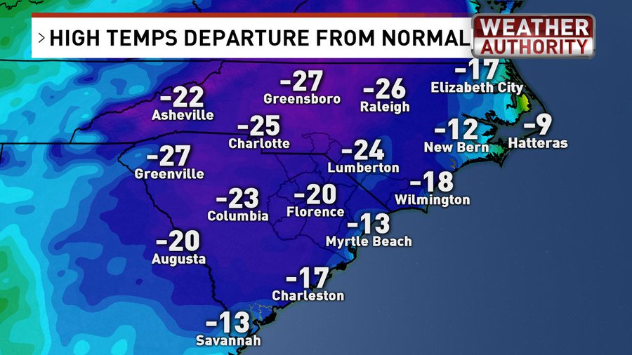
While parts of North Carolina saw record-cold high temperatures earlier this week, parts of northern New England will see multiple days with highs in the 90s into the weekend.
Caribou, Maine – one of the farthest-north towns in the continental U.S. – was one of the hottest place east of the Mississippi River on Friday.
(MAP: Current U.S. Temperatures)
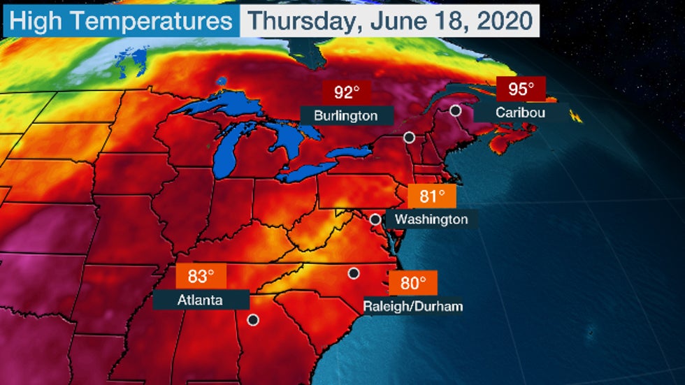
 Actual high temperatures in the eastern U.S. on Thursday, June 18, 2020.
Caribou reached 96 degrees Friday afternoon for the first time since 1977, tying its all-time record high.
The previous all-time record high was set both on May 22, 1977, and June 29, 1944. Weather records, there, date to 1939, though, the NWS noted other northern Maine locations soared to 100 degrees in heat waves prior to 1939.
Caribou reached 95 degrees on Thursday, and a number of other locations in Maine hit the mid-90s.
According to the National Weather Service, Thursday was their hottest day in almost 29 years, since they reached 95 degrees on July 20, 1991.
This 90-degree heat could last into the weekend in Caribou.
This might not sound all that noteworthy if you live in Florida, Texas or Arizona. But in northern Maine, this is a potentially record-tying stretch of heat.
Caribou's record stretch of 90-degree-plus highs was four, set three other times in 2010, 1963 and 1949. This stretch could tie that record.
They average just two to three days of 90-degree-plus heat each year. Caribou's average high this time of year is only 72 degrees.
Compare that heat to the rather muted high temperatures in the typically hotter mid-Atlantic states, even the Deep South.
The heat was even more impressive in eastern Canada.
Sept-Îles, Quebec, typically protected from heat by its coastal locations along the mouth of the St. Lawrence River, crushed its all-time record high by over 4 degrees Celsius Thursday, topping out at 36.6 degrees Celsius (97.9 degrees Fahrenheit).
36,6 degrés! C'est le record de température absolu enregistré hier à Sept-Îles provoqué par un puissant vent NO qui a repoussé la brise de mer qui permet habituellement à la ville de conserver des températures fraîches. Le passage d'un front aujourd'hui rétablira la situation.#mm
Two other Canadian cities set new June heat records Thursday.
Bathurst, New Brunswick, chalked up the hottest temperature in eastern Canada, Thursday, soaring to 37.2 degrees Celsius (99 degrees Fahrenheit).
Fredericton, New Brunswick toppled a record high for the month of June on Friday.
=NEW RECORD=
It appears #Fredericton, NB has set a new all time high record for the month of June.
Max temperature over the past hour was 36.1°.
That breaks the old record of 35.6° set back in June of 1944.
cc: @Pat_wx #nbwx #nbstorm
'Rex Block' Pattern Leads to Upside-Down Temperatures
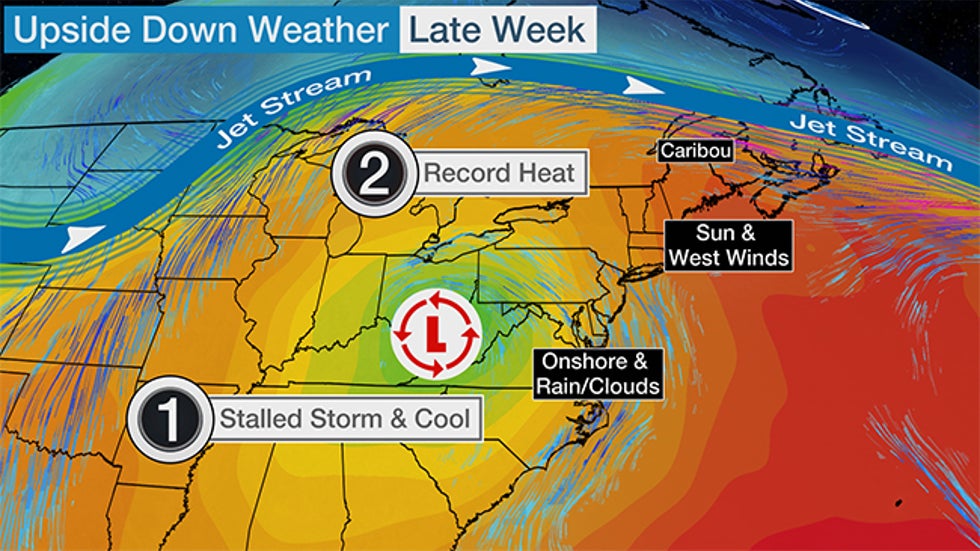
The weather pattern responsible for both the heat in Maine and the cold, clammy weather in the Carolinas is known to meteorologists as a “Rex block,” where a ridge of high pressure is located to the north of a low-pressure system.
Where you are located in this pattern means everything as far as the type of weather you get.

The heat in Caribou is attributable to that ridge of high pressure that has set up across New England. High-pressure systems are synonymous with great weather featuring sunny skies and warm temperatures.
For Mainers, the result will be beautiful sunny skies and exceptionally hot temperatures. Since the prevailing winds will not be coming from the cold ocean, where water temperatures are hovering from the mid-40s to upper 50s, even coastal areas will soar well into the 80s before a sea breeze tempers the heat.
On the flip side, parts of the Carolinas saw consecutive days of record-cool high temperatures earlier this week. Florence, North Carolina, stayed below 70 degrees for 43 hours. Only 1967 and 1997 saw longer June streaks there.
(MORE: Another Slow Low Soaked the East)
Earlier in the week, the weather pattern across the Carolinas and much of the mid-Atlantic into the Southeast was dominated by a bowling-ball-type cold-core closed low, as shown in the setup map above. These closed lows are notorious for bringing cold, rainy weather during the warmer months and prolonged cold and snow in the winter.
A flow off the Atlantic brought more moisture to the Carolinas, which resulted in very heavy rainfall, hail and even a report of a tornado. Significant flooding occurred, with over 8 inches of rainfall reported in parts of North Carolina.
As they often say in real estate, it’s location, location, location.
Where you sit in the large-scale weather pattern often dictates the type of normal or abnormal weather you experience.
This week’s Rex block in the East will result in winners and losers in the weather world, and depending on your location, you may be thanking or cursing those weather gods.
The Weather Company’s primary journalistic mission is to report on breaking weather news, the environment and the importance of science to our lives. This story does not necessarily represent the position of our parent company, IBM.
The Weather Company’s primary journalistic mission is to report on breaking weather news, the environment and the importance of science to our lives. This story does not necessarily represent the position of our parent company, IBM.


No comments:
Post a Comment