A wetter pattern is bringing thunderstorms with soaking rain to parts of the Central and Southern Plains, but some of these thunderstorms will likely turn severe on Father's Day following calmer times in Tornado Alley.
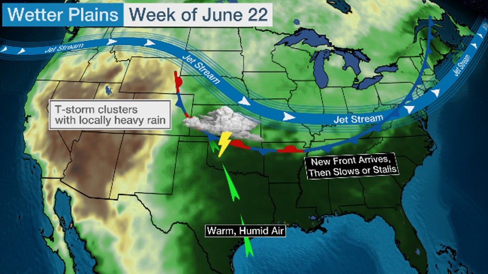
A Wetter Pattern Change
Fortunately, the stubbornly dry, hot pattern from earlier this month has finally relented as high pressure that dominated the Plains earlier this month has given way.
Instead, the jet stream will gradually carve out a southern plunge over the Midwest this week, sending a number of disturbances out of the Rockies and into the Plains.
That will send a couple of frontal system south and east through the Plains, each eventually stalling out.
Southerly winds will head north from the Gulf of Mexico, supplying humid air ahead of each frontal boundary.
This will all result in a wetter pattern into the upcoming week.
Severe Weather Forecast
On Father's Day, severe thunderstorms will develop across the Plains with damaging thunderstorm winds, large hail and possibly a few tornadoes, particularly in the areas shaded in darkest red on the map below.
 Sunday's Severe Thunderstorm Forecast
Additional at least scattered severe thunderstorms are possible once again Monday in the Plains, particularly in parts of Oklahoma.
These strong storms won't simply occur during daylight hours. Typical of the Plains states in summer, these daylight scattered thunderstorms are expected to merge and congeal into larger thunderstorm clusters at night, with the potential of strong winds and locally heavy rain.
Rain Too Much of a Good Thing?
By Tuesday or Wednesday, the first frontal system should sag as far south as parts of the Southern Plains, giving some parts of the Central Plains a break from the recent, daily siege of storms.
Late in the week, a second frontal system will slide into the Northern and Central Plains, bringing another chance of thunderstorms with soaking rain.
Parts of the Plains, particularly in Oklahoma and Texas along and east of Interstate 35, have a good chance of picking up at least an inch of rain this week.
Where slow-moving thunderstorms or clusters of storms stall briefly, flash flooding is possible.
Areas farther to the west in the area of the current flash drought, however, have less of a chance of soaking rain this week.
 Rainfall Outlook
Dry, Stormless Stretch Resulted in Drought Growth
Until Friday, an expansive area of the High Plains from western Kansas to western Oklahoma, eastern New Mexico and western Texas had turned much drier since April and plunged into drought, according to the latest U.S. Drought Monitor analysis.
Parts of the Central Plains have even gone without any tornado watches through the first half of the year.
Much of Kansas and western Oklahoma have not had any tornado watches even in June.
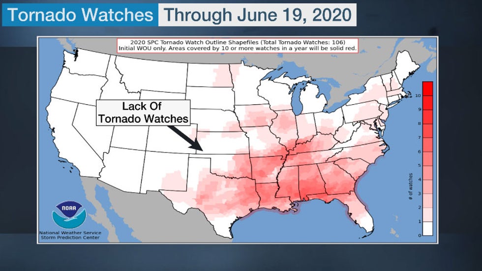 Tornado watches issued by NOAA's Storm Prediction Center in 2020 through June 19. Greater number of watches show up as darker red contours.
Following an active April in the Southeast, May and June have been rather calm in the usually busy Plains states for tornadoes. This has led to a drop in the number of tornado reports relative to average.
Through June 19, the United States has seen nearly 800 reports of tornadoes while the average is 930 reports of tornadoes year to date.
Overall severe weather has largely avoided the Southern Plains this June.
The map below from the Storm Prediction Center (SPC) shows where wind (blue), hail (green) and tornadoes (red) were reported in the first 19 days of June. Note the relative lack of reports from Kansas to eastern Oklahoma and much of Texas, despite the larger number of dots just north of the region.
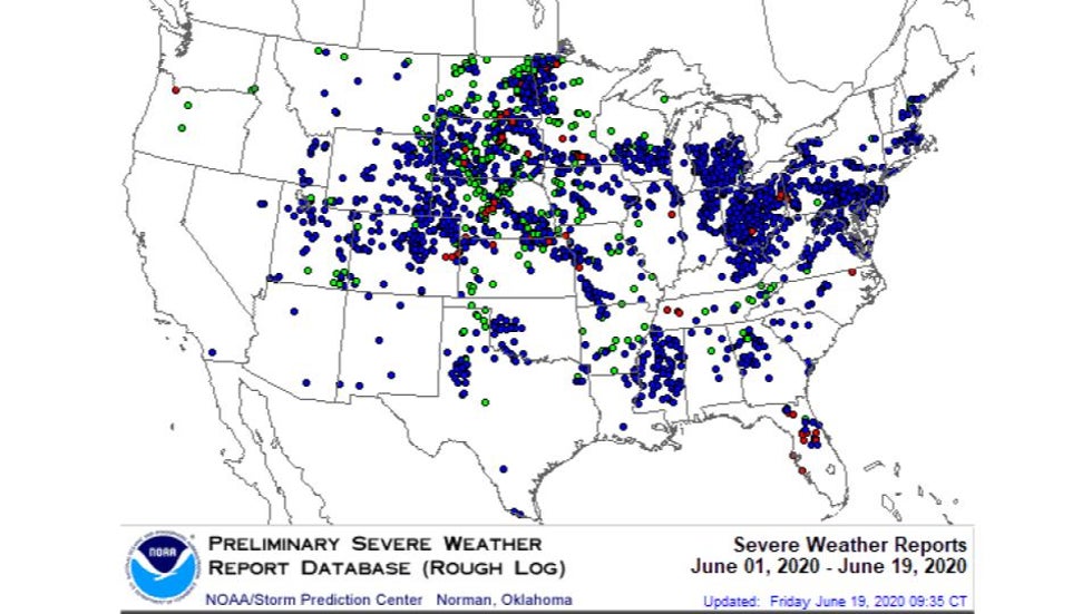 June Severe Weather Reports
The reason for a relatively calm severe weather spring from Kansas to Texas has been the northerly storm track that has directed storm systems, including multiple derechos, through the Northern Rockies, Northern Plains and the Great Lakes.
With a lack of storm systems in the Southern Plains, many cities have also been asking for even a little rain.
Dallas, Oklahoma City and Tulsa, Oklahoma, were among the Southern Plains cities that hadn't reported any measurable rain this month through June 18.
But there was good news on that front.
Friday, a pair of thunderstorm clusters merged over Oklahoma, bringing a much-needed soaking to parts of the Sooner State, as well as much of Kansas and the northeast Texas panhandle.
Oklahoma City broke its dry streak on Friday in spectacular fashion with just over two inches of rain.
The first rainfall in June also fell in parts of northern Texas from Friday into early Saturday. Dallas Love Field Airport picked up almost 4.5 inches during this period and there were reports of roadway flooding early Saturday. Wichita Falls measured just under an inch and Waco reported just over an inch as of early Saturday.
The Weather Company’s primary journalistic mission is to report on breaking weather news, the environment and the importance of science to our lives. This story does not necessarily represent the position of our parent company, IBM.
The Weather Company’s primary journalistic mission is to report on breaking weather news, the environment and the importance of science to our lives. This story does not necessarily represent the position of our parent company, IBM.


No comments:
Post a Comment