Most people associate June with summertime – sunshine and warm temperatures. And for much of the country, this is typically the weather that occurs in summer's first month.
But that isn't the case for parts of the California coast – and if you're planning to visit early in the summer, don't forget a jacket.
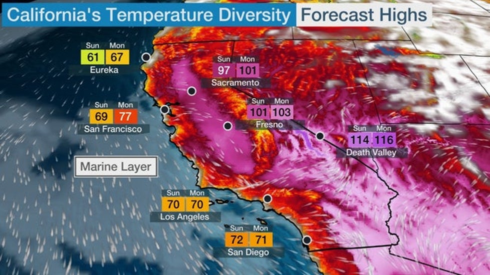
Often, the coast will be at least 30 degrees cooler than parts of the Central Valley, and even cooler in comparison to the deserts of southeastern California.
From Eureka, entrenched in the "June Gloom," to Death Valley, located in the clearer air of the desolate valleys, a 50-degree difference in temperature is often the case. A spot or two along the immediate coast of Northern California could stay in the upper 50s or low 60s with onshore winds off the chilly Pacific Ocean, while Death Valley will roast in temperatures exceeding 110 degrees.
 A sample of forecast highs and areas of clouds illustrating the contrast between the chilly, cloud-shrouded California coast and the blazing hot interior of California and the Desert Southwest in June.
The culprit along the Golden State's coast is a bank of low clouds and fog that develops during the morning hours, and usually mixes out and erodes during the midday or early in the afternoon.
Therefore, it's best to sleep in and wait until the afternoon to head to Southern California's beaches, especially in early summer.
The fog is so common during June that it even has a mascot in San Francisco – meet Karl the Fog.
Why Is It So Foggy in Summer?
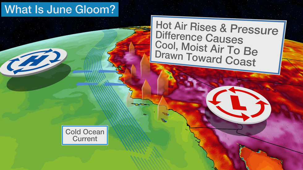
The source of the fog is from the marine layer – a shallow layer of clouds that forms over cold air. The cold air comes from the chilly ocean current, which brings cold air from the Gulf of Alaska southward along the West Coast.
 Setup for June Gloom
Typically, this cold air remains off the coast, but as we enter the summer season, intense heating of inland areas, such as the Central Valley and Mojave Desert, sets up a broad area of low pressure known as a thermal low.
With relatively higher pressure over the Pacific Ocean, a pressure gradient develops and pushes the cooler and more humid ocean air inland. If this marine layer is deep and moist enough, low clouds and fog are the result.
(MORE: The 15 Most Frustrating Weather Patterns)
 In this file photo, beachgoers in Santa Monica, California, don't let low clouds and fog ruin their day.
"It's worth pointing out that most locations away from the coast, especially more than 10 miles or so inland, do not see nearly the impact as locations along the immediate coast," said the National Weather Service in San Diego in a Facebook post. "Conversely, the SoCal beaches will see even less sunshine, on average, than the airport location."
The NWS added that May features only 59 percent of possible sunshine and only 58 percent of possible sunshine occurs in June, based on averages at San Diego International Airport.
The marine layer doesn't make much inland progress because inland air is warmer and mixes as it heats up during the day.
Even the higher terrain along the coast can be significantly warmer than elevations a few thousand feet lower and closer to the coast. This is because the summertime sun still brings significant heating to much of the atmosphere, but cannot mix down to the chilly Pacific Ocean.
This creates an inversion, or an upside-down temperature pattern, in the lower layers of the atmosphere.
Usually, temperatures decrease as you go up higher in the atmosphere, but with the cold Pacific air near the ground and the warm summer sun trying to reach the ground, temperatures increase with height along the California coast. This means mountain peaks can be 20 to 30 degrees warmer than the coast just a few miles away.
 This NASA Worldview visible satellite image shows low clouds and fog along the coast of Southern California on May 30, 2017.
Farther north, in the San Francisco Bay Area, low clouds and fog are also common in the morning, but strong winds through the Golden Gate Bridge typically mix out the marine layer by the afternoon.
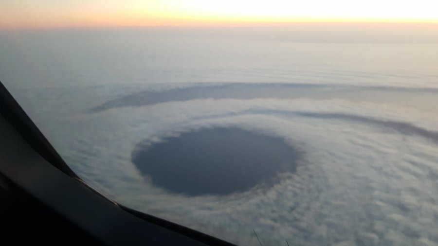
A common sight along the California coast in spring and summer is a coastal eddy, in which the low stratus cloud deck takes on the shape of a hurricane.
@MFollowill hey weather guesser! Saw this flying over monterrey bay ca. Low coastal fog but a dramatic hole. Looks like a hurricane?!
"We see them on a regular basis," Jan Null, a Bay Area-based certified consulting meteorologist and former lead forecaster at the NWS in Monterey, California, told weather.com. "During the summer, we'll see at least one a week if there's a stratus field."
(MORE: No, This Isn't a Hurricane Off the California Coast)
April through September is when these types of eddies are very common along the coast of California, the NWS-Monterey said.
The Weather Company’s primary journalistic mission is to report on breaking weather news, the environment and the importance of science to our lives. This story does not necessarily represent the position of our parent company, IBM.
The Weather Company’s primary journalistic mission is to report on breaking weather news, the environment and the importance of science to our lives. This story does not necessarily represent the position of our parent company, IBM.


No comments:
Post a Comment