May brings several notable changes in the nation's weather compared to earlier in the spring.
Severe thunderstorms are often one of the first weather concerns that come to mind in May, but another area to watch is the tropics as hurricane season approaches. For many, though, warmer temperatures are one of the highlights as summer inches closer.
Severe Weather Ramps Up
In most years, May is when the peak of tornado activity occurs in the United States. This is the time of year ingredients for severe thunderstorms come together most often.
The setup for severe thunderstorms typically includes disturbances in the jet stream pushing out of the Rockies and into the Plains, interacting with warm air and ample moisture.
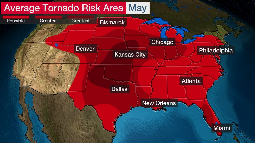
 Average tornado risk area for May.
In May, the area where these ingredients have the highest chance of coming together is from Texas to Iowa.
Violent tornadoes are more likely at this time of year, and numerous tornado and severe weather outbreaks have occurred in May.
Based on data from 1999 to 2018, the average number of tornadoes in the U.S. in May is 272, notably higher than the second-highest month for tornado activity, June, which averages 202 tornadoes.
(MORE: The U.S. Is Having One of Its Deadliest Tornado Years in a Decade)
Tropical Activity Begins to Wake Up
The Eastern Pacific hurricane season officially begins May 15, a little earlier than the Atlantic season because sea-surface temperatures are typically warmer and wind shear is usually weaker in the Eastern Pacific compared to the Atlantic earlier in the season.
Last weekend, Tropical Depression One-E became the earliest tropical cyclone on record to form in the Eastern Pacific Basin when it developed April 25. It was short-lived and did not affect any land areas.
Tropical cyclones that form in the Eastern Pacific can impact Mexico and Central America, and moisture from these systems can reach the southwestern U.S.
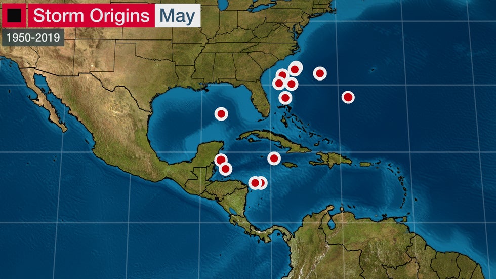
Tropical cyclones also occasionally form in the Atlantic prior to the official start of hurricane season, June 1. In May, areas from the western Caribbean to the southeastern U.S. coast and into the Gulf of Mexico are favored for development, as Colorado State University tropical scientist Phil Klotzbach pointed out.
 Each point on the map represents a tropical cyclone that formed in the Atlantic Basin in May between 1950 and 2019.
From 1851-2019, 38 named storms formed in the Atlantic Basin before June 1, a long-term average of one such early storm every four to five years.
Since 2015, at least one named storm has developed before June 1 each hurricane season, some of which had impacts in the United States and elsewhere in the Atlantic Basin.
(MORE: Atlantic Hurricane Season Has Started Early 5 Straight Years)
Wet Season Starts in Florida
In Florida, the wet season – the time of year when most of the annual precipitation occurs – begins in May and lasts through October.
Miami receives about 47 inches of rainfall, or almost 75% of its average annual rain, from May to October.
Cold fronts no longer push as far south into Florida, which allows for warmer temperatures and increasing humidity across the state.
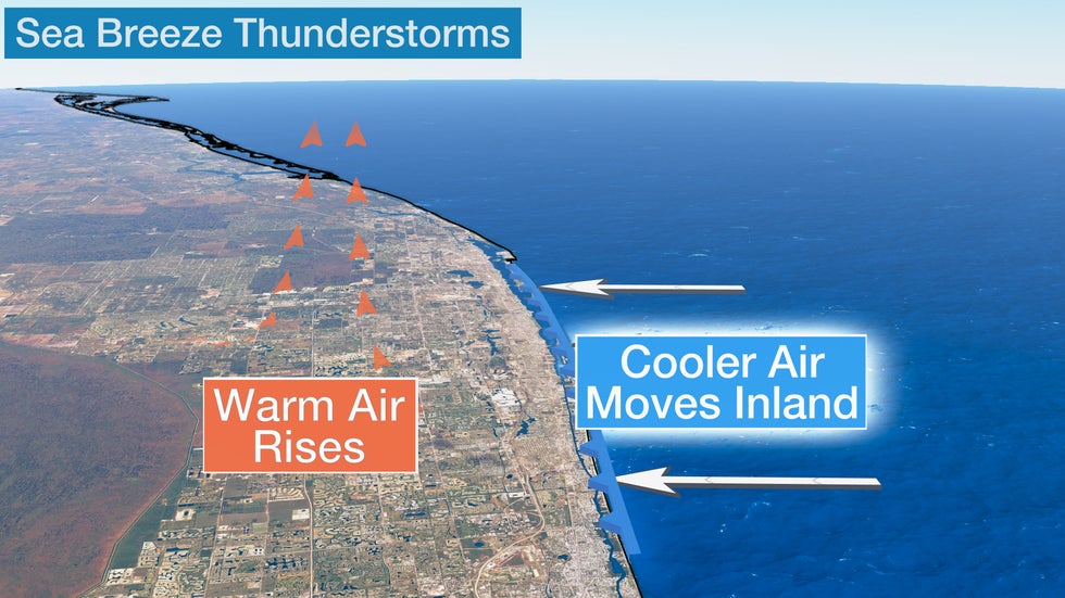
Thunderstorm activity increases, bringing the increase in rainfall. Thunderstorms develop along sea-breeze fronts, as cooler air slides inland from the Gulf of Mexico and the Atlantic Ocean.
 Cooler air slides inland from the Gulf of Mexico and the Atlantic Ocean to replace warm air that is rising into the atmosphere.
Hurricane season also brings an increased chance for rainfall. It doesn't take a strong hurricane to bring heavy rainfall to the Sunshine State. Slow-moving tropical storms or tropical depressions can result in excessive rainfall in the region.
(MORE: 13 Things You Might Not Know About Thunderstorms)
Feels More Like Summer by Month's End
Average high and low temperatures are fairly mild for the most part across the U.S. in early May. However, by the end of the month, average temperatures begin to erase thoughts of winter in most locations.
The Northeast and Midwest regions both typically have signs of summer by Memorial Day.
The average high in New York City reaches 75 degrees and the average low is 59 degrees by May 31, a big improvement from the average low of 40 degrees in early April. Chicago experiences a 10-degree temperature increase in its average high temperature from May 1 to May 31, rising from 65 degrees to 75 degrees, and the average low climbs from 44 degrees to 53 degrees.
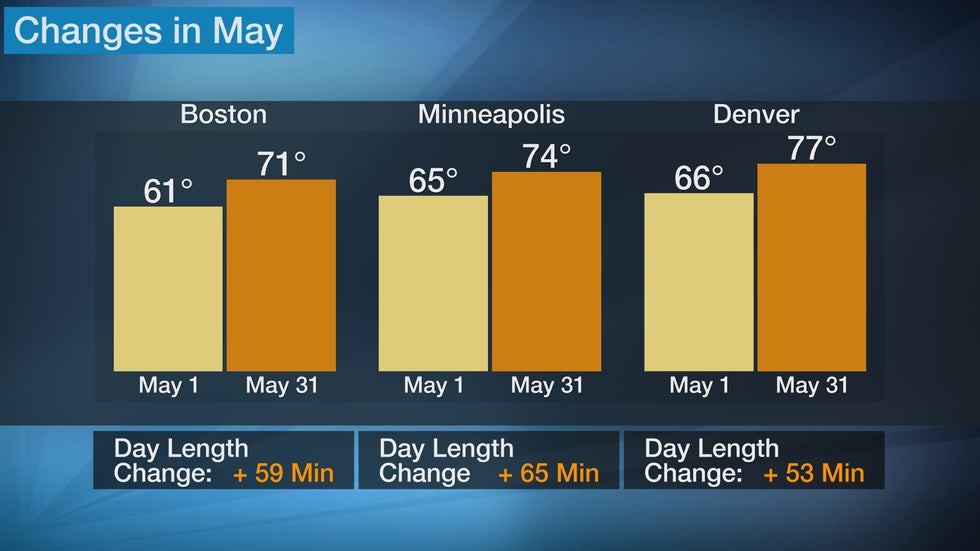
 This graph shows changes in high temperature and daylight length from May 1 to May 31.
Farther west, Denver has an average high in the mid-60s in early May but reaches 77 degrees by May 31. Average low temperatures also increase by about 10 degrees, reaching the upper 40s by late May.
Areas across the South see the heat continue to build. Dallas has an average high of 80 degrees on May 1, but it climbs to 88 degrees by May 31, when the average low is 68 degrees. The average high in Atlanta reaches the mid-80s by May 31, and the average low is in the mid-60s.
One of the biggest signs of summer is the increase in daylight hours. This is especially evident across the northern tier of the U.S.
Boston and New York City have an increase in daylight hours of almost an hour from the start of the month to the end. Minneapolis experiences an increase of 65 minutes during this time, while Seattle has an increase of 72 minutes. Farther south, areas from Atlanta to Los Angeles have an increase in daylight of more than 40 minutes.
Snow Becomes Less Likely
Of course, along with the warmer conditions comes a much-reduced chance of snow.
Although snowfall becomes rarer as May progresses, snow can still fall. Areas that typically experience snowfall in May are in the higher elevations in the western U.S. and Alaska.
 This map shows how much snow typically falls between April 1 and June 30 in the United States, based on NOAA/NCEI climatological averages from 1981 to 2017.
The latest named winter storm occurred on May 18-19, 2017, when Winter Storm Valerie brought more than 40 inches of snow to parts of the Rockies. Cheyenne, Wyoming, recorded 11 inches of snow on May 18, 2017, making it the heaviest calendar-day snow on record that late in the spring.
The good news for most areas of the U.S. is that snowfall in May is unusual and becomes even less likely by the end of the month.
The Weather Company’s primary journalistic mission is to report on breaking weather news, the environment and the importance of science to our lives. This story does not necessarily represent the position of our parent company, IBM.
The Weather Company’s primary journalistic mission is to report on breaking weather news, the environment and the importance of science to our lives. This story does not necessarily represent the position of our parent company, IBM.

No comments:
Post a Comment