Linda Lam
Published: March 5, 2020
Much-needed rain will finally return to California and will likely end a month-plus dry streak in San Francisco and Sacramento.
Dry conditions have prevailed across most of California since late January due to the upper-level pattern. A strong area of high pressure aloft near California has pushed the jet stream and storm track northward into the Pacific Northwest.
The persistence of this pattern has resulted in drought conditions during the wet season.
Nearly 70% of the Golden State is abnormally dry, and about a third of the state is in moderate drought, according to the latest report from the U.S. Drought Monitor.
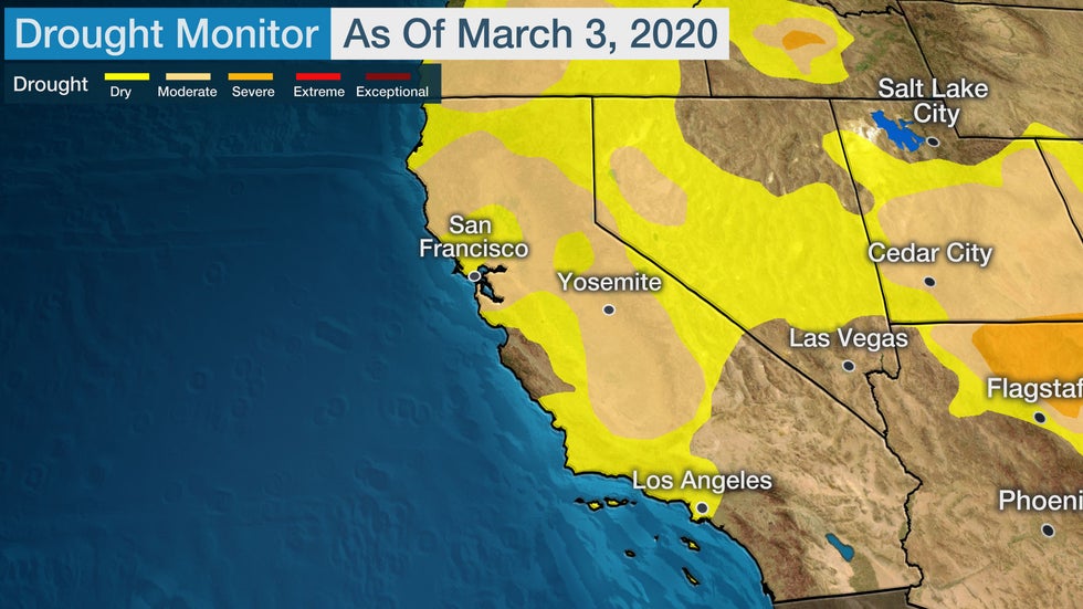
Reservoirs remain in fairly good shape, but the snow-water equivalent (how much water is in the snowpack) in the Sierra Nevada is about half of what is expected at this time of year.
The question is if a wetter pattern will return before the dry season begins.
Rain, Snow Ahead?
There is some good news. The upper-level ridge of high pressure will slowly shift away from California this week. This will allow a cold front to move through Northern California Friday into Saturday.
This first system is not particularly strong and will bring limited moisture to California. Most of the precipitation will fall in the Pacific Northwest, but a few rain and snow showers are possible in parts of California.
Little rain or snow accumulation is anticipated in the Golden State from this first disturbance.
 Friday Night's Forecast
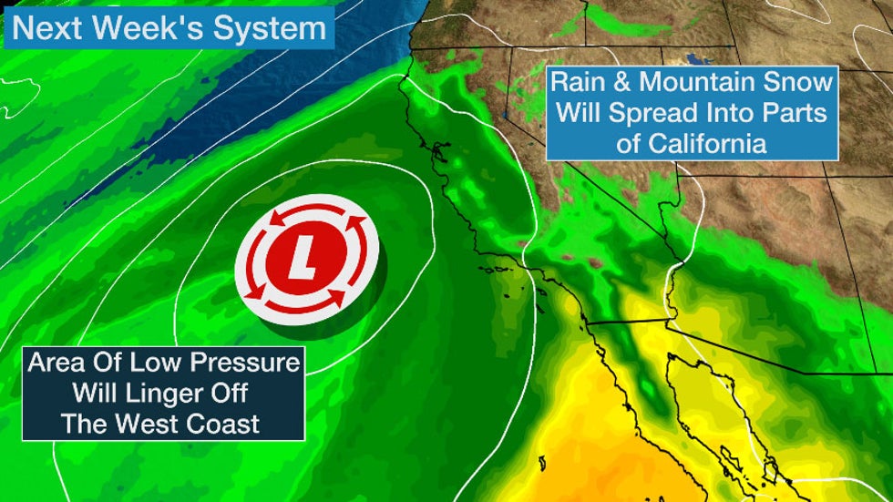
Another, stronger system will approach the California coast early next week.
This area of low pressure may track close enough to spread rain and mountain snow into the Golden State, and it may linger in the region for a couple of days. There could also be some tropical moisture associated with this system, which could enhance precipitation totals.
However, there remains notable uncertainty in how much, where and when precipitation may fall, so be sure to check back to weather.com for updates in the days ahead.
Still, the dry streak that began in late January in both San Francisco and Sacramento could finally end because of the upcoming chances of rain and snow.
San Francisco last had measurable rainfall on Jan. 28. Only 8.83 inches of precipitation has been measured in downtown San Francisco since Oct. 1, which is more than 9 inches below average.
The fourth-longest midwinter dry spell on record is currently occuring in San Francisco, the National Weather Service noted. If at least 0.01 inches of rain falls, this would end that dry streak.

There are indications that a wetter pattern will generally be more likely heading into mid-March in California, which would also help alleviate some of the concerns associated with the recent dry pattern.
NOAA's Climate Prediction Center has highlighted Central and Southern California as having an above-average chance of precipitation in both the 6- to 10-day and 8- to 14-day outlooks.
 Precipitation Outlook
The Weather Company’s primary journalistic mission is to report on breaking weather news, the environment and the importance of science to our lives. This story does not necessarily represent the position of our parent company, IBM.
The Weather Company’s primary journalistic mission is to report on breaking weather news, the environment and the importance of science to our lives. This story does not necessarily represent the position of our parent company, IBM.


No comments:
Post a Comment