Jonathan Erdman
Published: March 5, 2020
The first day of astronomical spring is still two weeks away, but you wouldn't know it by the recent weather.
In the Northeast, despite a powerful lake-effect snowstorm at the end of the month, February was among the least snowy on record along the Interstate 95 urban corridor. Boston was the only major city in that corridor to receive any measurable snow.
Recent warmth eroded snowpack over the Lower 48 states to its lowest aerial coverage for March 4 in 16 years, according to NOAA's National Operational Hydrologic Remote Sensing Center – a stark contrast to the record-smashing cold and widespread snow cover in place one year ago.
And, according to the National Phenology Network, the spring leaf out is occurring as far north as parts of the mid-Atlantic, up to three weeks earlier than average.
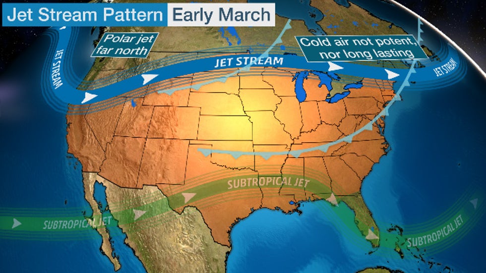
One reason for this benign winter was the tendency for the jet stream to steer cold, Canadian air eastward across North America, rather than plunging it deep into the U.S. and locking it in place, what meteorologists refer to as the positive phase of the Arctic Oscillation. A persistently strong polar vortex high above the Earth in the stratosphere likely was a factor in this pattern.
Also lingering into at least next week: the jet stream's southward dip in the West.
When that happens, the jet stream tends to buckle northward in the central and eastern U.S., allowing relatively warm air to push northward into the Plains, Midwest and East.
That doesn't mean cold fronts won't sweep through the country and knock temperatures down; That's just part of March's often frustrating weather.
But it does mean that warmer weather will dominate in much of the eastern two-thirds of the country over the next week or two. The colder air behind each front won't be all that cold, and it won't last long before a warmup ensues.
More Warm Weather Incoming
The next warm surge will spread across the Plains late this week, then into the Midwest and Northeast this weekend into early next week.
Friday's highs could approach 70 degrees as far north as Montana.
This weekend, Detroit and Minneapolis could have their first 60s – and Omaha its first 70s – since October.
 Forecast Highs
NOAA's latest 8- to 14-day outlook indicates virtually all of the central and eastern United States is expected to be warmer than average through the week of St. Patrick's Day, particularly in the Midwest, South and East.
 Long-Range Temperature Outlook
Spring Snow Still Possible?
This doesn't mean it's time to put the snow thrower away for the season.
From the interior Northeast across the Great Lakes into the Northern Plains, the season's final snow typically falls in April. In the Mountain West, that could occur in May or later.
Last spring, Chicago had its snowiest April since 1982, with separate snow events on April 14, Palm Sunday, then again on April 27.
So we can't rule out one or more potent spring snowstorms that may have just enough cold air to blanket the ground with heavy, wet snow.
But for at least the next couple of weeks, that chance seems small east of the Rockies.
And this stubborn jet stream pattern would have to change appreciably to allow winter weather to make a comeback in April.
The Weather Company’s primary journalistic mission is to report on breaking weather news, the environment and the importance of science to our lives. This story does not necessarily represent the position of our parent company, IBM.
The Weather Company’s primary journalistic mission is to report on breaking weather news, the environment and the importance of science to our lives. This story does not necessarily represent the position of our parent company, IBM.


No comments:
Post a Comment