Tuesday, March 31, 2020

Idaho hit by strong magnitude 6.5 earthquake

Updated Mar. 31, 2020 9:07 PM


A preliminary magnitude 6.5 earthquake rattled Idaho on Tuesday with shaking felt across the region, including Washington state, Utah, Nevada, and Canada. 
Tuesday's quake was the strongest in the state since the 1983 Borah Peak earthquake, which measured 6.9 on the Richter Scale. This earthquake was so strong that the eruptions of Old Faithful in Yellowstone National Park were noticeably longer
The epicenter of the earthquake was located approximately 78 miles (126 km) northeast of Boise and struck at 5:52 p.m. local time, according to the USGS.
A magnitude 4.8 aftershock hit shortly after approximately 23 miles (38 km) southwest of Challis, Idaho.
"Boise, yes you did feel an earthquake. City officials are checking all our facilities and public safety officers are conducting structural checks downtown and in our neighborhoods," Boise Mayor Lauren McLean said in a Twitter post.
The Boise Police Department said there are no reports of damage yet.
There are reports of shaking felt in Emigrant, Montana, which is approximately 30 miles north of Yellowstone National Park. 
People took to social media to share videos and comments about the quake. One Twitter user tweeted a video of a chandelier swaying saying the earthquake was felt more than 500 miles away in Kelowna, British Colombia, Canada.
This is a developing story, continue to check back for more details.
Keep checking back on AccuWeather.com and stay tuned to the AccuWeather Network on DirecTV, Frontier and Verizon Fios.

Snow Will Blanket Parts of Rockies, Plains to Start April, the Snowiest Month for Some

April is the snowiest month of the year in parts of the Rockies and High Plains, and right on schedule, a storm will head their way.
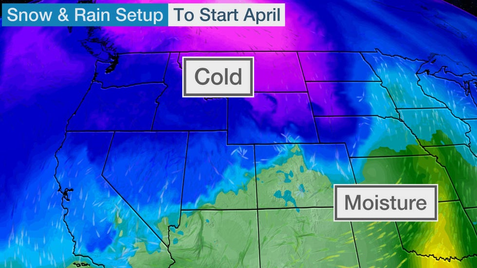
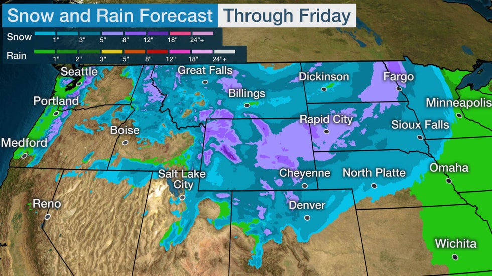
A storm system will sweep eastward across northern and central portions of the Rockies and the Northern Plains through Friday. With cold air in place, accumulating snow is expected in those regions.
The higher elevations of the northern Rockies are expected to pick up the most snowfall, with perhaps a foot or more in parts of the chimney of Idaho, western Montana and western Wyoming.
At least 5 inches are possible in a stripe from eastern Wyoming to South Dakota, eastern North Dakota and northwestern Minnesota. Most other areas from the northern and central Rockies to the northern and central High Plains will likely receive less than 5 inches.
Denver could pick up some light accumulating snow later Thursday or Thursday night.
Snow and Rain Forecast

Where April Is the Snowiest Month

There are nearly three dozen locations where April is typically the snowiest month, according to Dr. Brian Brettschneider, a climatologist at the University of Alaska Fairbanks who examined monthly snowfall data from 4,218 U.S. observation sites that receive a yearly average of at least 2 inches of snow.
Locations where April is the snowiest month, or tied for the snowiest month, on average.
These locations are all in the northern or central Rockies and the adjacent High Plains, particularly the Black Hills of South Dakota, which is known for both very early and very late in season heavy, wet snowstorms.
Among those locations:
  • Casper, Wyoming: 11.6 inches
  • Mount Rushmore, South Dakota: 11.3 inches
While not its snowiest month, Lead, South Dakota, averages 32.9 inches of snow each April and was buried in 86.7 inches of snow in April 1984.
Average snowfall from April through June based on 1981-2010 data.
Brettschneider found that while the lion's share of cities have their snowiest month in the core winter months of December through February, just under 500 locations are snowiest either in the fall (October or November) or spring (March or April).
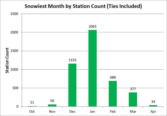
Histogram of the distribution of snowiest months of all U.S. reporting stations with at least 2 inches of snow. For example, March is the snowiest month for 377 reporting stations. In the case of a tie for the snowiest month, each tied month is counted for each station.

Recent April (and Later) Snowstorms

Last April, Winter Storm Wesley brought a blizzard to the High Plains, more than 2 feet of snow to the Dakotas, an ice storm to parts of several Midwestern states and even a dust storm to the southern High Plains.
In 2018, Winter Storm Xanto dumped record snow for the month of April on parts of the upper Midwest and Great Lakes, including Minneapolis-St. Paul and Green Bay, Wisconsin.
Xanto brought 15.8 inches of snow to Minneapolis-St. Paul April 13-16, 2018, making it the heaviest April snowstorm on record there. It was the 12th-heaviest snowstorm of all-time in the Twin Cities. Winter Storm Xanto pushed Minneapolis-St. Paul to its snowiest April on record, with 26.1 inches of snow.
Green Bay picked up 24.2 inches of snow from Xanto April 13-16, 2018, ranking not only as the city's heaviest April storm, but also the second-heaviest snowstorm of all-time. Blizzard conditions were observed in Green Bay from 11 a.m. to 2 p.m. CDT on April 15.
In mid-April 2016, Winter Storm Vexo dumped over 4 feet of snow in the foothills west of Denver and a foot in the city.
Three years before that, in early-April 2013, Winter Storm Walda was one of the most bizarre April snowstorms of recent history, not only burying the Black Hills of South Dakota in several feet of snow, but producing freezing rain as far south as northwestern Texas and a crippling ice storm in parts of South Dakota and Iowa.
At left: Doppler radar just before 7 a.m. CDT April 10, 2013, showing areas of freezing rain from northwestern Texas to South Dakota. At right: Ice storm photo from April 9, 2013, in Sioux Falls, South Dakota.
An April 1-5, 1987, slow-moving low-pressure system led to heavy snowfall accumulation in the Appalachians. High winds produced snow drifts of more than 10 feet, and with the weight of the heavy snow, led to downed trees and power lines and some roof collapses.
As it turns out, three of the top-five Category 5 winter storms in the Northern Rockies and Plains, as classified by NOAA's Regional Snowfall Index, occurred in April.
The most recent case was a four-day, late-April 1984 blizzard, dumping 3 to 6 feet of snow in the Black Hills of South Dakota, mountains of northern Wyoming and southern Montana.
We've also had two notable May snowstorms in recent history.
Winter Storm Venus pounded the Rockies and High Plains as Tropical Storm Ana was making landfall in South Carolina on Mother's Day weekend in 2015.
The previous Mother's Day, in 2014, Winter Storm Zephyr was the latest and heaviest snowstorm of record in Cheyenne, Wyoming, and dumped a few slushy inches of snow in Denver.
The Weather Company’s primary journalistic mission is to report on breaking weather news, the environment and the importance of science to our lives. This story does not necessarily represent the position of our parent company, IBM.
The Weather Company’s primary journalistic mission is to report on breaking weather news, t

Why 2019's Hurricane Dorian Wasn't Retired by the World Meteorological Organization

Brian Donegan and Chris Dolce
Published: March 31, 2020
There have been 89 hurricane or tropical storm names retired from future use in the Atlantic Basin, but Hurricane Dorian will not be the 90th entry on that list – at least not this year – despite the disastrous impacts it caused in 2019.
Atlantic tropical cyclone name lists repeat every six years unless a storm is so severe that the World Meteorological Organization (WMO) hurricane committee votes to retire that name from future lists. This avoids the use of, say, Harvey, Katrina, Maria or Sandy to describe a future weak, open-ocean tropical storm.
The WMO committee usually holds a weeklong meeting every spring, but due to the ongoing COVID-19 pandemic, this year's meeting was canceled several weeks ago, according to Dennis Feltgen, Communications and Public Affairs Officer at the National Hurricane Center.
Instead, the hurricane committee members met for a few hours Tuesday morning via videoconference, Feltgen said, noting that there was no discussion about the potential retirement of any names from the 2019 Atlantic hurricane season. The agenda was strictly about the upcoming 2020 season.
The next scheduled meeting of the hurricane committee is in spring 2021, when the potential retirement of any 2019 and 2020 hurricane names will be included in the discussions.
While all we can do is speculate, it seems likely that the WMO will retire Dorian at their annual meeting next spring. We can also argue for the retirement of Imelda and Lorenzo. Here's why.

2019's Potential Retirees

Dorian
Dorian's two-week rampage through the Atlantic caused damage from the eastern Caribbean to Nova Scotia, Canada, but its most devastating impacts were in the northern Bahamas, where it struck as a Category 5.
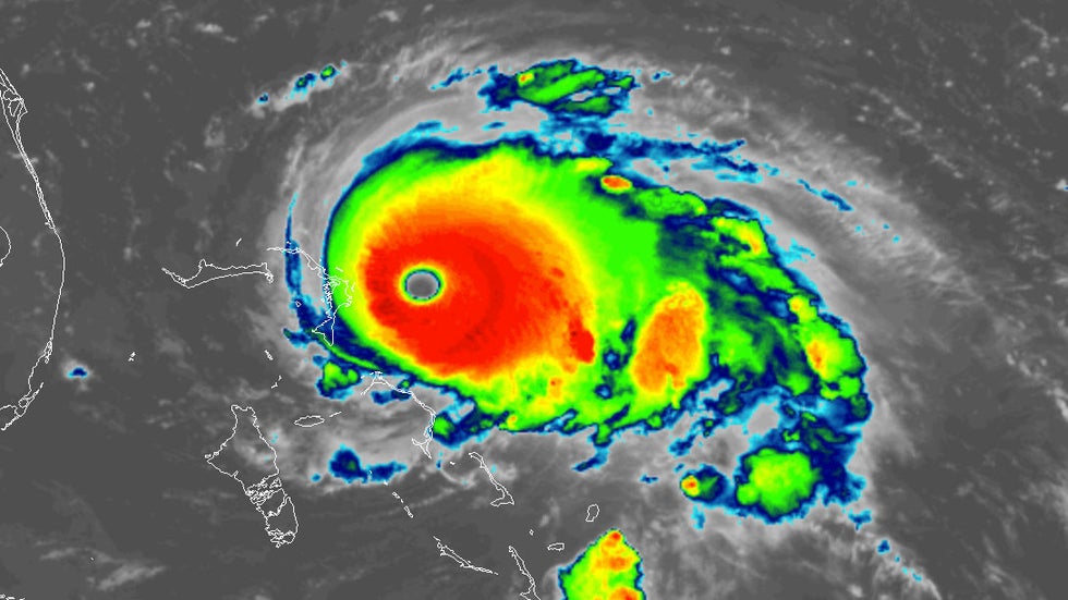
Hurricane Dorian when it first became a Category 5 on Sept. 1, 2019.
Dorian's maximum sustained winds jumped from 150 to 185 mph in 12 hours early Sept. 1. That increase in winds coincided with Dorian's landfall on Great Abaco Island in the Bahamas.
The northwestern Bahamas suffered catastrophic damage from extreme winds and storm-surge flooding. Those impacts were worsened by the fact that Dorian slowed to a crawl, with its eyewall lashing the northwestern Bahamas for 51 straight hours.
Dorian's curling, parallel track off the southeastern U.S. coast was just far enough offshore to prevent significant impacts in Florida and Georgia. It eventually made landfall in North Carolina's Outer Banks as a Category 1 hurricane. The total cost of the damage from storm-surge flooding, rainfall flooding and tornadoes in the U.S. was $1.6 billion, according to NOAA.
Imelda
Tropical Storm Imelda proved once again why a potent hurricane is not required for disastrous impacts.
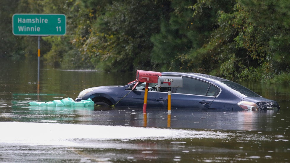
A car sits in floodwaters on Highway 124 on Sept. 20, 2019, in Beaumont, Texas.
Imelda was a short-lived storm that formed and made landfall on the upper Texas coast in a matter of a few hours. The storm then meandered through southeastern Texas, where it brought extreme rainfall and major flooding.
Rainfall totals exceeded 30 inches in several counties of southeastern Texas. The maximum total was 44.29 inches south-southwest of Fannett, Texas.
Imelda's floodwaters caused $5 billion in damage, according to NOAA. Many thousands of homes, cars and businesses were inundated. Five deaths were blamed on Imelda's flooding.
If retired next year, Imelda would join only two other Atlantic retirees to never attain hurricane status. They were 2015's Tropical Storm Erika and 2001's Tropical Storm Allison.
Lorenzo
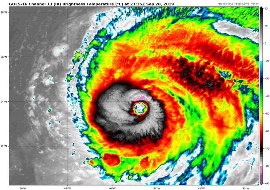
Hurricane Lorenzo intensified into a Category 5 on Sept. 28 in a region of the eastern Atlantic where no other hurricanes of that strength had ever been recorded.
Lorenzo eventually moved near the Azores in the northeastern Atlantic as a Category 1, where its strong winds and battering surf caused moderate damage, according to the National Hurricane Center.
There were 19 direct deaths blamed on Lorenzo, but none of them were in the Azores.
The tugboat Bourbon Rhode sank when Lorenzo was rapidly intensifying in the Atlantic. All 11 crewmembers on the boat were killed.
An additional eight deaths along the U.S. East Coast were blamed on rip currents and dangerous surf conditions generated by Lorenzo's swells hundreds of miles away.

Retired Name History in the Atlantic Basin

Since the naming of Atlantic tropical cyclones ditched the phonetic alphabet in 1953, 89 Atlantic tropical cyclone names had been retired through 2018.
The most retirees for a single year was five during the hyperactive 2005 hurricane season. 2017 joined the 2004, 1995 and 1955 seasons with four retired names.
Only 19 seasons have not had a name retired, most recently in 2014. Another 25 seasons, through 2018, had multiple names removed from future use.
Names beginning with the letter "I" lead the retirees with 11, followed by nine "C" storms and nine "F" storms. Nine of those "I" storms have been retired since 2001 alone, including a four-year streak from 2001 through 2004 (Iris, Isidore, Isabel and Ivan, in that order). Wilma in 2005 is the latest-in-the-alphabet retiree.
Some names you'll instantly recognize. Others, not so much.
For example, Katrina, Rita and Wilma are the big three you probably remember from 2005. You might have forgotten about Dennis and Stan, however. Did you know Stan may have been more deadly than Katrina?
Previously retired Atlantic storms weren't all necessarily intense Category 3, 4 or 5 hurricanes. In fact, several were retired because of their deadly flooding in the Caribbean, Mexico, Central America or the U.S.
Some examples of this include 2018's Florence, 2017's Nate, 2013's Ingrid in Mexico, 1996's Hortense in Puerto Rico and 1972's Agnes in the eastern U.S.
The Weather Company’s primary journalistic mission is to report on breaking weather news, the environment and the importance of science to our lives. This story does not necessarily represent the position of our parent company, IBM.

The Weather Company’s primary journalistic mission is to report on breaking weather news, the environment and the importance of science to our lives. This story does not necessarily represent the position of our parent company, IBM.

Florida Wildfire Threat and Drought Increasing From a Record Hot, Dry March

Florida is searing through what could be a record dry and hot March, and that combination is raising the threat of wildfires and drought heading into the heart of the state's dry season.
If you're not at least a part-time Florida resident, you may not know the state even has a dry season. From late October through early May, the state typically doesn't receive the type of daily downpours that have soaked many a summer afternoon at the beach or theme parks.
Even though March is in the heart of this drier time of the year, parts of Florida are threatening records with virtually no rain all month.
Tampa International Airport hasn't picked up any measurable rain since Leap Day. If this holds, it would be only its third March on record without at least 0.01 inches of rain (2006 and 1907 were the others).
This map of March rainfall through March 30, 2020, shows parts of the Florida Peninsula have been almost completely dry while other parts of the South have been soaked.
Daytona Beach, Fort Myers, Key West and Orlando haven't fared much wetter, with each managing only a paltry 0.02 inches so far. Daytona Beach is on pace to break its record-dry March in 2006, when only 0.08 inches were measured.
In fact, parts of the Florida Peninsula have been the driest locations anywhere in the Lower 48 states in March, according to an analysis from NOAA, drier than even Death Valley, California (0.28 inches).
In March, high pressure has been persistent and strong near the Gulf Coast and Florida, steering frontal systems generally north of the Sunshine State and suppressing rain.
It has also produced summerlike heat.
According to the Southeast Regional Climate Center, Daytona BeachOrlando and Pensacola were each on pace for their hottest March on record.
Jacksonville crushed its March all-time record high on Saturday by soaring to 94 degrees. Fort Myers' nine days of 90-degree-plus heat more than doubled its previous March record from 1949.
Daily high and low temperatures in March 2020 through March 30 in Fort Myers, Florida. The area shaded in brown denotes the average range of daily temperatures in Fort Myers in March.
The first cold front since early March will sweep through the Florida Peninsula into early Wednesday, providing relief from this recent March heat wave.
But, true to form for the dry season, it won't bring soaking relief.
Scattered thunderstorms are most possible along the Interstate 10 corridor of North Florida and the Panhandle.
The rest of Florida may have a few showers along and ahead of the front, but rainfall totals will be light.
(FORECAST MAPS: 10-Day Highs/Lows | Rain Next 48 Hours)

Fire Danger and Developing Drought

This persistently dry, hot pattern has dried out soil and vegetation.
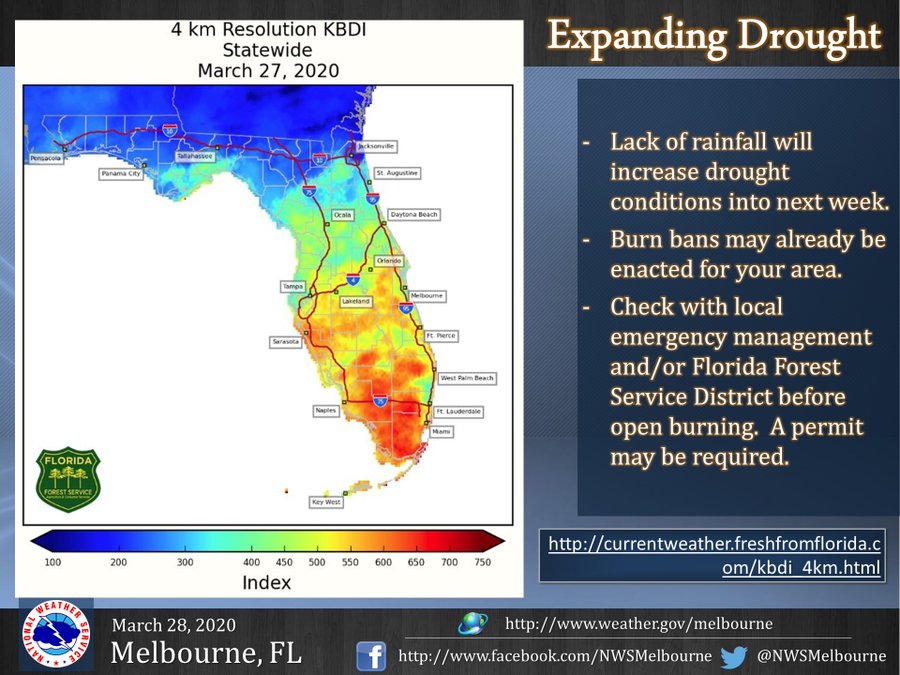
This typically happens in spring, but the extreme lack of March rain and blistering heat raised the fire danger much higher, particularly south of Interstate 4. This is illustrated by one index used by fire-weather forecasters known as the Keetch-Byram drought index (KBDI).
As of Tuesday, 87 wildfires were active across the state and had burned just over 2,000 acres, according to the Florida Division of Emergency Management.
One wildfire in Bay County, northeast of Panama City, charred over 100 acres last weekend. Compounding the wildfire danger in the Florida Panhandle was the 2.8 million acres of damaged or downed trees from Hurricane Michael, providing fuel and making access to existing fires more difficult, according to the Florida Forest Service.
Burning bans were implemented in Alachua, Brevard, Manatee and Osceola counties, in addition to Duval, Hillsborough, Orange, Pinellas and Sarasota counties, where outdoor burning is banned year-round by county ordinance.
The aforementioned cold front's stronger winds and potential for lightning strikes in any thundershowers could be problematic for starting new wildfires or spreading existing ones, despite cooler temperatures and increased humidity.
As of March 24, only a few areas in Florida were considered in drought, according to the Drought Monitor analysis. Much of the state was considered abnormally dry.
The state's wet season, when heat and humidity build and ignite more frequent soaking thunderstorms, usually kicks into gear later in May.
If high pressure remains stubbornly in place until then, the Sunshine State could be in for a challenging spring of wildfires.
The Weather Company’s primary journalistic mission is to report on breaking weather news, the environment and the importance of science to our lives. This story does not necessarily represent the position of our parent company, IBM.
Man missing at sea for nearly 2 weeks found alive in life raft off Washington coast

  One of two men missing at sea for nearly two weeks was found alive on Thursday by a Canadian fishing boat in a life raft in Canadian water...