April is the snowiest month of the year in parts of the Rockies and High Plains, and right on schedule, a storm will head their way.
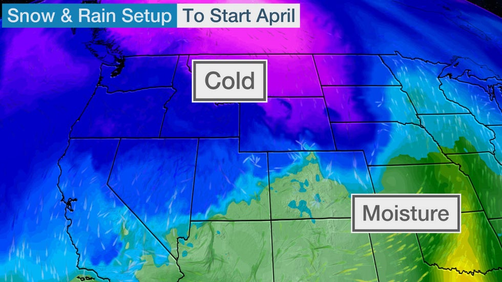
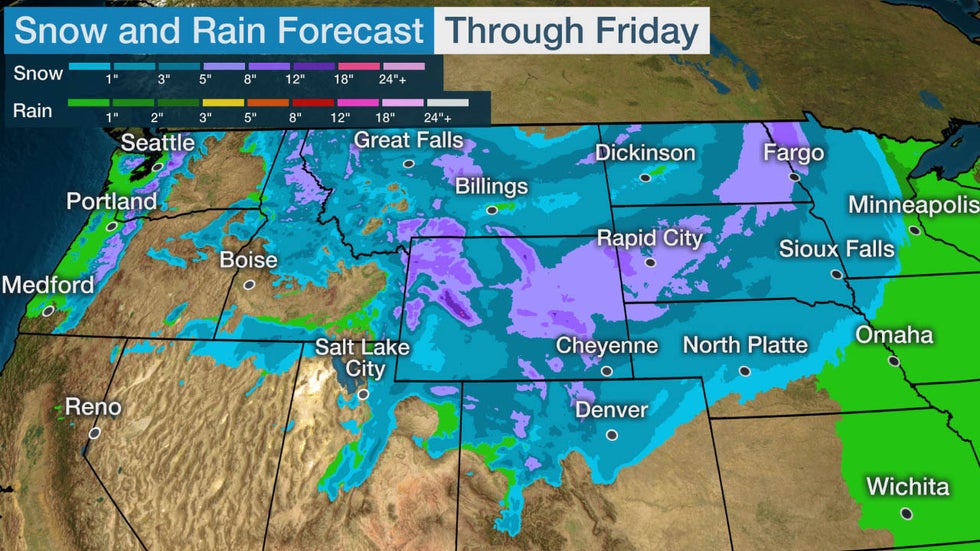
A storm system will sweep eastward across northern and central portions of the Rockies and the Northern Plains through Friday. With cold air in place, accumulating snow is expected in those regions.

The higher elevations of the northern Rockies are expected to pick up the most snowfall, with perhaps a foot or more in parts of the chimney of Idaho, western Montana and western Wyoming.
At least 5 inches are possible in a stripe from eastern Wyoming to South Dakota, eastern North Dakota and northwestern Minnesota. Most other areas from the northern and central Rockies to the northern and central High Plains will likely receive less than 5 inches.
Denver could pick up some light accumulating snow later Thursday or Thursday night.
 Snow and Rain Forecast
Where April Is the Snowiest Month
There are nearly three dozen locations where April is typically the snowiest month, according to Dr. Brian Brettschneider, a climatologist at the University of Alaska Fairbanks who examined monthly snowfall data from 4,218 U.S. observation sites that receive a yearly average of at least 2 inches of snow.
 Locations where April is the snowiest month, or tied for the snowiest month, on average.
These locations are all in the northern or central Rockies and the adjacent High Plains, particularly the Black Hills of South Dakota, which is known for both very early and very late in season heavy, wet snowstorms.
Among those locations:
- Casper, Wyoming: 11.6 inches
- Mount Rushmore, South Dakota: 11.3 inches
While not its snowiest month, Lead, South Dakota, averages 32.9 inches of snow each April and was buried in 86.7 inches of snow in April 1984.
 Average snowfall from April through June based on 1981-2010 data.
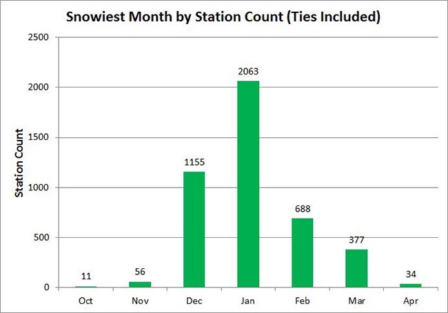
Brettschneider found that while the lion's share of cities have their snowiest month in the core winter months of December through February, just under 500 locations are snowiest either in the fall (October or November) or spring (March or April).
 Histogram of the distribution of snowiest months of all U.S. reporting stations with at least 2 inches of snow. For example, March is the snowiest month for 377 reporting stations. In the case of a tie for the snowiest month, each tied month is counted for each station.
Recent April (and Later) Snowstorms
Last April, Winter Storm Wesley brought a blizzard to the High Plains, more than 2 feet of snow to the Dakotas, an ice storm to parts of several Midwestern states and even a dust storm to the southern High Plains.
In 2018, Winter Storm Xanto dumped record snow for the month of April on parts of the upper Midwest and Great Lakes, including Minneapolis-St. Paul and Green Bay, Wisconsin.
Xanto brought 15.8 inches of snow to Minneapolis-St. Paul April 13-16, 2018, making it the heaviest April snowstorm on record there. It was the 12th-heaviest snowstorm of all-time in the Twin Cities. Winter Storm Xanto pushed Minneapolis-St. Paul to its snowiest April on record, with 26.1 inches of snow.
Green Bay picked up 24.2 inches of snow from Xanto April 13-16, 2018, ranking not only as the city's heaviest April storm, but also the second-heaviest snowstorm of all-time. Blizzard conditions were observed in Green Bay from 11 a.m. to 2 p.m. CDT on April 15.
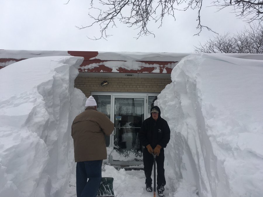
WOW! Incredible snow drift in Oconto Falls, north of Green Bay. Photo from Thomas Thomson #wiwx #AprilBlizzard
59 people are talking about this
In mid-April 2016, Winter Storm Vexo dumped over 4 feet of snow in the foothills west of Denver and a foot in the city.
Three years before that, in early-April 2013, Winter Storm Walda was one of the most bizarre April snowstorms of recent history, not only burying the Black Hills of South Dakota in several feet of snow, but producing freezing rain as far south as northwestern Texas and a crippling ice storm in parts of South Dakota and Iowa.
 At left: Doppler radar just before 7 a.m. CDT April 10, 2013, showing areas of freezing rain from northwestern Texas to South Dakota. At right: Ice storm photo from April 9, 2013, in Sioux Falls, South Dakota.
An April 1-5, 1987, slow-moving low-pressure system led to heavy snowfall accumulation in the Appalachians. High winds produced snow drifts of more than 10 feet, and with the weight of the heavy snow, led to downed trees and power lines and some roof collapses.
As it turns out, three of the top-five Category 5 winter storms in the Northern Rockies and Plains, as classified by NOAA's Regional Snowfall Index, occurred in April.
The most recent case was a four-day, late-April 1984 blizzard, dumping 3 to 6 feet of snow in the Black Hills of South Dakota, mountains of northern Wyoming and southern Montana.
We've also had two notable May snowstorms in recent history.
Winter Storm Venus pounded the Rockies and High Plains as Tropical Storm Ana was making landfall in South Carolina on Mother's Day weekend in 2015.
The previous Mother's Day, in 2014, Winter Storm Zephyr was the latest and heaviest snowstorm of record in Cheyenne, Wyoming, and dumped a few slushy inches of snow in Denver.
The Weather Company’s primary journalistic mission is to report on breaking weather news, the environment and the importance of science to our lives. This story does not necessarily represent the position of our parent company, IBM.
The Weather Company’s primary journalistic mission is to report on breaking weather news, t


No comments:
Post a Comment