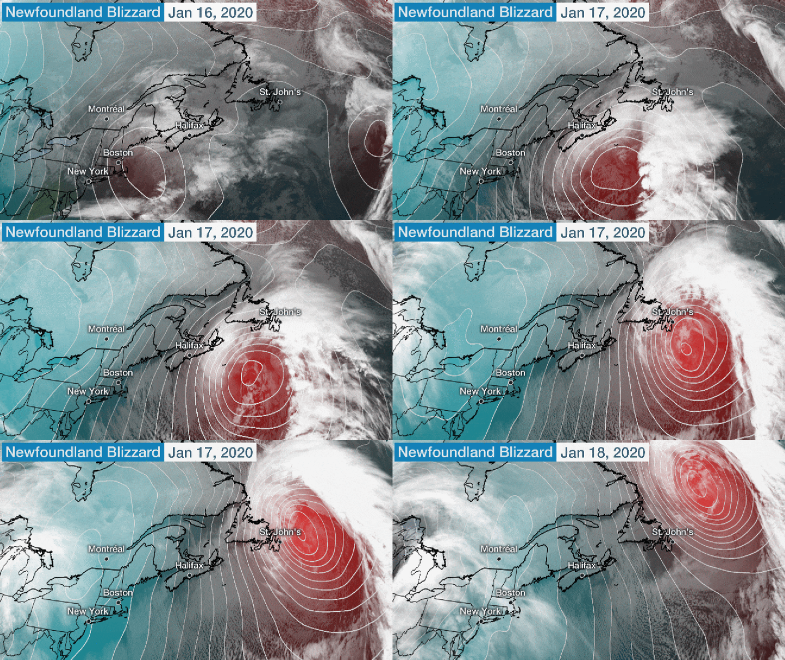
Parts of Newfoundland were buried in feet of snow from a crippling blizzard Friday and Saturday, smashing an all-time calendar-day snowfall record in a storm-prone part of Atlantic Canada.
St. John's Airport measured 76.2 centimeters - 30 inches - of snowfall Friday, their record snowiest single day dating to 1942, topping the previous record of 68.4 centimeters on April 5, 1999, according to Environment Canada.
The epic snow and wind gusts up to 97 mph whipped snow into massive drifts, burying vehicles, blocking roads, garages and doors of homes and filling backyards.
A 26-year-old man was reported missing in the blizzard conditions after he failed to return from a walk near his home in Conception Bay Friday afternoon.
A state of emergency was declared Friday in St. John's, which banned all but emergency travel and ordered businesses to close in the capital and largest city of Newfoundland and Labrador. Some 21,000 people were without power overnight, according to the Associated Press.
During the height of the storm, snowplow escorts were required for fire crews to reach emergency calls.
"We're getting roofs blowing off houses, people trapped in their cars - an assortment of everything, I'll say," Dean Foley, platoon chief of the St. John's Regional Fire Department told the CBC.
Roads were so clogged with snow at least one resident was transported by snowmobile to the hospital.
Some drifts were reported as high as 15 feet on Pitts Memorial Drive Saturday morning, according to the province's Department of Transportation and Works.
A small avalanche in The Battery, a neighborhood on the rocky slopes of Signal Hill northeast of downtown St. John's, punched through the kitchen and living room of one home, prompting the brief evacuation of a few dozen homes Friday evening, the CBC reported.
St. John's International Airport was shut down, with flight operations expected to be suspended until at least Sunday morning while crews worked to remove snow. Photos Saturday morning showed giant drifts in the airport's parking lots.
NTV chief meteorologist and southeast Newfoundland resident Eddie Sheerr tweeted, "This is the worst winter storm I have ever seen. Period."
The Bomb Cyclone
The system responsible for this historic Newfoundland blizzard moved off the coast of New England Thursday after dumping modest snow in upstate New York and northern New England.
The system then underwent a process known as bombogenesis where winds rapidly spreading apart at jet-stream level lead to a rapid intensification of the surface low.
According to analyses from NOAA's Ocean Prediction Center, the central pressure of the storm bottomed out at 954 millibars before sunrise Saturday morning, a 54 millibar pressure plunge in 42 hours from when it was a relatively pedestrian low over southern Vermont Thursday morning.

Atlantic Canada is no stranger to intense storms, which often plaster New Brunswick, Nova Scotia, then Newfoundland and Labrador after impacting the eastern U.S.
The extremity of the snowfall in such a short period of time, coupled with the ferocity of winds, made this is a storm residents in southeast Newfoundland won't soon forget.
The one-day snow total in St. John's was just shy of their average snowfall for an entire January - 88.7 centimeters.
Here are some other incredible photos from social media during this blizzard.
The Weather Company’s primary journalistic mission is to report on breaking weather news, the environment and the importance of science to our lives. This story does not necessarily represent the position of our parent company, IBM.
The Weather Company’s primary journalistic mission is to report on breaking weather news, the environment and the importance of science to our lives. This story does not necessarily represent the position of our parent company, IBM.

No comments:
Post a Comment