Updated Dec. 18, 2019 5:57 PM
As of 6:45 p.m. EDT Friday, this live blog is no longer being updated. Conditions have improved across the Carolinas as Dorian moves away from the region. Click here to see where Dorian is headed next.
Hurricane Dorian made landfall in the United States Friday morning. After flirting with landfall on the East Coast since Tuesday night, the storm officially came ashore in Cape Hatteras, North Carolina, at 8:35 a.m. EDT, the National Hurricane Center said.
Dorian made landfall as a Category 1 hurricane, maintaining maximum sustained winds of 90 mph. The hurricane stomped up the Eastern Seaboard causing widespread power outages, flooding and unleashing damaging tornadoes throughout the Carolinas.
There have been four Dorian-related deaths in the United States in the past week, officials have said -- three in Florida and one in North Carolina. Two of the deaths were victims who were preparing for the storm, according to The Associated Press. In addition, the death of an 80-year-old man was reported in Puerto Rico after falling from a ladder while climbing the roof of his residence to clean the drains as part of the preparations prior to the passage of Dorian.
Dorian was downgraded to a Category 1 hurricane on Friday morning after regaining major hurricane status during the middle of the week.
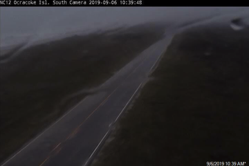
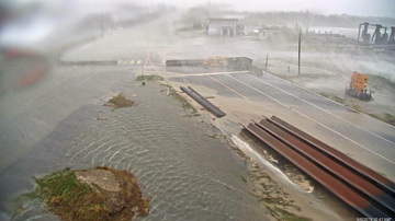
Despite losing wind intensity, the hurricane continues to pack a punch in terms of heavy rainfall, particularly in North Carolina's outer banks, where hundreds were stranded amid rising floodwaters on Ocracoke Island. "There is significant concern about hundreds of people trapped on Ocracoke Island,” North Carolina Gov. Roy Cooper said at a Friday press conference about the developing situation.
“There are rescue teams ready as soon as they can get in," the governor added.
Cooper said the island was subjected to significant storm surge and waters were "rising quickly there" as Dorian lashed the coastline. He urged people on the island to get to the highest points of their homes to avoid the deluge.
Significant rain totals were being recorded in various places around the state as Dorian swept through. Wilmington, North Carolina, picked up 8.58 inches on Thursday alone. The city normally receives 7.88 inches during the entire month of September.

Water levels were rising on beaches in Wilmington as high tide approached on Thursday. AccuWeather Digital Journalist Chaffin Dos Santos was in Wilmington reporting on the storm's worsening impacts as Dorian approached the city.
While there continues to be a risk of isolated tornadoes in eastern North Carolina and southeastern Virginia, this risk has substantially decreased since Thursday. A frenzy of tornadic activity came during the early morning hours of Thursday in southeastern North Carolina. The twisters resulted in numerous damage reports as the region continued to be pelted by Dorian's increasing winds, heavy rain and storm surge.
The National Weather Service's Storm Prediction Center reports 13 preliminary tornadoes in the area on Thursday, and this number may increase as crews survey additional damage. Video from Carolina Shores, North Carolina, showed homes ripped apart, RVs tossed on their sides and numerous trees uprooted.
Power outages increased as winds picked up speed, with nearly 190,000 customers without power in South Carolina Thursday evening, according to PowerOutage.US. While the number of power outages has since decreased in South Carolina, they are on the rise in North Carolina, with over 176,000 customers without power as of early Friday morning.
(AP Photo/Mic Smith)
1/17
Walker Townsend clears marsh grass from the Isle of Palms marina boat landing after Hurricane Dorian passed by the Isle of Palms, S.C., Friday, Sept. 6, 2019, in Charleston, S.C. Dorian sideswiped the Carolinas on Thursday, spinning off tornadoes that peeled away roofs and flipped recreational vehicles.
The destruction in the Carolinas was just the latest in the notorious storm's devastating history, which goes back to when the hurricane left historic and catastrophic damage in the northern Bahamas earlier this week , causing at least 30 deaths. Officials in the Bahamas expect the death toll to continue to increase.
Dorian's lifespan is expected to last into the weekend, as it is forecast to pound areas of the Northeast coast, then accelerate to the north where it will make landfall on Canada's Atlantic Coast.
RELATED:
Dorian makes landfall on Cape Hatteras, as mid-Atlantic coast continues to be battered with heavy rain and gusty windsOfficials call for humanitarian aid as death toll climbs in BahamasWhy Hurricane Dorian won’t be like Florence, thankfullyDramatic escape from hurricane floodwaters caught on video in Bahamas
4 p.m. EDT Friday:
As part of an initiative that seeks to help in the recovery of the Bahamas, Hampton University in Virginia is offering University of Bahamas students free tuition and housing for the fall semester. “Hampton has been the educational choice for many Bahamians over its long history. I am grateful to President Harvey and university leadership on this demonstration of kindness and humanity to my home in our time of need, ” said Lawrence Rigby, a student representative, in a press release.
5:30 p.m. EDT Friday:
Evacuations are starting on Ocracoke Island after people there were cut off from flooding rain and storm surge from Dorian. The island is only accessible by boat or by air. People that are evacuated will be taken to a shelter in Washington County, North Carolina, where they will have access to food, water, power, and medical supplies.
3 p.m. EDT Friday:
“Due to the conditions on Ocracoke Island, we are dispatching air transportation units to help evacuate residents that need to leave,” reads a press release by Hyde County in North Carolina. Earlier, Mike Sprayberry, NC Director of Emergency Management, said officials have received reports of people that may be trapped on the barrier islands in Dare and Hyde counties, CNN reports.
2:18 p.m. EDT Friday:
As Hurricane Dorian pulls away from the U.S., here's a look at the other tropical activity AccuWeather forecasters are monitoring for further development.

2 p.m. EDT Friday:
Dorian continued to lash the Outer Banks of North Carolina. In its 2 p.m. advisory, the National Hurricane Center said hurricane-force winds were reported in the Outer Banks.
1:31 p.m. EDT Friday:
Floodwaters from Dorian were inundating North Carolina's Outer Banks on Friday. Darrin Callihan, a charter boat captain in the Outer Banks, according to his Facebook page, posted multiple videos showing the raging floodwaters overwhelming a bridge. "Bridge is now floating[,] we are still fine but ready to be over it," he said in one video post . "Same as or worse than" Hurricane Matthew he observed in another.
12:03 p.m. EDT Friday:
Hundreds stranded in the Outer Banks on Ocracoke Island. "There is significant concern about hundreds of people trapped on Ocracoke Island,” North Carolina Gov. Roy Cooper said at a Friday press conference about the developing situation. “There are rescue teams ready as soon as they can get in." Cooper said the island was subjected to significant storm surge and waters were "rising quickly there" as Dorian lashed the coastline on Friday morning. He urged people on the island to get to the highest points of their homes to avoid the deluge.

11:42 a.m. EDT Friday:
"We're just entering the western eyewall. Take a look at the sheer power." AccuWeather National Reporter Dexter Henry was on Cape Hatteras in North Carolina Friday morning -- and live on the TV network! -- as Hurricane Dorian made landfall. Watch his full report, which included the calm inside the eye of the storm, here.

10:49 a.m. EDT Friday:
As Hurricane Dorian lashed the southeast coast on Thursday, it brought record rains to North Myrtle Beach in South Carolina. According to NWS data, 10.39 inches of rain fell there on Thursday -- nearly tripling its previous daily record of 3.61 inches set in 2008. The sun was back out and shining there late Friday morning, with RealfFeel temps at 85.
8:59 a.m. EDT Friday:
The National Hurricane Center officially declared that Dorian made its first United States landfall in Cape Hatteras, North Carolina at 8:35 a.m. after making three landfalls in the Bahamas. Current maximum sustained winds are at 90 mph.

6:36 a.m. EDT Friday:
Power outage totals in North Carolina continue to climb, as about 200,000 residents are waking up in the dark this morning. In South Carolina, over 150,000 people are still without power as well.
In North Carolina, the Greenville Utilities Commission told WNCT that it had to stop using bucket trucks because of the strong winds.
6:03 a.m. EDT Friday:
Dorian continues to brush against North Carolina as the eyewall is now moving across the Outer Banks, according to the National Hurricane Center. The hurricane-force winds are traveling northeast at 14 mph as the eye of the storm nears official landfall.
5:23 a.m. EDT Friday:
Maximum sustained winds from Dorian are lingering at 90 mph, with stronger gusts being reported at coastal locations. Winds from the eyewall are extending outward 45 miles.
The National Hurricane Center is predicting areas of southeast Virginia and northeast North Carolina to receive up to eight inches of rain total.
4:30 a.m. EDT Friday:
The western eyewall of Dorian is over Cape Lookout, North Carolina, according to the latest update issued by NHC. The hurricane has not officially made landfall, however.
Even if the storm does not officially make landfall in Cape Lookout, AccuWeather meteorologists believe a landfall will occur on Cape Hatteras later Friday morning.

2:50 a.m. EDT Friday:
Wilmington, North Carolina, has picked up nearly 9 inches of rain in the past 24 hours due to Dorian. Rain and wind will gradually wind down in the area as Dorian sweeps farther northeastward throughout the morning.
1:15 a.m. EDT Friday:
Dorian has been downgraded to a Category 1 hurricane in the latest update from the National Hurricane Center as maximum sustained winds are measured around 90 mph.
A weather station in Pamlico Sound, North Carolina, reported sustained winds of 51 mph with a wind gust reaching 70 mph, while another weather station at Cape Lookout, North Carolina, reported a sustained wind of 46 mph and a wind gust to 73 mph as Hurricane Dorian continues to churn off the coast.
11 p.m. EDT Thursday:
The death toll in the Bahamas has risen to 30, according to the Associated Press.
In the latest advisory from the National Hurricane Center (NHC), Hurricane Dorian is picking up speed and is now moving at about 13 mph as it continues on its northeastward track. Maximum sustained winds remain at 100 mph.
The NHC reports that the Canadian Hurricane Center has issued a hurricane watch for all of Nova Scotia. It has also issued a tropical storm watch for Prince Edward Island, the Magdalen Islands, New Brunswick from Fundy National Park to Shediac as well as Newfoundland from Francois to Boat Harbor.
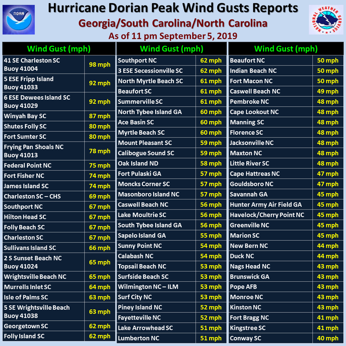
The top wind gust of 98 mph was reported by a buoy about 40 miles off the coast from Charleston, South Carolina. Closer to the coast wind gusts reached near 90 mph.
8 p.m. EDT Thursday:
The eyewall of Hurricane Dorian has tracked about 30 miles south of Cape Fear, North Carolina, with maximum sustained winds of 100 mph.
7 p.m. EDT Thursday:
The death toll in the Bahamas has risen to 23, according to the New York Times, as rescue efforts continue. This number is likely to continue to rise in the coming days and possibly weeks.
6:40 p.m. EDT Thursday:
A tropical storm warning has been issued for Cape Cod, Martha's Vineyard and Nantucket, Massachusetts, due to the anticipated impacts from Dorian. The hurricane is forecast to pick up speed as it tracks up the coast of the eastern United States, grazing coastal areas of the Northeast.
5:30 p.m. EDT Thursday:
The National Hurricane Center said Dorian's sustained wind speeds dropped to 105 mph early Thursday evening, and its forward speed accelerated to 10 mph as the storm churned south-southeast of Myrtle Beach.

5:15 p.m. EDT Thursday:
That Jeep is not going to make it! The vehicle got stuck in the Myrtle Beach surf as Hurricane Dorian hit the Carolinas. Authorities found the car locked and abandoned, but there is not much they can do due to the bad weather conditions.

5:00 p.m. EDT Thursday:
Duke Energy, which provides power across the southeastern U.S., announced Thursday it shut down both reactors at its Brunswick Nuclear Power Plant in North Carolina, in advance of Dorian's strongest winds.
4:30 p.m. EDT Thursday:
After Dorian pulled out of Florida, hot air came rushing in. Check out some of the AccuWeather RealFeel temps across the state -- 105 in Tallahassee, 101 in Miami, 102 in St. Augustine, and 101 in Melbourne.

4:15 p.m. EDT Thursday:
North Carolina Gov. Roy Cooper urged citizens who feel impacts from Dorian to stay home and stay safe. At the moment, the state has activated 527 members of the North Carolina National Guard and has opened 68 shelters, which had more than 2,200 people in them.
3:30 p.m. EDT Thursday:
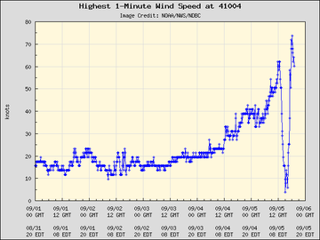
"From calm winds and birds flying in the eye to near blackout conditions," said NOAA about one of their buoys, which is now in the southern eye wall of Dorian. The images speak for themselves:
3:00 p.m. EDT Thursday:
South Carolina Secretary of Transportation, Christy A. Hall, informed some of the strategies implemented by the state to mitigate the impact of Dorian in the region:

2:30 p.m. EDT Thursday:
“We are calling for voluntary evacuation for those areas of the city that traditionally are impacted by mayor northeastern storms, northeasters and tropical storms …,” said in a press conference Tom Leahy, Virginia Beach Interim City Manager, as he announces a mandatory evacuation for citizens in Sandbridge effective 6 p.m. on Thursday.
2 p.m. EDT Thursday:
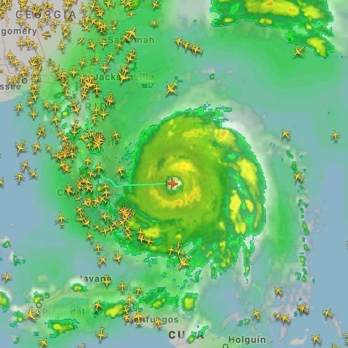
FUN FACT ALERT 🚨 When a hurricane approaches, all air traffic deviates from the storm, except hurricane hunters from NOAA and the Air Force Reserve.
1:45 p.m. EDT Thursday:
The U.S. Army Corps of Engineers announced on its Twitter page that approximately $18 million is being assigned to cover regional activation, temporary emergency power, temporary housing, and temporary roofing, among other issues that are related to the Dorian emergency.
12:37 p.m. EDT Thursday:
Over 250,000 residents in South Carolina are now without power due to Hurricane Dorian, according to poweroutage.us.
Over 10,000 others in Georgia and Florida also find themselves without power.
According to Santee Cooper, a company that provides electricity to customers in Berkley, Georgetown and Horry counties, utility crews were forced to scale back recovery efforts as heavy winds picked up.
12:22 p.m. EDT Thursday:
In North Carolina, police criminally charged numerous people for not following mandatory evacuation orders, according to Wrightsville Beach Police Chief Dan House. Numerous areas of the city were heavily damaged today by a tornado touching down at the Boardwalk RV Park.
Heavy rain, tornado warnings and flash flood warnings have inundated the area. Flood concerns are particularly notable for areas around Horry County, where river flooding is a likely danger.
11:09 a.m. EDT Thursday:
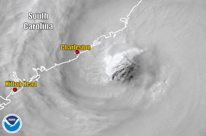
Hurricane Dorian weakened back down to a Category 2 storm with maximum sustained winds of 110 mph and continued to move north-northeast at 8 mph. NOAA satellites captured imagery of how close the eye came to Charleston, South Carolina -- just 50 miles.
11:05 a.m. EDT Thursday:
There have been 10 tornadoes reported on South Carolina and North Carolina over the past 24 hours as Hurricane Dorian closed in. Tornado watches remained in place for all coastal regions in both states.

10:25 a.m. EDT Thursday:
At Fort Sumter in Charleston, South Carolina, a 74-mph wind gust was recently recorded. Elsewhere in the city, Church Creek is nearly at minor flood stage while the city's downtown finds itself under water, forcing dozens of road closures.
For a list of older storm reports, click here for Wednesday reports and here for Tuesday reports.












No comments:
Post a Comment