Three more rounds of cold air will leave residents of the central and eastern United States shivering in the first half of November.
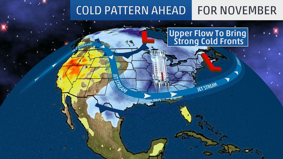
Cold temperatures have swept eastward behind a cold front to start the month, and the upper-level weather pattern will be favorable for additional blasts of cold air to infiltrate the U.S. into mid-November.
This upper-level pattern has brought a southward plunge in the jet stream over portions of the central and eastern U.S., which will allow colder than average temperatures to dive southward at times through the second full week of the month.
The first round of cold air early this week will be rather modest. However, a second, stronger blast of cold air will arrive mid- to late week. A third round of cold air will arrive early next week, but the magnitude of that one is uncertain.
Here's a closer look at each round of cold air ahead.
Round 1: Early This Week
This first round of cold air will mostly be confined to the Northern Plains, upper Midwest and Great Lakes.
Highs will be between 5 and 15 degrees below average in those regions Monday and Tuesday. This translates to afternoon temperatures in the 30s and 40s.
Lows will generally be 10 to 20 degrees below average in the Northern Plains, upper Midwest and Great Lakes early this week. This corresponds to temperatures dipping into the 20s and 30s overnight, with teens closer to the U.S.-Canada border.

Round 2: Mid- to Late Week
The next shot of cold air will slide into the northern Rockies and Northern Plains by Wednesday. This reinforcing cold air will then spread south and eastward into the rest of the Plains and Midwest on Thursday before reaching the South and East by Friday.

This second round of cold air will be stronger than the first. High and low temperatures will be 10 to 25 degrees below average when the cold air mass arrives.
Afternoon highs will be stuck in the 20s in the northern Rockies and Northern Plains Wednesday, then stuck in the 20s in the upper Midwest and northern Great Lakes Thursday and Friday. The Northeast will hold in the 30s Friday afternoon, while the mid-Atlantic struggles to rise out of the lower 40s.
High temperatures may hold in the 30s as far south as the Texas Panhandle on Thursday, with 40s as far south as Arkansas, Tennessee and North Carolina by Friday. Much of the South should hold in the 50s on Friday, except near the the Gulf Coast, where temperatures should still manage to reach 60 degrees.
The cold air will persist into Saturday east of the Mississippi River. New York City and Boston may struggle to rise out of the upper 30s Saturday afternoon. Even parts of North Florida will be relatively cool by Saturday, with some cities holding in the 60s.

Low temperatures will also be cold during this second blast of cold air.
Lows in the teens are likely in the Northern Plains, upper Midwest and northern Great Lakes Thursday and Friday mornings. Temperatures will dip into the 20s overnight as far south as the Texas Panhandle on Friday, with 20s stretching into Arkansas, Tennessee and North Carolina by Saturday.
The Northeast and mid-Atlantic will be in the 20s Saturday morning. Much of the South will dip into the 30s, and some upper 40s are possible in North Florida.
This cold air mass won't set many record lows, but a few record-cold highs are possible in the northern mid-Atlantic and the Northeast Friday and Saturday.
There is a chance that some moisture from a storm system in the South could overlap with this cold air from the Ohio Valley to the Northeast late this week. If that happens, some of these areas could have their first light snow event of the season. Click here for the latest forecast on this threat.
It should also be noted that as this cold air flows over the relatively warmer waters of the Great Lakes, lake-effect snow will likely develop in the typical snowbelt locations downwind of the lakes.
Round 3: Early Next Week
A third round of cold air will sweep into the central and eastern U.S. early next week, but the magnitude of this cold blast is uncertain.
The latest 8- to 14-day temperature outlook from NOAA's Climate Prediction Center indicates that the Midwest and Northeast have at least a 50% chance of below average temperatures from Nov. 11 to 17.

The chilly pattern may relax after the third cold shot early next week, but given the early season snowpack in Canada, prolonged warmth is unlikely in the northern tier heading into the second half of the month. This means that November 2019 might have below average temperatures prevail for many areas east of the Rockies.
Similar to November 2018?
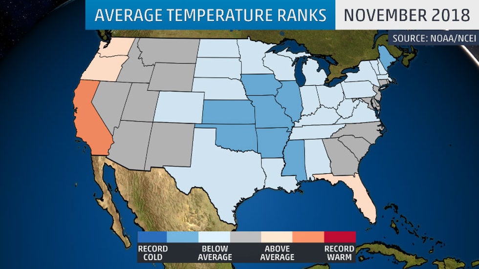
November 2018 was one of the 10 coldest Novembers on record for Illinois, Missouri, Arkansas, Oklahoma and Mississippi. Kansas City, Missouri, shivered through its coldest November on record.
The only warmer than average areas last November were found along the West Coast, and in Alaska and Florida.
The upper-level pattern last year also brought a persistent southward dip in the jet stream over the central and eastern U.S., which led to the chilly November for much of the country.
Last year's cold was also accompanied by a blizzard and record snow. However, it is too early to know if snowy conditions will also occur this November.
The focus of the most anomalous cold and its impacts this year may be in different locations than November 2018, but the overall pattern suggests that a chilly November may be ahead for the second year in a row.
The Weather Company’s primary journalistic mission is to report on breaking weather news, the environment and the importance of science to our lives. This story does not necessarily represent the position of our parent company, IBM.
The Weather Company’s primary journalistic mission is to report on breaking weather news, the environment and the importance of science to our lives. This story does not necessarily represent the position of our parent company, IBM.


No comments:
Post a Comment