By Brian Lada, AccuWeather meteorologist and staff writer
By Kevin Byrne, AccuWeather staff writer
Residents in several communities located near the swollen Mississippi, Missouri and Arkansas rivers were forced to flee their homes on Thursday and Friday following levee failures.
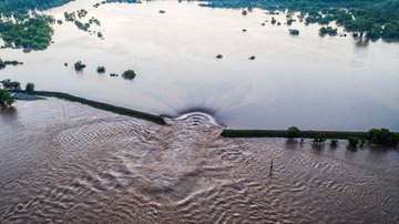
Residents in West Quincy, Missouri, are fleeing to higher ground due to a levee failure near the already bloated Mississippi River.
The levee breach took place along the Durgens Creek, which flows into the Mississippi River just upstream of West Quincy.
The Marion County Sheriff’s Office issued the evacuation orders for West Quincy, Taylor and Fabius Village shortly after 6:30 p.m. CDT Thursday.
“Emergency management reported flooding along the Durgens Creek in Lewis County. Water is expected to flow south into West Quincy. Move to higher ground now. Act quickly to protect your life,” the National Weather Service office in St. Louis said in a flash flood warning that was issued for the area.
Shelters are open for evacuees at the Mission Hill Church in Palmyra, Missouri, and the YMCA in Hannibal, Missouri.
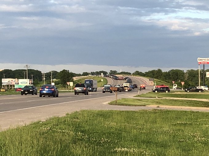
The Quincy Bayview Bridge was shut down for a time late Thursday to allow officials to respond to the levee failure and limit non-essential traffic into West Quincy, according to The Herald-Whig. The bridge has since reopened.
In a Friday morning Facebook post, Marion County Sheriff Jimmy Shinn said work continued all night to fight the problem area of the levee. Officials with the levee district are still advising that it remains a serious situation, he added.
"Our levee is being damaged by all the water coming down from the breach up north," Shinn told AccuWeather. "We are currently fighting it to protect our area. We have a hot spot that is still serious but are continuing to fight it and hold back waters."
The Mississippi River near Quincy is already in major flood stage and was less than a foot away from the all-time record level on Thursday night.
By Friday morning, new river gauge data showed the river had already dropped several feet.
 This graph shows the water level of the Mississippi River near Quincy, Illinois, on Saturday morning, June 1, 2019. (Image/NOAA)
This is the latest development in the ongoing flooding across the Mississippi River Valley.
In recent days, river gauges along the Mississippi River between Quincy and St. Louis have come within feet of their all-time record levels. There is the potential for some gauges to set new records as they crest.
Farther south, the Arkansas River, which flows through Oklahoma and Arkansas before emptying out into the Mississippi River, has swelled well out of its banks. Both states have declared a state of emergency in response to the flooding and are working with the Army Corps of Engineers to help to manage the water levels.
 The Arkansas River floods along Adams Street Thursday, May 30, 2019, in Van Buren, Ark. (AP Photo/Michael Woods)
Early Friday morning, the community of Holla Bend, Arkansas, located about 75 miles northwest of Little Rock, became endangered when the Dardanelle Levee breached shortly before 1 a.m. local time, according to KATV in Little Rock. Residents were told to evacuate immediately.
About 160 homes were under the evacuation order, according to the Associated Press.
Yell County Judge Mark Thone told KATV that the nearby community of Dardanelle is safe for now.
Dardanelle Mayor Jimmy Witt said on Facebook Friday morning that the city is preparing for a possible flooding situation coming from the bayou side.
"We will need both sandbagging operations going today and I ask you to please not panic, we have time to prepare for this. It will not be coming into our area for quite a while."
Witt had an update later in the morning that was positive for the community.
"The river level has come down to 45.15 [feet] at this time. That cant do anything but help us. We have a solid plan in place to help prepare with the water surge that may be coming. Please be patient and stay out of the areas where we will be working."
 This graph shows record river levels on the Arkansas River near Dardanelle, Arkansas, on Saturday morning, June 1, 2019. (Image/NOAA)
RELATED:
More rain during early June could push river levels higher, expand flooding in central US
It isn't your imagination, the weather has been extreme across the US -- and relief is in sight
A new AccuWeather analysis predicts a significant dropoff in 2019 crop yields
On Friday night, a flash flood warning was issued for central Pulaski County in Arkansas due to a potential levee breach. However, this warning was later canceled.
"The primary levee in North Little Rock is NOT in immediate danger," the National Weather Service said, citing local emergency management officials. "Rather, a containment berm was breached at a petroleum facility. The Flash Flood Warning was issued as a precaution and has since been canceled."
Meanwhile, in Howard County, Missouri, the Missouri River topped a levee on Friday. With the anticipated failure, officials issued mandatory evacuation orders for the river bottom from Petersburg to Rocheport, Missouri.
More than 300 roads in Missouri were underwater earlier this week, according to the Missouri Department of Transportation.
Unfortunately, the flooding along the Mississippi River basin is likely to get worse before it gets better.
AccuWeather meteorologists are expecting showers and thunderstorms to expand across the central U.S. again this weekend, followed by more rounds of rain through the first full week of June. Any additional heavy rain could make matters even worse in the region.
“It can take a month or more for runoff from heavy rain over the middle of the nation to flow to the Mississippi Delta,” AccuWeather Senior Metorologist Alex Sosnowski said.
Download the free AccuWeather app to see when rain will return to your area and to be alerted as severe weather approaches.
The levee breach took place along the Durgens Creek, which flows into the Mississippi River just upstream of West Quincy.
The Quincy Bayview Bridge was shut down for a time late Thursday to allow officials to respond to the levee failure and limit non-essential traffic into West Quincy, according to The Herald-Whig. The bridge has since reopened.

This is the latest development in the ongoing flooding across the Mississippi River Valley.

Early Friday morning, the community of Holla Bend, Arkansas, located about 75 miles northwest of Little Rock, became endangered when the Dardanelle Levee breached shortly before 1 a.m. local time, according to KATV in Little Rock. Residents were told to evacuate immediately.
Dardanelle Mayor Jimmy Witt said on Facebook Friday morning that the city is preparing for a possible flooding situation coming from the bayou side.

RELATED:
More rain during early June could push river levels higher, expand flooding in central US
It isn't your imagination, the weather has been extreme across the US -- and relief is in sight
A new AccuWeather analysis predicts a significant dropoff in 2019 crop yields


No comments:
Post a Comment