By Alex Sosnowski, AccuWeather senior meteorologist
May 19, 2018, 11:21:18 AM EDT
A plume of tropical moisture will raise the risk of flooding from the Carolinas to the mid-Atlantic, while downpours soak parts of the Midwest and rain spreads into New England this weekend.
Rain to reach northward into Saturday night
Downpours may develop, cluster and bring flooding to some counties in the East and barely dampen others.
Portions of the eastern Great Lakes and central and northern New England that have been spared from rain for a time this past week will join in with the wet weather as the moisture spreads northward through Saturday night.
There will be some gaps in the rainfall. The best bet for people with outdoor plans and projects is to monitor the radar on their mobile devices as the weather may be vastly different from the start of the day to the midday, afternoon and evening.
Motorists should be prepared to dodge flooded roads
The most common problem created by the downpours will be street and highway flooding.
RELATED:
WATCH: What to do if you have to drive in a flood
5 dangers to be aware of after a flood strikes
Preakness Stakes: Place your bets on mudders after rain creates sloppy track at Pimlico
Lightning strikes top of Empire State Building in New York
In case you missed it: Kīlauea blasts ash 30,000 feet into air; Severe storms kill nearly 200 in India
However, some small streams in the mid-Atlantic region will spill out of their banks. Motorists should never drive through flooded roads. Property owners along small streams should monitor water levels and take action as needed.
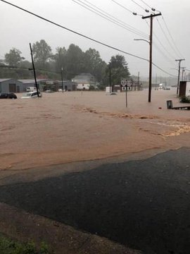
Heavy rain lead to major flooding around Martinsville, Virginia, on Friday afternoon. Numerous roads were closed due to flooding with some vehicles getting stranded in feet of water.
Some rivers will be on the rise
The combination of prior rain from this past week and additional rain on Saturday will cause minor to moderate flooding along the Potomac River, as well as portions of the Rappahannock in Virginia and the Millstone in New Jersey.

Most other major rivers in the region, such as the Susquehanna, Delaware and Ohio, should be able to handle the rainfall with little to no issues.
Timing the rainfall, travel delays
Sporadic airline delays are likely due to patchy early morning fog, an occasional low cloud ceiling and localized downpours.
Slow-moving, torrential downpours focused on an area from southern Virginia to the Delmarva Peninsula on Friday morning. One to three inches of rain fell in as many hours in some locations.
Although this batch of rain weakened as it moved northward, new clusters of heavy rain that developed over portions of Maryland, Virginia and the Delmarva on Friday night will move northward into the central and northern mid-Atlantic, as well as New England, through Saturday.

During Saturday, it may not rain much of the day from parts of central and southern Maryland to the Piedmont areas of Virginia and the Carolinas.
Few thunderstorms to prowl the Northeast
Some of the downpours in the Northeastern states in general will be accompanied by some thunder and lightning.
A small number of locations mainly south and west of New England and New York state may be hit by a gusty thunderstorm during the afternoon and evening hours on Saturday.
Drying trend may sputter at times
On Sunday, much of the rain is likely to exit the Atlantic coast with only very spotty showers in its wake.
A pocket of showers and thunderstorms may push eastward from Illinois, Wisconsin and Indiana to Ohio and the Lower Peninsula of Michigan.
During next week, just about every area east of the Mississippi River is likely to have at least a couple of days where it rains for a few hours.

However, longer stretches of dry weather are likely from the Great Lakes to the Northeast, especially during the middle and latter part of next week.


No comments:
Post a Comment