Wednesday, March 31, 2021

April Temperature Outlook: Warmer Than Average Conditions Expected for Much of the United States

 Linda Lam

Published: March 31, 2021


A warm April is expected for much of the U.S., according to the latest update issued by The Weather Company, an IBM Business.

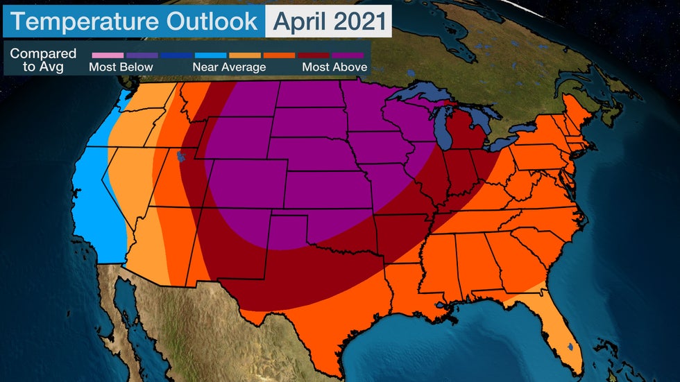
Temperatures will be the most above average in April from parts of the Rockies into the Northern and Central Plains and northern Great Lakes.

Areas along and closest to the West Coast will likely trend on either side of average in April.

Temperatures in the East are expected to be above average, although Florida will be near to slightly above average. Parts of the Northeast could be a bit cooler than indicated due to questions regarding how the upper-level pattern may evolve heading into mid-April.

Article image

"There is a cooler risk in the Northeast in April if North Atlantic blocking persists longer than expected," Todd Crawford, chief meteorologist with The Weather Company, noted.

S​hop the Winter Jacket Sale at Sierra Trading Post (SPONSORED)

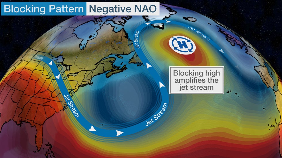
The blocking pattern referred to by Crawford is shown in the map below. In it, a ridge of high pressure over the North Atlantic near Greenland produces an amplified jet stream pattern, which could bring cooler temperatures southward from Canada into portions of the Northeast into the second week of April if it hangs around that long.

This blocking pattern coupled with the negative phase of the North Atlantic Oscillation will bring the quick blast of near record cold to the East as April begins.

(MORE: Cold Blast to Start April in the East)

Article image

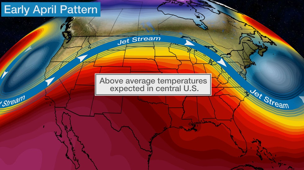
The jet stream pattern will bulge northward over the Plains in early April. This will result in a widespread area of warmer than average temperatures for at least the first half of the month.

Farther west, a southward dip in the jet stream may result in cooler temperatures for the West Coast in early April.

Article image

April's Typical Temperatures

Mild temperatures surge northward in April across the contiguous United States as we move deeper into spring.

Average highs in the 50s return for most of the northern tier, with 40s in northern Maine. Highs in the 80s become more common for parts of the Southwest, southern Texas and Florida.

G​ear up for Warmer Weather with Sierra Trading Post (SPONSORED)

Above average temperatures in April for much of the U.S. suggest fairly mild to warm temperatures are ahead for much of the month.

Article imageAverage April Highs

Many locations experience their last freeze of the season in April, although some locations in the northern tier, the higher elevations and the West wait until May.

Average low temperatures range in the 20s and 30s for much of the West, upper Midwest and Northeast. Lows in the 40s and 50s are typical for areas farther south, with 60s in central and southern Florida.

A milder than average April could bring fewer cold mornings but expect chilly conditions at times.

Article imageAverage April Lows

The Weather Company’s primary journalistic mission is to report on breaking weather news, the environment and the importance of science to our lives. This story does not necessarily represent the position of our parent company, IBM.

The Weather Company’s primary journalistic mission is to report on breaking weather news, the environment and the importance of science to our lives. This story does not necessarily represent the position of our parent company, IBM.

Twin Tornado Scars in Alabama Spotted From Space

 Chris Dolce

Published: March 30, 2021


Twin tornado scars can be seen from space in new satellite images over Alabama following last Thursday's destructive severe weather outbreak in the state.

Intense tornadoes that remain on the ground for a long distance have a higher chance of producing a damage path that's visible on satellite. That is particularly true in regions of the country where dense forests exist, like the Southeast.

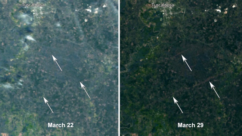
That's exactly what happened on March 25 to the south of Tuscaloosa, Alabama, when a pair of intense tornadoes carved their way through areas near and in Talladega Forest. You can see these scars in the comparison of images from the European Space Agency's Sentinel 3 satellite before (March 22) and after (March 29) the tornadoes struck.

Article imageLeft image shows the area on satellite before the tornadoes on March 22. The right image shows the two tornado scars (narrow brown shaded areas) on satellite on March 29.

The bottom two arrows show a portion of the scar from a tornado that was on the ground for an incredible 80 miles, from Hale County to Shelby County. It's estimated the twister lasted 98 minutes and was up to 1.3 miles wide.

In its post-storm survey, the NWS said, "Tens and tens of thousands of trees were snapped or uprooted. The volume and extent of snapped trees was incredible, pushing the rating to EF3." This tree destruction is the narrow brown shading you see through the forest in the after image from March 29.

Camping & Tactical Gear on Sale Now (SPONSORED)

You can see another smaller tornado scar highlighted by the top arrow. That twister also had a maximum rating of EF3, but lasted a much shorter distance of about 11 miles as it traveled from Hale County to Tuscaloosa County.

The tweet below from the National Weather Service in Birmingham shows the tracks of this pair of tornadoes as well as multiple others from March 25.

You can see the full track of the bottom tornado scar labeled as Sawyerville to Centreville to Columbiana. The top tornado scar is labeled as Elliots Creek.

There've been numerous examples of tornado scars appearing on satellite in recent years, including one last April in Mississippi.

One of the most notable examples is a tornado that struck northern Wisconsin more than a decade ago. Its path is still easy to spot, particularly in winter, when there is a contrast between snow on the ground and the surrounding forest that remains.

The Weather Company’s primary journalistic mission is to report on breaking weather news, the environment and the importance of science to our lives. This story does not necessarily represent the position of our parent company, IBM.

The Weather Company’s primary journalistic mission is to report on breaking weather news, the environment and the importance of science to our lives. This story does not necessarily represent the position of our parent company, IBM.

Two Iowa State University Students Die When Crew Club Boat Capsizes

 Ron Brackett

Published: March 30, 2021


A search Monday found the body of an Iowa State University student missing since the crew club boat he was in capsized Sunday morning. Another student's body was located Sunday, and three other crew members made it to shore.

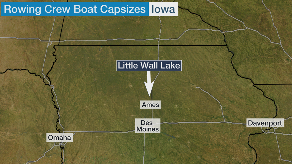
The five members of the rowing club were training on Little Wall Lake, about 15 miles north of Ames, Iowa, on Sunday morning when their boat capsized, according to a news release from the university.

Three of the students were rescued, and divers recovered the body of a fourth student, the Iowa State Daily reported.

The search for the fifth person continued until 9 p.m. Sunday, the Des Moines Register reported. It resumed Monday morning. Investigators found the body on a side of the lake using sonar technology, WOI-TV reported.

The body was recovered about 9:45 a.m., before strong winds caused weather conditions to deteriorate, the Iowa State Daily reported. Hamilton County Sheriff Doug Timmons said choppy waters and cold water temperatures would have made it more dangerous for divers.

The names of the students have not been released.

(MORE: Flooding Kills 5 in Tennessee, Forces Evacuations in Kentucky)

Timmons told the ISD his office received a 911 call at about 9:30 a.m. Sunday. Several people who live around the lake helped rescue some of the students, he said.

"We've also had several heroes that live in the buildings out here, came out and help the individuals," Timmons said. "This could have been a lot worse than what it is, what it's going to be."

Roger Fritz lives on the lake's west side. He said in a tweet that he saw one person swim to the south shore and one to the north. Another person was rescued by someone in a kayak, he said.

"My guess is the water is about 40 degrees," Fritz tweeted. Emergency scanners mentioned patients with hypothermia.

Scott Grummer, a fisheries biologist with the Iowa Department of Natural Resources said the water temperature was 39 to 42 degrees near the shore.

The air temperature at 8:30 a.m. at the Ames Municipal Airport was 37 degrees, according to the National Weather Service. The wind chill was 27 degrees, and the winds were blowing out of the northwest at 20 mph with gusts up to 29 mph, the NWS said.

The lake was still frozen over about two weeks ago, Fritz said in a Facebook Live video stream.

Sheriff Timmons said "the lake was pretty rough."

"I’m guessing they probably got swamped in some heavier waves," Fritz said. "Those crew boats are really shallow."

Little Wall Lake covers 249 acres, according to the Department of Natural Resources. It's 13.2 feet at its deepest point.

“The Iowa State community is heartbroken to learn of this tragic accident at Little Wall Lake," Wendy Wintersteen, the university president, said in a statement. "At this time, we are focused on providing support to club members, their families and friends. We ask that everyone keep them in their thoughts during this very difficult time."

Article image

The Weather Company’s primary journalistic mission is to report on breaking weather news, the environment and the importance of science to our lives. This story does not necessarily represent the position of our parent company, IBM.

The Weather Company’s primary journalistic mission is to report on breaking weather news, the environment and the importance of science to our lives. This story does not necessarily represent the position of our parent company, IBM.

South Dakota Wildfires Force Evacuations and Close Mount Rushmore

 Ron Brackett

Published: March 30, 2021


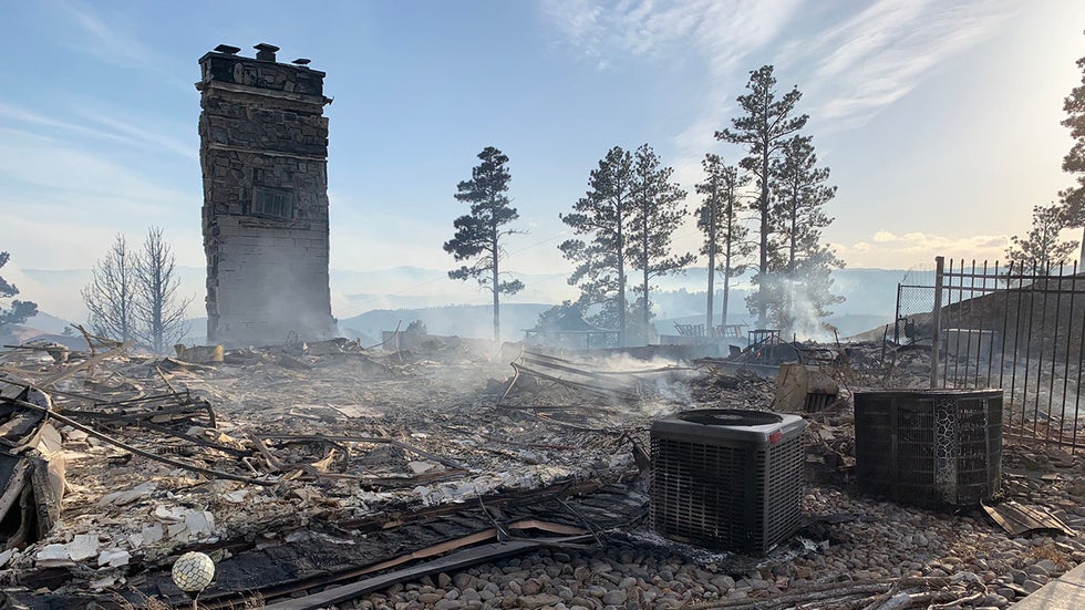
Wildfires burning in the Black Hills of South Dakota have forced hundreds of residents to evacuate and Mount Rushmore to close.

The largest, the Schroeder Road fire, has consumed nearly 3 square miles just west of Rapid City, South Dakota. It was first reported at 9:22 a.m. Monday MDT and was driven by winds that gusted over 70 mph in Rapid City.

“We are at record-dry conditions along with high winds playing a major factor in this fight,” Jay Esperance, division director for South Dakota Wildland Fire, said in a Facebook post.

The blaze has destroyed at least one home and several outbuildings, according to the Pennington County Sheriff's Office. It is 0% contained. Officials are looking into the cause of the fire.

Article imageA chimney is one of the few recognizable structures after a house burned Monday, March 29, 2021, in the Schroeder Road fire just west of Rapid City, South Dakota. As many as 500 homes were evacuated because of the fast-moving fire.

(MORE: Two Iowa State University Students Die When Crew Club Boat Capsizes)

Sheriff Kevin Thom said 400 to 500 homes were evacuated, though some residents were allowed to return home Monday night.

"On a personal level, my wife and I were evacuated as part of the fire," Thom said at a news conference. "I watched a neighbor's house go up in flames. So it touches all of us."

About 2:30 p.m. Monday, a fire near Keystone forced officials to close Mount Rushmore National Memorial. The memorial, and roads surrounding it, will be closed at least through Wednesday.

Also at the news conference, South Dakota Gov. Kristi Noem said the fire was not threatening Mount Rushmore. She said the fire, which had burned about 75 acres, appeared to be moving toward more remote areas. Another 20-acre fire was also burning near Keystone.

Noem said a rapidly growing fire between Kadoka and Murdo, about 100 miles east of Rapid City on Interstate 90, crossed the interstate and caused at least one accident, KELO reported.

Critical fire weather conditions remain on Tuesday in much of western South Dakota, though not in Rapid City itself, the National Weather Service said.

"Gusty northwest winds will continue today across the western South Dakota plains. Winds will increase this morning and continue through the afternoon at 30 to 40 mph with gusts to 55 mph," the NWS said.

The Weather Company’s primary journalistic mission is to report on breaking weather news, the environment and the importance of science to our lives. This story does not necessarily represent the position of our parent company, IBM.

The Weather Company’s primary journalistic mission is to report on breaking weather news, the environment and the importance of science to our lives. This story does not necessarily represent the position of our parent company, IBM.

Large Pileup Shuts Down Trans-Canada Highway in Alberta Amid Snowy Conditions

Ron Brackett

Published: March 29, 2021
Article image

A pileup involving 50 to 70 vehicles shut down the Trans-Canada Highway near Brooks, Alberta, Monday morning.

The westbound lanes of the highway about 125 miles east of Calgary were expected to be closed for several hours, the Canadian Broadcasting Corporation reported. As of 9:30 a.m. Mountain Daylight Time (11:30 a.m. EDT), traffic was being detoured to Highway 1A.

"Travel on area highways is not recommended at this time due to blowing snow, icy roads and poor visibility," said the Royal Canadian Mounted Police.

The RCMP also said a reception area was set up in Brooks at the Heritage Inn for people unable to get through the area because of the weather and the road conditions.

The weather has caused several accidents along Alberta's highways. A semitrailer overturned on Highway 1 near Highway 56 east of Calgary, and another overturned on Highway 2 just north of the city, according to 511alberta. The service also warned of several jackknifed semitrailers and vehicles that had spun out.

Much of eastern Alberta is under wind, snow or winter storm warnings, according to Environment Canada. The city of Brooks and surrounding Newell County could see winds over 60 mph Monday, the agency warned.

The winds are part of a strong low-pressure system tracking through Canada that is also bringing high winds and fire danger to the U.S. Great Plains states, according to weather.com meteorologist Chris Dolce.

The Weather Company’s primary journalistic mission is to report on breaking weather news, the environment and the importance of science to our lives. This story does not necessarily represent the position of our parent company, IBM.

The Weather Company’s primary journalistic mission is to report on breaking weather news, the environment and the importance of science to our lives. This story does not necessarily represent the position of our parent company, IBM.

Flooding Kills 5 in Tennessee, Forces Evacuations and Shuts Roads in Kentucky and Virginia

 Ron Brackett

Published: March 29, 2021


A storm system that left five people dead in Tennessee on Sunday also caused extensive flooding that damaged homes and businesses and closed roads in Kentucky and Virginia.

The Tennessee Highway Patrol reported a 61-year-old woman died Sunday afternoon when her Nissan Sentra was swept off a road and into flooded Big Creek in Hawkins County, according to the Kingsport Times News. The THP said Donna Adams of Surgoinsville was swept out of the rear passenger side window and was found about 20 yards from the vehicle.

The Metro Nashville Police Department said four people died in the flooding in that city. A search and rescue team recovered the body of 70-year-old Garry Cole Sunday morning from a Honda sedan submerged in flooding from a creek next to a Walmart at Harding Place and Nolensville Pike.

A second presumed flooding victim was found on the Nashboro Village golf course. Police think Douglas Hammond, 65, was swept away by high water after getting out of a car that ran off the road into a culvert.

(WATCH: Dynamic End to March; Here's What You Need To Know)

Two additional flooding victims, a man, 64, and a woman, 46, were found dead close to a homeless camp near the Wentworth-Caldwell Park, the police department reported. They have not yet been identified.

Nashville Mayor John Cooper declared a state of emergency in the city because of the flooding.

More than 130 people had to be rescued from the flooding in the city. Some residents of the Glencliff neighborhood climbed into their attics as the floodwaters rose, The Tennessean reported. Rescuers had to save 15 people from an apartment complex after they were trapped by a mudslide and high water.

Outside of Nashville, flooding hit Mt. Juliet, Lebanon, Brentwood and parts of Franklin.

In Williamson County, the rising Harpeth River trapped a family of eight in their home. Rescue crews made two trips with rafts to rescue everyone, WKRN reported. The Williamson County Emergency Management Agency said crews responded to 34 water rescue calls.

The Harpeth River is expected to reach 35 feet by Monday afternoon, WKRN reported. The record is 35 feet and 3 inches.

More than 20 people were evacuated from their homes across Campbell County, WATE reported.

In Kingsport, Tennessee, the Fire Department's swift water rescue team evacuated four families from flooded apartments, WJHL reported.

The flooding destroyed a piece of history in Scott County. Half of the 110-year-old Burnt Mill Bridge near Allardt, Tennessee, washed away, WATE reported.

Debris from the old truss bridge, which had been closed to cars since 2003, slammed into the new bridge, meaning Honey Creek Road is closed until state engineers can inspect the damage, according to the Independent Herald.

The Big South Fork River crested at 20.61 feet at Burnt Mill at 11 a.m. Sunday — the second-highest crest since a flood in 1929 that caused catastrophic damage in Scott County, the Independent Herald reported.

Kentucky

Floodwaters flowed through the streets of Middlesboro, Kentucky, for the second time in a little more than a year on Sunday.

"I want to encourage everyone to please stay home! The water is rising fast in Middlesboro blocking several roads," the city said in a Facebook post shortly after 7 a.m. Sunday. "The flooding appears to be worse than it was in 2020."

The water rose as high as the windows on businesses along Cumberland Avenue, WBIR reported. That road and Highway 25E had to shut down because of the flooding.

(WATCH: Massive Lightning Strike Hits Transformer, Blows Out Power)

Middlesboro Fire Chief Robert England said some residents had to be rescued from their homes when water quickly rose toward them.

Middlesboro also flooded in early February 2020 after torrential rain left the water as high as 5 feet in some places, according to WBIR.

“About once a year we seem to have a flood and it affects a pretty big part of the city and kind of shuts us down,” Mayor Rick Nelson told WBIR.

About 50 miles to the northeast, Hazard, Kentucky, also flooded Sunday. Police diverted traffic in at least six locations.

The flooding also covered roads and bridges in Clay and Leslie counties, according to WYMT. Floodwaters almost reached the net on a basketball goal in River Front Park in downtown Hyden, WYMT reported.

The Kentucky Transportation Cabinet said the flooding shut down roads in Bell, Harlan, Knox and Whitley counties. More than 30 closures remained Monday morning.

Virginia

Flooding also shut down roads in Abingdon on Sunday afternoon, WJHL reported.

U.S. Highway 421 was closed in Lee County between Woodway and Pennington Gap, the Lee County Sheriff's Department said.

New Jersey

The storm system brought high winds with gusts up to 60 and 70 mph to parts of New Jersey on Sunday.

The strong winds ripped sections of roof off the Neptune Motor Lodge in Neptune, New Jersey, and scattered debris across Route 35, according to the Asbury Park Press.

"The storm came through pretty quickly, caused damage primarily to this building and some power lines down, some poles snapped, a lot of debris in the roadways," Michael Bascom, emergency management coordinator in Neptune Township, said. "One minor car crash was a result of the debris in the roadway."

The National Weather Service will investigate the damage to determine if it came from a tornado or straight-line winds.

The NWS said it had received several wind damage reports mainly along the Interstate 95 corridor.

The storms also caused roof damage and trees to fall on structures in Mercer, Ocean and Union counties, nj.com reported. Police in West Windsor closed sections of Route 571 and Clarksville Road because of downed trees and utility poles.

About 27,000 customers were without electricity in New Jersey at about 9 p.m., according to nj.com.

The Weather Company’s primary journalistic mission is to report on breaking weather news, the environment and the importance of science to our lives. This story does not necessarily represent the position of our parent company, IBM.

The Weather Company’s primary journalistic mission is to report on breaking weather news, the environment and the importance of science to our lives. This story does not necessarily represent the position of our parent company, IBM.

AccuWeather's 2021 Atlantic hurricane season forecast

 By Kevin Byrne, AccuWeather staff writer

Updated Mar. 31, 2021 1:34 PM EDT


Although spring is just in its infancy, a group of AccuWeather meteorologists has been focusing on a different time of year: hurricane season. And based on current weather data as well as long-range climate clues, the forecasters are urging residents in traditional hurricane-prone areas of the United States to make their preparations now.

So what does the 2021 season have in store? According to AccuWeather forecasters, another busy year is in the cards, albeit one that will turn out a bit less hectic than 2020’s nonstop season.  

The 2020 Atlantic hurricane season was like no other. Not only did it produce 30 named storms, the most on record, but the United States suffered 12 direct strikes, smashing the previous record of nine from 1916. Forecasters had to turn to the rarely used Greek alphabet for only the second time in history to name tropical systems.

AccuWeather’s team of tropical weather experts, led by veteran meteorologist Dan Kottlowski, predicts that the 2021 Atlantic hurricane season will result in 16-20 named storms, including seven to 10 hurricanes. Of the storms projected to reach hurricane strength, three to five are predicted to become major hurricanes (Category 3 or higher storms that have maximum sustained winds of 111 mph or greater).

New research published earlier this year from University of Miami researcher Brian McNoldy found that there is a new normal for named tropical systems in the Atlantic based on a 30-year average from 1991 to 2020.

AccuWeather’s forecast, when compared to that 30-year average, indicates that 2021 is expected to be an above-normal season for tropical activity in the Atlantic. A normal season is considered to have 14 storms, seven hurricanes and three major hurricanes. Last year, 13 hurricanes formed, and six of those reached the major hurricane threshold.

In terms of the number of storms that will directly impact the mainland U.S., Puerto Rico and the U.S. Virgin Islands, three to five are expected, according to Kottlowski's team. The annual average number of direct impacts is 3.5.

“Current indications are this will be another above-normal season,” said Kottlowski, who is in his 45th year of issuing forecasts for AccuWeather. “This can translate into high impacts on the United States.”

To come up with the forecast, Kottlowski and his team examined current weather patterns then studied long-range climate models to make a determination about what will happen during the heart of the season in August, September and early October. There are several key factors that will influence the upcoming season.

La Niña or no La Niña? That is the question

One of the determinants for how the season will shape up is the El Niño Southern Oscillation (ENSO). ENSO is defined simply as a short-term climate fluctuation that is determined by warming or cooling of the waters in the central and eastern Pacific Ocean. When the water in the equatorial Pacific is warmer than average, an El Niño is typically declared. When the reverse is true, it’s known as a La Niña.

Current forecasts are calling for the existing La Niña pattern to shift to an ENSO-neutral phase by the late spring or early summer which means water temperatures in this zone of the Pacific will be closer to average.

The big question at this time is whether or not the pattern shifts back to a La Niña by the latter part of the hurricane season, according to Kottlowski.

“If that happens, that could certainly increase the chance that we could see more than 20 storms,” he said.

This GOES-16 GeoColor satellite image taken Wednesday, Aug. 26, 2020, at 2:40 p.m. EDT., and provided by NOAA, shows Hurricane Laura over the Gulf of Mexico. (NOAA via AP)

But what does the water temperature in part of the Pacific have to do with the Atlantic hurricane season?

During La Niña patterns, wind shear becomes less prevalent in the atmosphere over the Atlantic. Vertical wind shear is one of the biggest inhibitors of development for tropical systems. When there is less wind shear in the atmosphere, storms can develop with less obstruction. La Niña conditions were present during the height of 2020’s prolific season.

If La Niña returns and more than 21 tropical storms develop, there could be a new first for the Atlantic. Previously, if 22 named storms formed in one season, which only happened in two hyperactive years -- 2005 and 2020 -- Greek letters were used to name tropical cyclones. The World Meteorological Organization announced in March that a supplemental name list will now be used once the designated list is exhausted.

Water temperatures in the Atlantic are already above normal

Troubling signs are already emerging in the western Atlantic. According to Kottlowski, sea-surface temperatures (SSTs) are above normal in the northern and central Gulf of Mexico. Waters in much of the Caribbean and tropical Atlantic are also warmer than normal or around normal.

As of March 29, water temperatures off Key West, Florida, were around 81.5 degrees Fahrenheit, which is about five degrees above normal. Yet, that remains a far cry from March 29, 2020, when the water temperature was 87.8 degrees in the area.

This map shows where ocean temperatures are above normal (yellow to red) or below normal (blue to purple) in degrees Celsius. Water temperatures across much of the Atlantic basin are above normal for late March, particularly in the Gulf of Mexico where temperatures ranged from the mid-70s F to low-80s F. (NOAA)

The one exception is the western Gulf of Mexico, where water temperatures at the end of March were cooler than normal due to the historic Arctic outbreak across the South in February. However, those water temperatures are expected to increase by the time the season begins.

The official start date to the Atlantic season is June 1, but in recent years, named storms have become common in May and even as early as April. Kottlowski said that based on current trends and the warm waters in the primary tropical breeding grounds of the Atlantic, he expects a “higher-than-normal” chance of a preseason storm to develop this year.

“Our biggest concern is the fact that water temperatures across the Atlantic are already warmer than normal over a larger part of the basin,” Kottlowski said, adding that it won’t take much to make those water temperatures go even higher through the summer and into the peak of the season.

SSTs were above normal for the entirety of the 2020 tropical season.

Since 2010, seven Atlantic hurricane seasons have had at least one storm form before the June 1 start date. The last season without any preseason tropical development was 2014.

Because of this trend of frequent preseason storms, the National Hurricane Center is considering moving the official start date to May 15 in future years.  

Studying the past to predict the future

The high end of AccuWeather’s forecast for direct strikes on the U.S. is five this year. In 2020, five landfalling storms struck Louisiana alone. In fact, southwestern Louisiana was the site of nearly identical landfalls from Category 4 Hurricane Laura in August and Category 2 Hurricane Delta in October.

The Gulf Coast was a frequent target last year, with a barrage of storms unloading on areas from southern Texas to northern Florida. One of the reasons storms kept churning into the Gulf of Mexico was the strength and position of the Bermuda high. This high-pressure area was strong last year and helped force more storms away from the Eastern Seaboard and into the Caribbean and the Gulf of Mexico.

This season, AccuWeather meteorologists believe the Bermuda high will not maintain its strength as frequently as it did in 2020 and they don’t expect it to dig as far south into the Gulf of Mexico and Caribbean. This will promote a greater chance of storms to recurve through the western Atlantic and toward the Eastern Seaboard, according to Kottlowski.

Recurving storms in the Atlantic have a greater chance of impacting the East Coast, whether through higher-than-normal surf or landfalls along the coastline, he explained.

Analog years serve as another data point to reference when piecing together a forecast for an entire hurricane season. Analog years are past years that have weather similar to current and projected weather patterns. Forecasters will often use analog years as a way to determine future trends and predict which parts of the United States could have a high risk.

Several past hurricane seasons that the forecasters studied when generating this forecast were 1996, 2001 and 2012. Based on climate data from those years and similar seasons, the areas at greatest risk for direct impacts from hurricanes or tropical storms are the western and northern Gulf of Mexico, all of Florida and along the North Carolina coast, AccuWeather meteorologists say. Superstorm Sandy caused billions of dollars in damage and killed more than 145 when it slammed into the East Coast in late October of 2012.

Keeping a close eye on Africa

Hurricanes often form in the far eastern Atlantic after tropical waves that float across Africa emerge over the open waters of the Atlantic and quickly strengthen into more robust storms. A normal to above-normal number of tropical waves is predicted to develop off the African coast this season, due to a weather influencer known as the African easterly jet, which consists of strong low to mid-level winds in the atmosphere over central Africa.

Development is often hindered earlier in tropical seasons due to the presence of dry air and dust that makes their way over the open Atlantic from the Sahara Desert. That is expected to be the case in 2021 as well, Kottlowski said. However, by the peak of the season, the dry air and dust will become less common, which should allow for more tropical development.

How intense could this season be?

Accumulated Cyclone Energy (or ACE) is a metric meteorologists use to determine how intense the year is for a particular tropical basin. Although 2020 was busier than any other season on record, it wasn’t the most intense hurricane season. It produced an ACE value of 182, which is less than the 2017 season’s total of 225 and the whopping 245 from the 2005 season, according to records kept by Colorado State University researchers.

For 2021, AccuWeather forecasters expect a slightly above-normal season when it comes to intensity. An ACE value of 120-160 is predicted; the 30-year average for Atlantic seasons is 123.

ACE doesn’t necessarily tell the whole story, Kottlowski cautioned. Just because a season has a lower ACE value than another, that doesn’t necessarily mean storms will be less damaging to the United States.

'The time is now for you to plan'

While there are still two months to go until the official start of the Atlantic hurricane season, Kottlowski says now is the time for residents of hurricane-prone regions to formulate a hurricane safety plan and study up on evacuation routes and nearby shelters.  

Chris Nagiewicz, left, watches as his wife Mary screws in a hurricane panel, Saturday, Aug. 1, 2020, on a trailer home in Briny Breezes, Fla., ahead of Hurricane Isaias. (AP Photo/Wilfredo Lee)

It doesn’t take a major hurricane to cause life-altering damage to a person’s property. Even a slow-moving tropical storm has the potential to dump feet of rain and trigger life-threatening flooding.

The season doesn't officially end until Nov. 30 and 2020 is a good reminder of that. Hurricanes Delta and Zeta both struck the Lousiana coast last October. However, tropical activity persisted all the way into mid-November last season, as Central America was struck by two major hurricanes, Eta and Iota, within the span of two weeks.

“Please educate yourself now,” Kottlowski said when asked what message was important to convey to people living in hurricane-prone locations.

“Another issue that we will face still is the COVID-19 pandemic," he said. "This is still going to cause major concerns for evacuation centers. Don’t wait until August or September, during the heart of the hurricane season, to figure out what you’re going to do. The time is now for you to plan.”

RELATED:

Keep checking back on AccuWeather.com and stay tuned to the AccuWeather Network on DirecTV, Frontier, Spectrum, FuboTV, Philo, and Verizon Fios.
Man missing at sea for nearly 2 weeks found alive in life raft off Washington coast

  One of two men missing at sea for nearly two weeks was found alive on Thursday by a Canadian fishing boat in a life raft in Canadian water...