Chris Dolce
Twin tornado scars can be seen from space in new satellite images over Alabama following last Thursday's destructive severe weather outbreak in the state.
Intense tornadoes that remain on the ground for a long distance have a higher chance of producing a damage path that's visible on satellite. That is particularly true in regions of the country where dense forests exist, like the Southeast.
That's exactly what happened on March 25 to the south of Tuscaloosa, Alabama, when a pair of intense tornadoes carved their way through areas near and in Talladega Forest. You can see these scars in the comparison of images from the European Space Agency's Sentinel 3 satellite before (March 22) and after (March 29) the tornadoes struck.
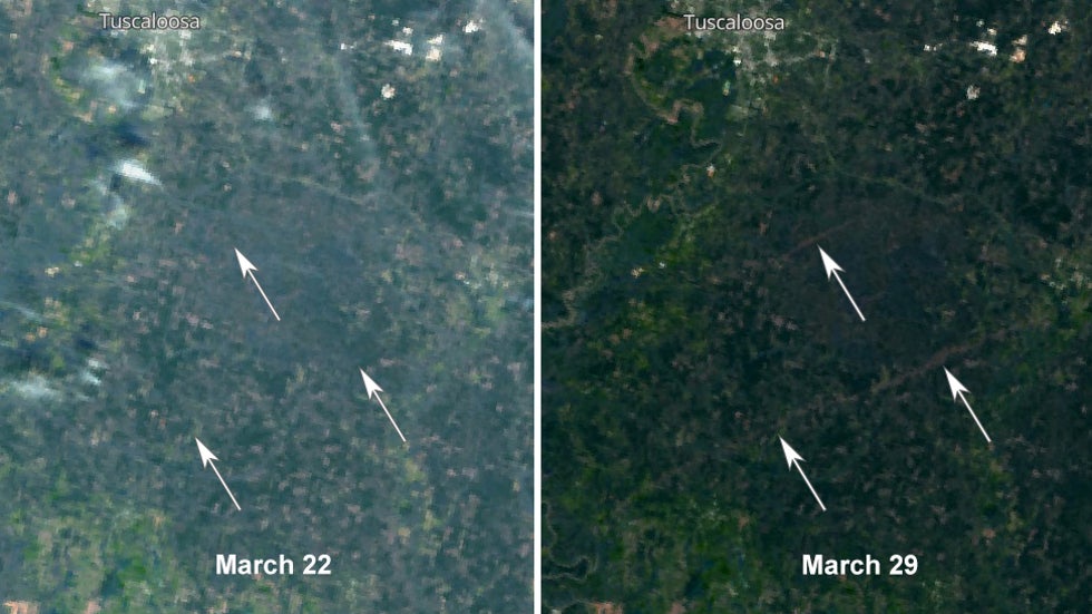 Left image shows the area on satellite before the tornadoes on March 22. The right image shows the two tornado scars (narrow brown shaded areas) on satellite on March 29.
The bottom two arrows show a portion of the scar from a tornado that was on the ground for an incredible 80 miles, from Hale County to Shelby County. It's estimated the twister lasted 98 minutes and was up to 1.3 miles wide.
In its post-storm survey, the NWS said, "Tens and tens of thousands of trees were snapped or uprooted. The volume and extent of snapped trees was incredible, pushing the rating to EF3." This tree destruction is the narrow brown shading you see through the forest in the after image from March 29.
Camping & Tactical Gear on Sale Now (SPONSORED)
You can see another smaller tornado scar highlighted by the top arrow. That twister also had a maximum rating of EF3, but lasted a much shorter distance of about 11 miles as it traveled from Hale County to Tuscaloosa County.
The tweet below from the National Weather Service in Birmingham shows the tracks of this pair of tornadoes as well as multiple others from March 25.
You can see the full track of the bottom tornado scar labeled as Sawyerville to Centreville to Columbiana. The top tornado scar is labeled as Elliots Creek.
There've been numerous examples of tornado scars appearing on satellite in recent years, including one last April in Mississippi.
One of the most notable examples is a tornado that struck northern Wisconsin more than a decade ago. Its path is still easy to spot, particularly in winter, when there is a contrast between snow on the ground and the surrounding forest that remains.
The Weather Company’s primary journalistic mission is to report on breaking weather news, the environment and the importance of science to our lives. This story does not necessarily represent the position of our parent company, IBM.
The Weather Company’s primary journalistic mission is to report on breaking weather news, the environment and the importance of science to our lives. This story does not necessarily represent the position of our parent company, IBM.


No comments:
Post a Comment