Jonathan Belles
Tropical Storm Philippe has formed in the middle of the tropical Atlantic and will remain far away from land for the next few days.
The system is several hundred miles west of the Cabo Verde Islands and is traveling westward across the tropical Atlantic Ocean.
It has gradually developed a circulation since departing the west coast of Africa and should have generally favorable atmospheric conditions in the Main Development Region (MDR).
It will follow the southern edge of the Bermuda High over the next few days, typically moving west or west-northwest heading into the middle of the next week. This part of the forecast is fairly certain.
(OTHER TROPICAL TROUBLE: Wet, Windy Weekend Expected in the East)
Another wide turn ahead? As we saw with Hurricane Lee, the next step in this system’s voyage will likely be a northward turn, but where and when this turn takes place is somewhat uncertain.
This turn will depend on when the Bermuda High will let its guard down. That ridge deflects systems westward in its clockwise flow until storms either outrun the dome of high pressure or the high pressure system weakens or moves away.
It is increasingly likely that this turn will occur to the east and north of the Leeward Antilles, but some impacts to the islands are still possible. What, if any, impacts may be are uncertain, but increased surf along north and east-facing shores is an increasing concern.
The NOAA Hurricane Hunters may send out a jet to investigate the pattern in the Atlantic as soon as Monday, which should help computer forecast models narrow those uncertainties.
Those in the Leeward and Virgin islands and Puerto Rico should keep an eye on this system. Changes to the forecast are expected through next week.
(MORE: The Relationship Between Climate Change and Rainfall)
Autumn brings a new storm track: The African tropical wave train generally becomes less active as we move into late September and October, and we'll need to begin looking closer to the Caribbean, Gulf of Mexico and western Atlantic for tropical development for the remainder of the season.
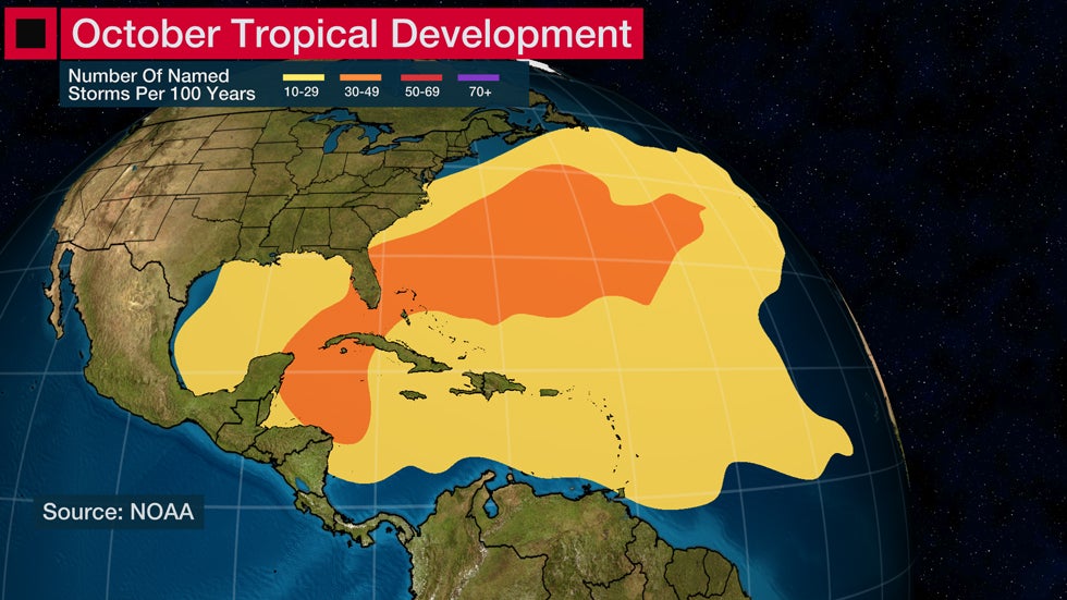 Common Development Areas for October
Hurricane season continues through the end of November and several additional tropical systems are expected over the next nine weeks.
The Weather Company’s primary journalistic mission is to report on breaking weather news, the environment and the importance of science to our lives. This story does not necessarily represent the position of our parent company, IBM.
The Weather Company’s primary journalistic mission is to report on breaking weather news, the environment and the importance of science to our lives. This story does not necessarily represent the position of our parent company, IBM.


No comments:
Post a Comment