Jonathan Erdman And Chris Dolce
Category 5 hurricanes are fairly rare in the Atlantic Basin, but almost 100 years of history shows there are locations and times of hurricane season in which they occur most often.
Lee joined this rare group when it rapidly intensified from a Category 1 to a Category 5 hurricane as it tracked through the Atlantic on Sept. 7.
Category 5 is the highest rating a hurricane can reach: Maximum sustained winds of 157 mph or higher on the Saffir-Simpson Hurricane Wind Scale are required for a hurricane to reach this intensity.
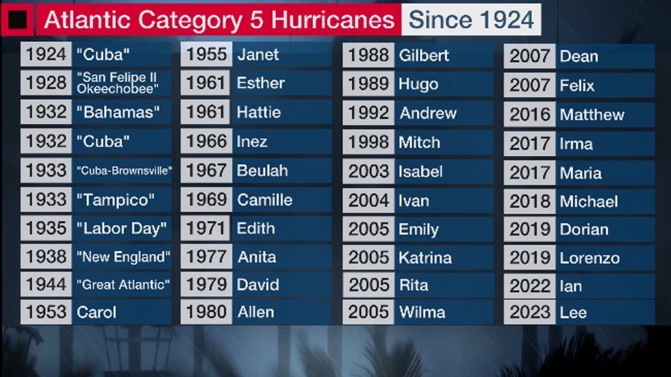
Before Lee, there had only been 39 such hurricanes in the Atlantic Basin since 1924, according to NOAA's historical database.
Ian was the most recent, prior to Lee: Maximum winds in Ian briefly hit 160 mph while it was over the Gulf of Mexico on the morning of Sept. 28, 2022. It then made landfall in Florida as a strong Category 4 with 150 mph winds just seven hours later.
There have been eight Category 5 Atlantic hurricanes since 2016: Before Lee and Ian, Dorian and Lorenzo in 2019, Michael in 2018, Maria and Irma in 2017 and Matthew in 2016 have completed this most recent spate of Category 5 Atlantic hurricanes.
That four straight year streak from 2016 though 2019 with at least one Category 5 hurricane was the most consecutive years on record.
 The list of Category 5 Atlantic Basin hurricanes from 1924 through 2023.
There have been long "droughts" as well: Prior to 2016's Hurricane Matthew, the Atlantic went eight consecutive hurricane seasons without a Category 5. There was another eight-year stretch between hurricanes Allen and Gilbert from 1980 to 1988.
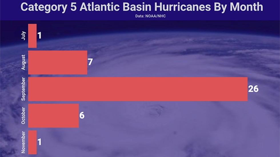
They are most common in the peak of hurricane season: September is when Category 5 hurricanes have occurred most often, by far. But they have also happened at least a half dozen times each in August and October.
This encompasses the most active period of hurricane season. That's because all of the favorable conditions and ingredients for development are most likely to overlap over a large area of the Atlantic Basin.
Hurricane Emily was the earliest Category 5 on record, doing so in the Caribbean Sea on July 16-17, 2005. The Cuba hurricane of 1932 was the latest Category 5, the only one to do so in November (Nov. 5-8).
 Category 5 Atlantic Basin hurricanes by month from 1924 through 2023. (Note: The total of the monthly tallies is slightly higher than the total hurricanes, since one hurricane was at that intensity in late Sept. and early Oct.
Here's where in the Atlantic they have most commonly formed: The map below shows locations where hurricanes have reached Category 5 intensity, including Hurricane Lee.
Other than the oddity that was 2019's Hurricane Lorenzo in the far eastern Atlantic, you'll notice almost all of them happen in the same general area, from the southwest Atlantic Ocean north of the Lesser Antilles into the Caribbean Sea and Gulf of Mexico.
These areas are so conducive to strengthening because they have a supply of deep, warm ocean water, lack hostile shearing winds in the heart of hurricane season and feature a parade of disturbances known as tropical waves, which act as seeds for development. The supply of deep, warm ocean water that serves as fuel for hurricanes is highest in the Atlantic Basin in these areas, particularly the western Caribbean Sea.
Hurricanes don't hold onto Category 5 intensity for long: On average, a hurricane maintains Category 5 status for about 24 hours.
That's because intense hurricanes typically undergo one or more eyewall replacement cycles. During one of these, the hurricane's intense ring of thunderstorms surrounding its eye is surrounded by a new outer ring.
When that happens, the hurricane's wind intensity drops temporarily as the former eyewall is choked off. It usually intensifies again when the new outer eyewall is pulled inward, leading to a larger hurricane.
Several Category 5 hurricanes reached that intensity multiple times during their lifetime.
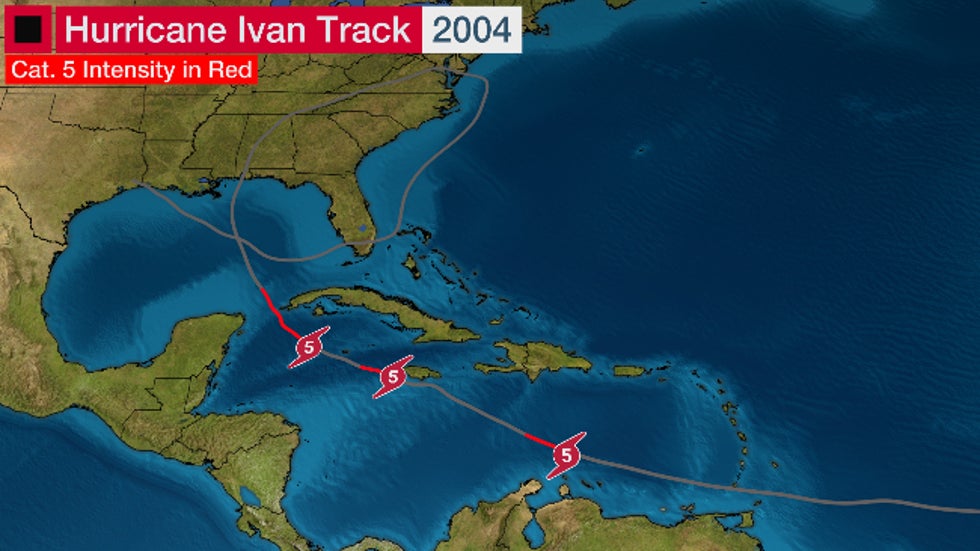
Hurricanes Allen (1980), Isabel (2003) and Ivan (2004) each soared to Category 5 intensity three separate times in their journeys.
The November 1932 Cuba hurricane (78 hours) and Hurricane Irma in 2007 (77 hours) spent the longest combined time at Category 5 strength, according to NOAA's database.
 As the map above, but here we show the three separate times Hurricane Ivan attained Category 5 intensity in early-mid September 2004.
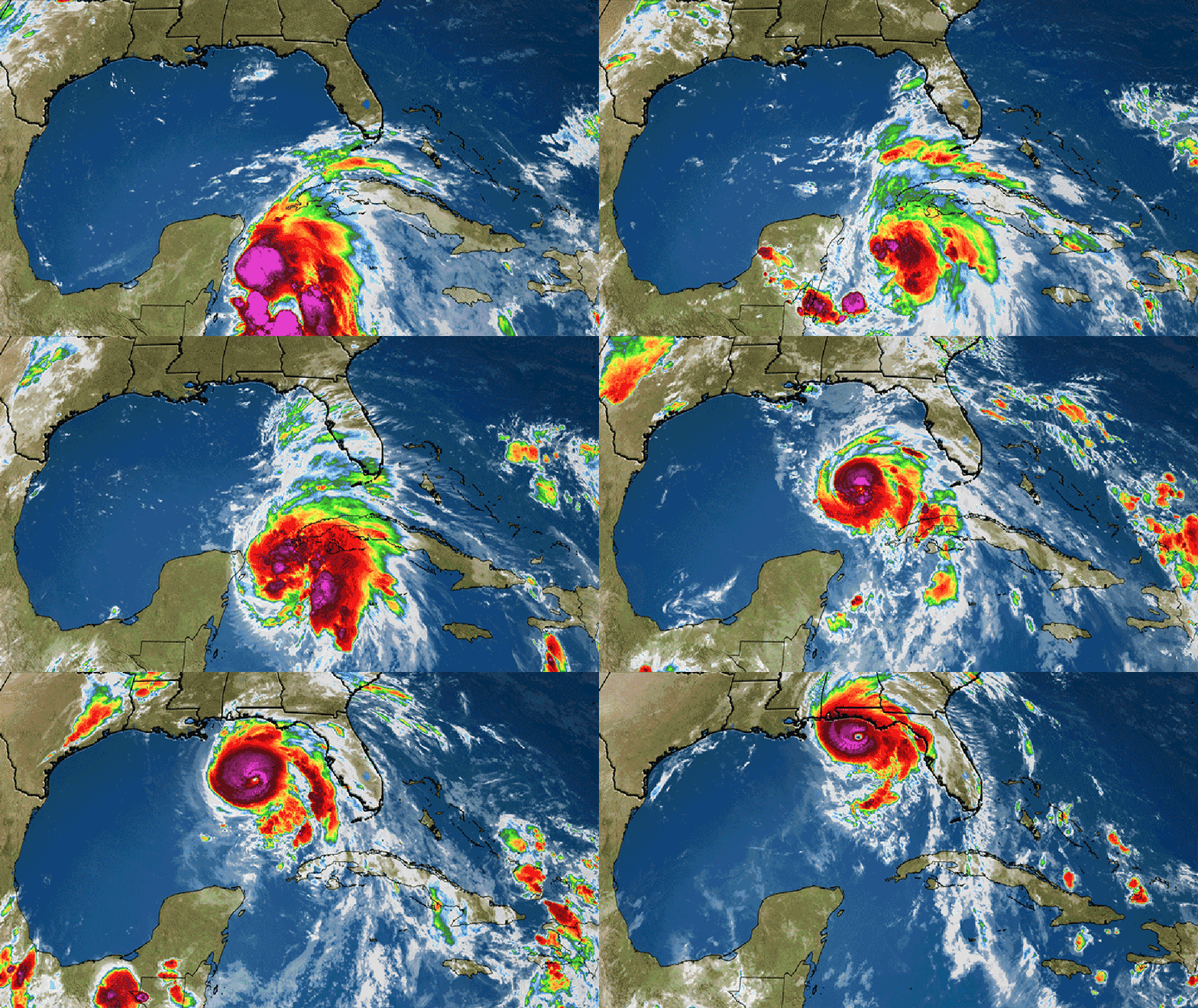
Only four hurricanes on record have made landfall in the mainland U.S. at Category 5 intensity: The most recent of these was Hurricane Michael in the Florida Panhandle in October 2018.
The others include Andrew in 1992 in South Florida, Camille in 1969 on the Mississippi Gulf Coast, and the 1935 Labor Day hurricane in the Florida Keys.
Hurricane Ian very nearly did that in 2022, but ticked down to a still intense Category 4 hurricane when it made landfall.
 Satellite loop of Hurricane Michael from when it first formed into a tropical storm to near its Category 5 landfall.
Chris Dolce has been a senior meteorologist with weather.com for over 10 years after beginning his career with The Weather Channel in the early 2000s.
Jonathan Erdman is a senior meteorologist at weather.com and has been an incurable weather geek since a tornado narrowly missed his childhood home in Wisconsin at age 7. Reach out to him on X (formerly Twitter), Facebook and Threads.
The Weather Company’s primary journalistic mission is to report on breaking weather news, the environment and the importance of science to our lives. This story does not necessarily represent the position of our parent company, IBM.
The Weather Company’s primary journalistic mission is to report on breaking weather news, the environment and the importance of science to our lives. This story does not necessarily represent the position of our parent company, IBM.

No comments:
Post a Comment