weather.com meteorologists
An ice storm will continue to create dangerous travel conditions and cause some tree damage and power outages from parts of Texas to Tennessee and Kentucky through midweek.
This weather system has been named Winter Storm Mara (MARE-uh) by The Weather Channel.
(MORE: How Winter Storms Are Named)
Mara's ice threat is occurring in multiple rounds that will last through Wednesday night or early Thursday. The first wave of wintry weather spread freezing rain and sleet from central and northern Texas and central and eastern Oklahoma to Kentucky from Monday into early Tuesday.

Here's a look at what's to come.
Current Status
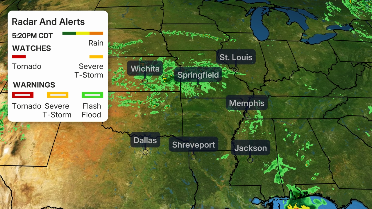
Freezing rain and sleet have been reported this morning from the lower Mississippi Valley near Memphis, Tennessee, to portions of Kentucky.
Parts of northern and central Texas, including Dallas to Austin and San Antonio, have also seen freezing rain to begin the morning. There have been multiple reports of serious accidents in the Austin metro area because of icy conditions.
 Current Conditions
An ice storm warning is in effect from central Arkansas to western Tennessee and extreme northwestern Mississippi, including Little Rock and Memphis. Icing in these areas could be heavy enough to cause tree damage and knock out power, and will make most roads hazardous.
Winter storm warnings and winter weather advisories are in effect for a broad area of Texas to portions of the Mississippi, Tennessee and Ohio valleys.
The winter storm warnings include the Dallas-Ft. Worth Metroplex, Austin, and San Antonio, which means widespread hazardous travel is expected with at least some potential for power outages and damage to trees.
Locations in winter weather advisories like Nashville, Tennessee, and Oklahoma City, could see disruptions to daily life, including slippery travel.

Ice Forecast
There is a high chance of ice accumulating at least 0.10 inch thick through Thursday from central and northern Texas into southern Oklahoma, much of Arkansas, western Tennessee and northwest Mississippi.
Those ice accumulations could be on various surfaces like tree limbs, power lines and cars. Elevated roads and bridges will ice first in these areas, but many roads may become icy.
(MORE: What Ice Accumulations Mean)
Areas from west-central Texas to Dallas-Ft. Worth, and near the Interstate 40 corridor of central and eastern Arkansas to near Memphis, have the highest chance of more damaging ice accumulations capable of tree damage and power outages.

Forecast Timing
Through Tuesday Night
A wintry mix of freezing rain and sleet will stretch from central and northern Texas and parts of Oklahoma to much of Arkansas, the western half of Tennessee, northwest Mississippi, southern Kentucky and West Virginia.
Austin and Dallas, Texas, Little Rock, Arkansas, and Memphis and Nashville, Tennessee, are some of the cities that could see periods of freezing rain and/or sleet.
 Tuesday's Forecast
Wednesday
The stagnant weather pattern will hold in place Wednesday and Wednesday night.
That means icy travel will continue to be possible from western, central and northern Texas eastward into Arkansas and the lower Mississippi Valley.
Some patchy lingering freezing rain is still possible early Thursday in some of these areas before precipitation begins to be pushed farther south into above-freezing air.
Residents in these areas need to plan for the potential of power outages that could last at least several hours. You also need to consider postponing or canceling travel in these areas until the storm is over.
 Wednesday's Forecast
Monday's Recap
Up to an inch of sleet was reported Monday in parts of eastern Oklahoma, including the Tulsa metro area, accompanied by lightning, at times. About a half inch of sleet was reported in Denton, Texas.
Portions of the Dallas-Fort Worth metroplex saw a mix of freezing rain and sleet.
Freezing rain was reported in Fayetteville and Fort Smith, Arkansas, as well as Joplin and Springfield, Missouri. Sleet and freezing rain was observed as far south as the Texas Hill Country, including the Austin and San Antonio metros.
The Weather Company’s primary journalistic mission is to report on breaking weather news, the environment and the importance of science to our lives. This story does not necessarily represent the position of our parent company, IBM.
The Weather Company’s primary journalistic mission is to report on breaking weather news, the environment and the importance of science to our lives. This story does not necessarily represent the position of our parent company, IBM.


No comments:
Post a Comment