Jonathan Belles and Jonathan Erdman
Sign up for the Morning Brief email newsletter to get weekday updates from The Weather Channel and our meteorologists.
The 2022 Atlantic hurricane season produced a number of damaging hurricanes, particularly for the Florida Peninsula, despite its more muted statistics compared to recent years.
November 30 marks the official end of the six-month Atlantic hurricane season.
The season produced 14 named storms, eight of which became hurricanes and two of which reached at least Category 3 status.
None of those figures stand out, especially considering the entire hurricane name list was used up in 2021, and 2020 had more than double the storms of 2022, smashing a record for any season.
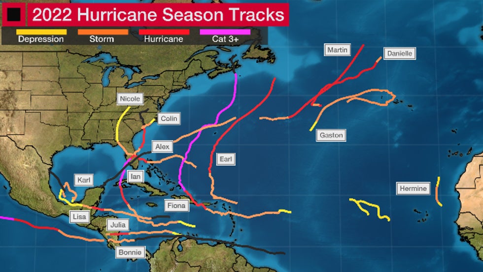
 Named storm tracks in the 2022 Atlantic hurricane season. The black segments denote either a remnant or the stage prior to a storm forming. (Note, two tropical depressions, "Eleven" and "Twelve" are also shown as yellow tracks in the eastern Atlantic Ocean. Potential Tropical Cyclone Four is also shown as a black track in the western Gulf of Mexico. None of these count in the number of storms in a season.)
But what 2022 may have lacked somewhat in quantity it far exceeded in impact.
Florida Peninsula's Recent Luck Ended
Prior to late September, the Florida Peninsula had gone five years since its last hurricane landfall, while the Panhandle had absorbed several strong hurricanes, including Category 5 Hurricane Michael.
In 2022, that lucky streak came to a screeching halt in the Peninsula.
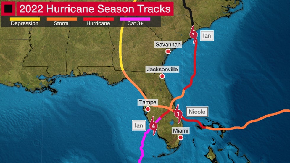
 Tracks of Hurricane Ian and Hurricane Fiona over Florida and the Southeast in 2022.
The first of Florida's two hurricanes this season arrived in late September.
Hurricane Ian made landfall near Costa Cayo, Florida, or near Cape Coral at Category 4 intensity on September 28. In a bizarre coincidence, that happened to be the exact same landfall location as Category 4 Hurricane Charley in 2004.
Ian inundated many Southwest Florida communities, including Fort Myers Beach and Sanibel Island, with more than 6 feet of storm surge. In Fort Myers, storm surge of at least 7 feet inundated normally dry ground, which shattered a record that had stood at nearly half of that.
Winds gusted over 100 mph across Southwest Florida for hours. Ian’s highest recorded wind gust was 140 mph in Cape Coral.
After landfall, Ian continued its widespread wrath of wind and water across Central Florida in a track nearly identical to Hurricane Charley’s track 18 years earlier.
Ian dropped more than a foot of rain from Florida’s Gulf Coast to its Space Coast. This caused many Central and Northeast Florida rivers to overflow their banks and remain elevated for weeks, including the Peace and St. Johns Rivers. It also triggered widespread flooding in the Orlando metro area.
Ian, responsible for at least a $50 billion damage toll, will be known as the deadliest storm in Florida in nearly 90 years.
Most of the 150+ deaths recorded were from high water. Dozens of people drowned in the hurricane’s storm surge and heavy rainfall.
Just over a month later, Nicole transitioned from a typical late-season subtropical storm into a not-so-typical November hurricane, which then made the latest November mainland U.S. hurricane landfall since 1985.
In another case of deja vu with the 2004 season, Nicole made landfall near Vero Beach and took a similar path to 2004's Hurricane Jeanne (and Frances), although Nicole was considerably weaker.
Hurricane Nicole and a strong flow of northeast winds off the Atlantic Ocean produced massive beach erosion on Florida’s Space Coast and caused numerous beachside condos and some homes to dangle on several-foot-high cliffs looking over the Atlantic. Coastal roads, parking garages and some homes crumbled into the sea.
Coastal water levels rose several feet from northeast Florida to coastal Georgia as the strong northeast winds pushed the Atlantic Ocean ashore. Inland, this second hurricane caused rivers already elevated by Ian to rise once again.
Fiona's Double Whammy
Before Ian's siege on Florida and the Southeast, Hurricane Fiona flooded parts of the Caribbean before a historic strike in Atlantic Canada.
After triggering flooding in the Lesser Antilles, up to 32 inches of rain led to widespread flash flooding, mudslides and even some homes washed away from central and southern Puerto Rico into the Dominican Republic as Fiona dragged through. The flooding was worsened by ground already soaked by rain along the southern edge of Hurricane Earl, which passed northeast of the area two weeks prior to Fiona.
Fiona's winds damaged crops and downed trees in Puerto Rico. Power was also knocked out to the entire island.
(FULL RECAP: Hurricane Fiona)
Fiona then intensified as it pushed through the Turks and Caicos, eventually becoming a Category 4 hurricane.
Despite transitioning to a non-tropical cyclone, Fiona's size only grew larger as it slammed into eastern Nova Scotia early on September 24 as Canada's all-time strongest storm as measured by pressure.
Storm surge flooding heavily damaged or swept away some homes and buildings near the coasts of eastern Nova Scotia and western Newfoundland. Water levels rose to a record 9 feet at Port aux Basques, on Newfoundland's southwestern tip, topping a record from 2017, according to The Weather Network.
Wind gusts up to 111 mph damaged homes and uprooted trees, leaving some forested areas unrecognizable, including in Prince Edward Island National Park. The Insurance Bureau of Canada estimated Fiona was Atlantic Canada's costliest extreme weather event, with an estimated $660 million in insured damage.
The Season's Mixed Signals
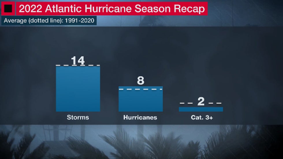
We mentioned earlier that the number of storms (14), hurricanes (8) and Category 3 or stronger hurricanes (2) wasn't anything notable. In fact, it almost matched an average season over the past 30 years of 14 storms, 7 hurricanes and 3 Cat. 3 or stronger hurricanes.
 Number of storms, hurricanes and Category 3 or stronger hurricanes in the 2022 Atlantic hurricane season. The dashed lines show the averages from 1991 through 2020 of 14 storms, 7 hurricanes and 3 Category 3 or stronger hurricanes.
But by another metric, 2022 was markedly below average.
Using the ACE (Accumulated Cyclone Energy) index, which sums up not just how many storms, but also their intensity and how long they last, the 2022 hurricane season's ACE index was about 22% below average, according to data compiled by Phil Klotzbach, tropical scientist at Colorado State University. It was the lowest ACE of any hurricane season since 2015.
One reason for this was hurricane season was shut out during one of its typically busy months.
For the first time in 25 years and only the third time since 1950, no storms formed in the Atlantic Basin in August. It was the least active hurricane season through the end of August since 1988, as measured by the ACE index.
This was particularly surprising because a La Niña was in place, which typically acts to suppress wind shear normally hostile to tropical development. Instead, August had a surplus of both wind shear and dry air in the Atlantic Basin, as we explained in a previous piece.
Despite all this, 2022 reinforced a couple of key points.
First, hurricane seasons can, and often do, roar to life in August, September or October even if they start very quietly. Eleven of the 14 storms, and all eight hurricanes, happened after August 31 in 2022.
Secondly, it's not the number of storms and hurricanes that ultimately matters in a season, but where they track.
Despite an average number of hurricanes, at least two, if not three names could be retired from future hurricane name lists (Fiona, Ian, perhaps Nicole) because those hurricanes were so destructive and/or deadly.
If all three are retired, that would match the number of hurricane names retired after the 2020 hurricane season, which had over twice as many storms, five more hurricanes and four more Category 3 or stronger hurricanes.
Other Notables And Oddities
The 2022 hurricane season wasn't all about the big three hurricanes. Here are some other things that caught our eye.
It Finally Didn't Jump The Gun
A small tropical disturbance did move into the northern Gulf Coast a week before Memorial Day. But it wasn't designated a tropical storm, which snapped a seven-year streak of hurricane seasons that started with a named storm before June 1.
The First Storm Soaked South Florida...Before It Was A Storm
Up to 15 inches of rain triggered major flash flooding in the Miami-Ft. Lauderdale metro area in the first week of June from what would eventually become Tropical Storm Alex.
But it wasn't Alex until it had passed South Florida. It was Potential Tropical Cyclone One, a designation the National Hurricane Center uses to issue tropical storm watches or warnings for a system they expect to develop.
So, for South Floridians, the preview of Alex was more impactful than the movie itself.
Central America's Active Season
While the season wasn't all that active overall, that wasn't the case in Central America.
One tropical storm (Bonnie) and two hurricanes (Julia, then Lisa) moved ashore during the season. Bonnie and Julia did so in Nicaragua, while Hurricane Lisa was the first November hurricane landfall in Belize since World War II, according to Klotzbach.
Another tropical storm, Karl, hovered in the Bay of Campeche, then fizzled before it could move ashore in southern Mexico.
November To Remember
Speaking of November, did hurricane season mix its months up in 2022?
After starting the month with a rare pair of simultaneous November hurricanes - Lisa and Martin - the aforementioned Hurricane Nicole raked Florida and the parts of the Southeast coast.
That tied 2001 for the most storms to become hurricanes in any November, according to Klotzbach. It's activity we'd expect in August or September.
Lisa found a cocoon of low wind shear and deep, warm Caribbean water. Martin and Nicole sprouted enough thunderstorms over warmer than usual Atlantic water to transform into hurricanes.
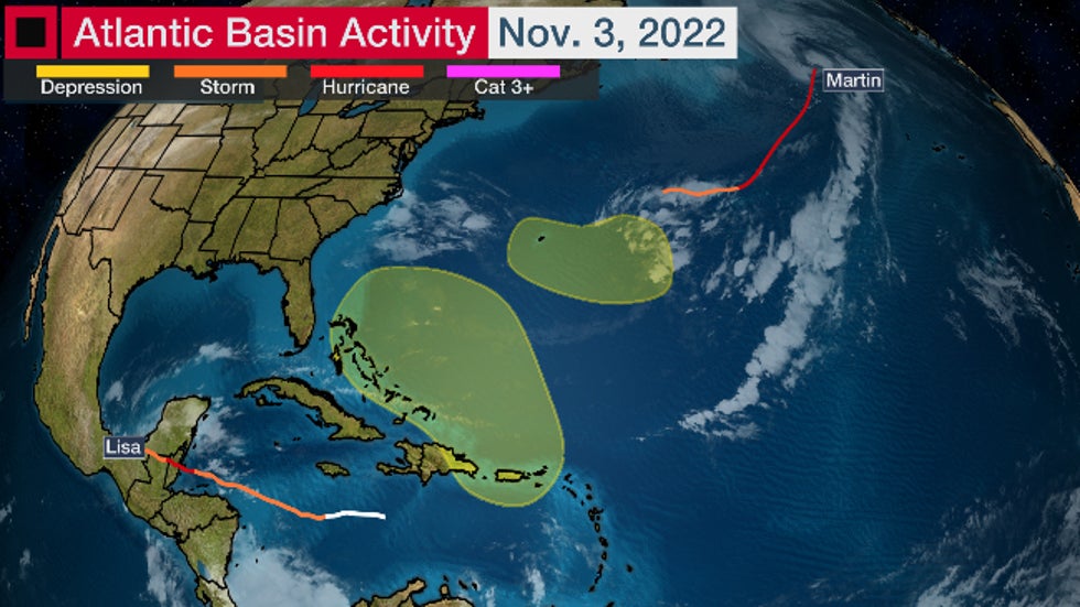
 This map showed the two areas the NHC was monitoring for possible development (in yellow), and the tracks histories of both Lisa and Martin as of Nov. 3, 2022. Nicole eventually formed within the yellow area in the Bermuda Triangle on Nov. 7.
Ian and Nicole Also Hit Georgia and the Carolinas
While these two hurricanes delivered the hardest hit on Florida, they each also had impacts in other parts of the Southeast.
Ian drove storm surge flooding into the coast of South Carolina and North Carolina before it made its final landfall near Myrtle Beach. Over 10 inches of rain fell in Charleston, South Carolina, but Ian's path farther up the coast lessened the surge, there.
As alluded to earlier, Nicole also spread coastal flooding into Georgia and South Carolina that happened over three or more high tide cycles.
Ft. Pulaski, Georgia, just west of Tybee Island, measured its sixth highest storm tide on record, resulting in an inundation of 2.91 feet above normal high tide. This lead to flooding in parts of Tybee Island, St. Simons Island and St. Marys, Georgia.
The Weather Company’s primary journalistic mission is to report on breaking weather news, the environment and the importance of science to our lives. This story does not necessarily represent the position of our parent company, IBM.
The Weather Company’s primary journalistic mission is to report on breaking weather news, the environment and the importance of science to our lives. This story does not necessarily represent the position of our parent company, IBM.

No comments:
Post a Comment