weather.com meteorologists
Winter Storm Landon is set to spread a big mess of snow, sleet and freezing rain from the Southern Rockies to the Plains, Midwest and parts of the Northeast as February begins.
(MORE: How Winter Storms Are Named)
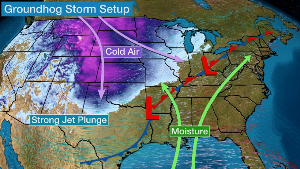
A fresh supply of arctic air will move into the nation's midsection as a sharp, southward plunge of the jet stream carves into the western and central U.S, pulling increasing moisture northward over the cold air. When this setup happens in mid-winter, it can deliver a widespread area of snow and ice that affects multiple regions over the course of several days.

Winter storm watches have now been issued by the National Weather Service along a portion of this storm's path, from Colorado to northwest Texas to Michigan. Additional winter weather alerts will likely be issued for other areas as the height of the storm draws closer.

As is almost always the case, all the key details, such as how much snow, sleet and freezing rain falls where and when, remain somewhat uncertain. But this will be a disruptive winter storm for travel by the middle of the week.
Here is our latest forecast, which will likely be adjusted as details become clearer. Check back to weather.com and The Weather Channel app for important forecast updates in the coming days.
(MORE: 6 Things to Know About Your Snow Forecast)
Forecast Timing
Tuesday night, snow, sleet and freezing rain are expected to become widespread from the Rockies into the Plains and parts of the Midwest and Great Lakes.
On Wednesday, Groundhog Day, this wintry mess will persist in many of these same areas, with the potential for heavy snow in spots. This snow, sleet and ice could extend as far south as Oklahoma and even parts of northern Texas.
Eventually, this mess will spread into the Northeast later Wednesday, but snow, sleet and ice may be confined to parts of the interior Northeast and northern New England as warmer air pumping in on southerly winds may change precipitation to rain in southern New England and the mid-Atlantic, including areas affected by Winter Storm Kenan this past weekend.
 Wednesday's Forecast
On Thursday, snow, sleet and freezing rain may persist as far south as Central Texas, extending into the Ohio Valley and Great Lakes as rain soaks much of the Northeast with the exception of upstate New York and northern New England.
As the cold front finally sweeps through, this Northeast rain may change to a bout of snow and ice as far east as southern New England and the New York tri-state area. Much of the precipitation from the storm should be winding down on Friday night.
 Thursday's Forecast
Snow, Ice Forecast
Snow
Many areas could pick up snow totals of 6 inches or more along the path of Landon, from the Southern Rockies and Central Plains into the Midwest and northern New England, including Kansas City, St. Louis, Chicago (especially southside), Indianapolis, Cleveland, Detroit, Buffalo and Burlington, Vermont. Some locations could see up to a foot or more of snowfall.
At least some light snow accumulations are possible as far south as parts of Texas.
 Snowfall Forecast
Ice
Freezing rain could accumulate on tree branches, power lines and other surfaces from portions of Texas and Oklahoma into the Ozarks and mid-Mississippi and Ohio Valleys.
In some areas, there could be enough ice to break tree branches and knock out power. Right now, that potential is highest from the Ozarks into the mid-Mississippi Valley.

To compound all this, the fresh cold air sweeping in during and behind the storm could leave roads treacherous after the storm is over, given forecast lows into at least the teens into parts of north Texas and the single digits or colder in the central Plains and Midwest.
If you have travel plans in these areas from mid- to late week, be prepared to postpone or cancel them.
The Weather Company’s primary journalistic mission is to report on breaking weather news, the environment and the importance of science to our lives. This story does not necessarily represent the position of our parent company, IBM.
The Weather Company’s primary journalistic mission is to report on breaking weather news, the environment and the importance of science to our lives. This story does not necessarily represent the position of our parent company, IBM.

No comments:
Post a Comment