weather.com meteorologists
Winter could have a cold start for many but conditions should become milder for most, according to the latest outlook from The Weather Company, an IBM Business.
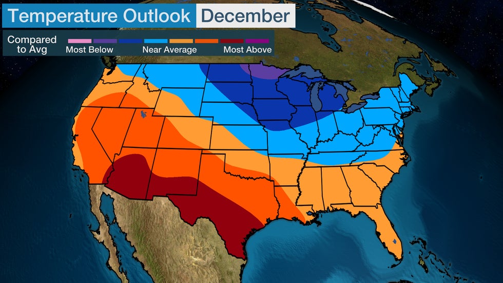
A colder shift will likely emerge from the Northeast into the Midwest and into northern Washington in December. The Northern Plains and parts of the upper Midwest, especially northern Minnesota and northeast North Dakota, will experience December temperatures the farthest below average.
Warmer-than-average temperatures are anticipated from parts of Oregon and Idaho into Texas and Louisiana, with the most anomalous December warmth from Arizona into southern Texas.

Winter Outlook
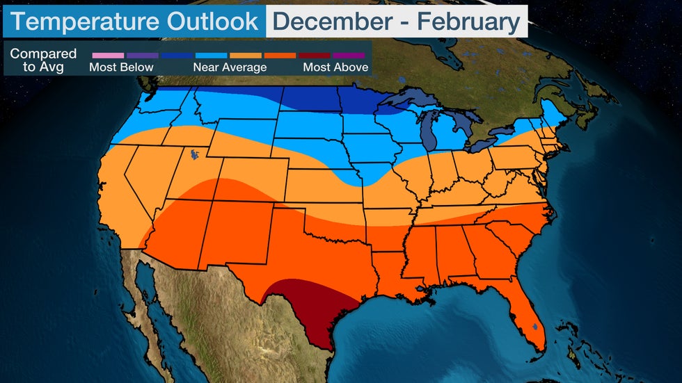
Near-average to slightly warmer temperatures are expected across the majority of the Lower 48 from New England to California for the winter season through February.
South Texas has the highest probability of above-average temperatures this winter. The Southeast, Southern Plains and Southwest will also find temperatures slightly warmer.
Areas from the Pacific Northwest into the Northern Plains and upper Midwest are the only parts of the Lower 48 that will likely see a colder than usual winter. Near-average or slightly colder temperatures are expected across parts of New England into the Central Plains and Pacific Northwest.

Let's break down the rest of the winter, month by month.
January
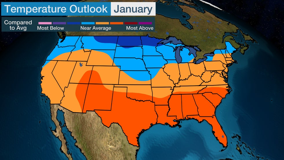
In January, temperatures will be slightly above average across most of the southern tier, with the most above-average temperatures stretching from the Four Corners to the Carolinas.
Areas from northeastern Montana into North Dakota and northern Wisconsin are expected to experience temperatures the farthest below average during what is usually the coldest month of the year.

February
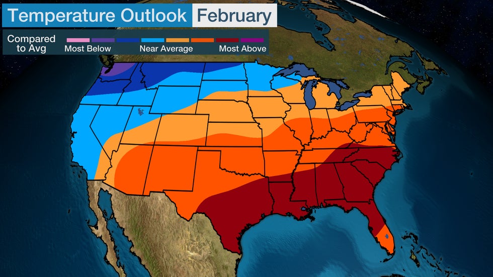
Most of the U.S. could experience warmer-than-average temperatures in February, and temperatures will be the farthest above average from Texas into much of Florida and northward into southern Virginia.
Near-average or cooler temperatures are anticipated from the West Coast into the northern Great Lakes. Temperatures will be the farthest below average across parts of the Pacific Northwest into northern North Dakota, especially parts of Washington.

What's Behind the Outlook?
Much of the winter forecast is driven by a developing La Niña. As seen in the map below, La Niña is the periodic cooling of the equatorial Pacific Ocean waters, that can influence weather patterns across the globe, including in the U.S.
La Niña's typical influence is a colder northern and western U.S. and warmer South and East.
 Blue areas in the box near the equator show that La Niña has emerged.
However, La Niña is not the only factor to consider. When the polar vortex is strong or weak, the expected pattern during a La Niña (or El Niño) can change.
Last winter, the polar vortex was weak, and even though La Niña was in place, temperatures across the U.S. were closer to what is expected during an El Niño winter.
This year, there are signs that a weak polar vortex could be in play again this winter, although probably not as weak as last winter. If this occurs, more blocking weather patterns could develop, meaning cold air could surge farther south into parts of the Lower 48.
"For the winter as a whole, La Nina is clearly the biggest and most predictable driver; but (we) have skewed it a bit colder in the Northeastern U.S. due to blocking expectations," said Dr. Todd Crawford, director of meteorology at Atmospheric G2, in an outlook released earlier this month by The Weather Company, an IBM Business.
 Colder air and blocking weather pattern often develop when the polar vortex is weak.
The Weather Company’s primary journalistic mission is to report on breaking weather news, the environment and the importance of science to our lives. This story does not necessarily represent the position of our parent company, IBM.
The Weather Company’s primary journalistic mission is to report on breaking weather news, the environment and the importance of science to our lives. This story does not necessarily represent the position of our parent company, IBM.

No comments:
Post a Comment