Madeline Scheinost
Calmer weather is expected Halloween weekend, just in time for trick-or-treaters, but there might be a few goblins in the forecast in a few spots.
After a week of thunderstorms, flooding rain and high winds in some parts of the country, there will be no major storms in play this weekend.
Most of the nation will experience dry weather after a week of wet conditions, with two exceptions.
A couple of areas could be a little chillier than usual for the final day of October.
Here's our Halloween weekend forecast by region:
Northeast
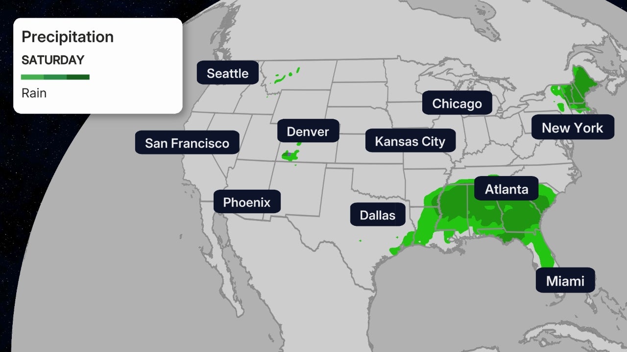
Saturday, rain is most likely across New England, but some showers are also possible in parts of the mid-Atlantic states, Ohio Valley and Appalachians. A rumble of thunder or two might be possible in southern New England.

On Sunday, the chance of rain is highest across parts of northern New England. For now, it's not expected to be a soaking rain where it does fall. Showers may stretch as far south as Pennsylvania, West Virginia and the Smoky Mountains of Tennessee and North Carolina.
On both Saturday and Sunday, evening temperatures will likely be in the 40s and 50s in the Northeast. Across the mid-Atlantic, temperatures will be in the 50s and 60s.
Midwest
Other than some showers in the Ohio Valley and eastern Great Lakes Saturday, the region should be mostly dry this weekend.
Evening temperatures on Saturday are expected to be in the 40s and 50s in the northern Plains and upper Midwest. Saturday evening will be slightly warmer than Halloween night for many, as a cold front is set to push through the region.
Sunday evening, much of the upper Midwest and northern Plains can expect temperatures in the 30s and 40s. Parts of the Great Lakes and Ohio Valley will be slightly warmer, with temperatures in the 50s. Temperatures may fall dramatically during the Sunday night trick-or-treat times from Kansas to Illinois as drier and cooler air sweeps into the region.
Wind speeds will pick up across parts the Great Lakes and Plains as the cold front pushes through, so it will feel a bit colder than what the thermometer reads.

South
Saturday, rain showers are possible across portions of the Tennessee Valley and Appalachians. However, Sunday should be mostly dry from the southern Plains to Florida to the Carolinas.
Saturday and Sunday evenings, areas across the Southeast and Southern Plains can expect temperatures in the 50s and 60s, though parts of Texas and Louisiana may be in the 70s. Low humidity will contribute to comfortable conditions.

West
Saturday, light rain and mountain snow showers are possible in parts of northern California into Oregon and possibly the northern Rockies. Temperatures will likely be in the 40s and 50s across the Pacific Northwest, and in the 60s along the coast of California. Higher elevations could see temperatures in the 30s and 40s.
Sunday, some rain or light snow is possible in parts of Wyoming, northern Colorado, northern Utah and the Nebraska panhandle. Rain will begin to push onshore Sunday night from Northern California into western Oregon.
Temperatures Sunday evening will be in the 40s and 50s in the Pacific Northwest, while much of California will be in the 50s and 60s. Higher elevations of the West will dip into the 30s and 40s during the evening.
The Weather Company’s primary journalistic mission is to report on breaking weather news, the environment and the importance of science to our lives. This story does not necessarily represent the position of our parent company, IBM.
The Weather Company’s primary journalistic mission is to report on breaking weather news, the environment and the importance of science to our lives. This story does not necessarily represent the position of our parent company, IBM.

No comments:
Post a Comment