weather.com meteorologists
Tropical Storm Elsa is soaking Cuba and will then track toward Florida and the coastal Southeast United States, where impacts such as heavy rain, gusty winds and some storm surge are likely.
(MORE: Track Elsa Here | Florida Prepares For the Storm)
Happening Now
Elsa's center is now nearing a landfall in central Cuba as it continues tracking northwest.
Bands of heavy rain and gusty winds are affecting parts of Cuba and the Cayman Islands. More than 5 inches of rain had fallen in at least one location in Jamaica as of late Sunday morning.
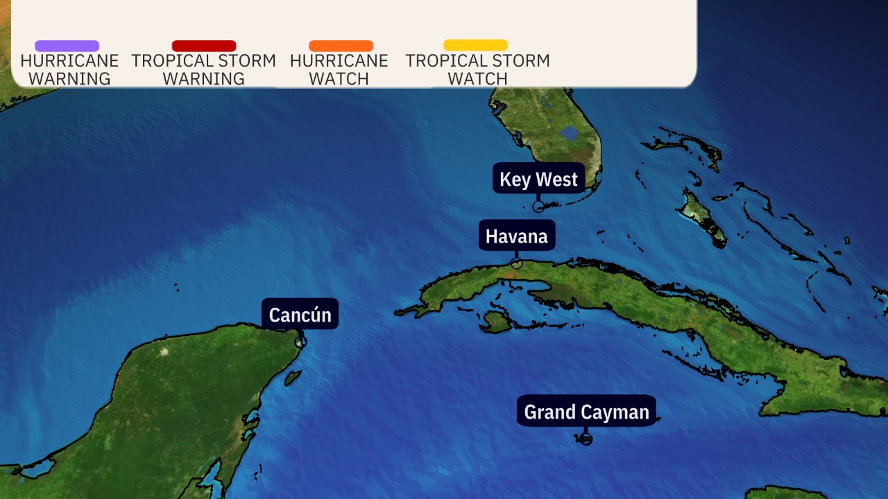
Tropical-storm-force winds are impacting locations in the orange shading on the map below.
 Current Satellite and Wind Field
A tropical storm warning is in effect for portions of the Florida Keys, from Craig Key westward to the Dry Tortugas, and also along the west coast of Florida from Flamingo to Englewood. This includes Key West, Marco Island, Naples, and Sanibel Island. Tropical storm conditions (winds 39+ mph) are expected to begin in these areas tonight.
Tropical storm watches have also been issued in other parts of Florida, from Craig Key eastward to Ocean Reef, including Florida Bay, and from Englewood northward along the west coast to the Aucilla River, including Tampa Bay. These areas could see tropical storm conditions by Tuesday.
Various tropical storm and hurricane watches and warnings remain in effect for the Caribbean, including parts of Cuba and the Cayman Islands. See the map below for more details.
Forecast Path and Intensity
Elsa will gradually turn more to the north-northwest and then the north around the western periphery of a high-pressure system in the western Atlantic.
The storm will first track over Cuba on Monday. Interaction with Cuba should take some toll on its intensity.
Elsa's center will then emerge over the southeast Gulf of Mexico Tuesday.
Gulf of Mexico waters will be plenty warm enough for some reorganization of Elsa after it moves north of Cuba. However, wind shear during this time will likely limit the amount of possible intensification.
Be Prepared For The Storm With These Essentials (SPONSORED)
Elsa's impacts could arrive in southern Florida by later Monday and then spread northward through the state into Tuesday and Wednesday.
Other parts of the Southeast, including the coastal Carolinas and southeast Virginia might see some impacts from Elsa from late Wednesday into Thursday night, but that will depend on how well organized the system is once it recurves northeastward near, inland or offshore from the coast. Elsa or its remnant could then brush parts of southeast New England on Friday.
 Current Status and Forecast Path
Forecast Impacts
In general, most of Elsa's impacts - rain, wind, coastal flooding/surge, tornado threats - should occur along and to the east of the track of Elsa's center.
Below is a breakdown of what we know right now about the expected impacts from Elsa.
Rainfall
Parts of central and western Cuba are expected to pick up 5 to 10 inches of storm-total rainfall, with isolated amounts up to 15 inches. This could lead to dangerous flash flooding and mudslides.
In the Cayman Islands, 3 to 5 inches of rain is expected from Elsa, which could lead to some flash flooding, there.
Parts of the Florida Keys and Florida Peninsula can expect 2 to 4 inches of rain, with locally up to 6 inches possible. This may cause some flash flooding, especially in urban areas.
Additional soaking rain is expected across parts of south and coastal Georgia into the coastal Carolinas and southeast Virginia, however, Elsa will be speeding up as it moves through these areas, so only isolated flash flooding is expected.
 Rainfall Forecast
Wind
Tropical storm conditions (winds 39+ mph) could arrive by tonight in South Florida. Stronger wind gusts could break some tree limbs, down trees and cause scattered power outages.
Gusty winds could then spread northward across the Florida Peninsula through Tuesday and early Wednesday. For now, we expect winds of tropical storm force at most.
 Tropical Storm Wind Chances
Storm Surge
Storm surge inundation is possible near and to the east of where Elsa's circulation center tracks.
The National Hurricane Center (NHC) says storm surge could reach the following levels if peak surge arrives at the time of high tide:
-A storm surge of 2 to 4 feet above ground level is possible along Florida's western coast, from Bonita Beach to the mouth of the Suwannee River, including Tampa Bay. The NHC has issued a storm surge watch for this area.
-A storm surge of 1 to 3 feet above ground level is possible in southwest Florida from Flamingo to Bonita Beach.
-A storm surge of 1 to 2 feet above ground level is possible in the Florida Keys from Ocean Reef to the Dry Tortugas including Florida Bay.
-Southern Cuba could see storm surge raise water levels 3 to 5 feet above normal tide levels.
 Storm Surge Forecast
Tornadoes
Typical of most tropical cyclones, a few tornadoes and waterspouts are also possible in parts of the Florida Peninsula from Monday night into Tuesday night or Wednesday given the potential increase in wind shear.
 Tornado Threat
Elsa Recap
Tropical Depression Five formed last Wednesday night while it was about 1,000 miles east of the Windward Islands.
The system then became Tropical Storm Elsa six hours later on July 1, the earliest forming fifth named Atlantic storm on record in the satellite era (since 1966). The old record was held by Edouard, which developed a year ago on the evening of July 5.
Elsa also formed unusually far south and east for so early in the hurricane season, according to Colorado State University tropical scientist, Phil Klotzbach.

The following morning, Elsa became the first hurricane of the 2021 Atlantic hurricane season on July 2, almost six weeks earlier than the average date of the season's first Atlantic hurricane.
Elsa brought hurricane force gusts to Barbados and St. Lucia Friday morning. A sustained wind of 74 mph and gust of 86 mph was measured on Barbados early Friday. A wind gust of 79 mph was reported in St. Lucia.
The name Elsa is new to the list of rotating names being used this season. This year's list was last used in 2015, but Erika was the "E" storm that year.
Erika was retired after it caused deadly and destructive flooding in the Caribbean Island of Dominica. Elsa replaced it.
The Weather Company’s primary journalistic mission is to report on breaking weather news, the environment and the importance of science to our lives. This story does not necessarily represent the position of our parent company, IBM.
The Weather Company’s primary journalistic mission is to report on breaking weather news, the environment and the importance of science to our lives. This story does not necessarily represent the position of our parent company, IBM.


No comments:
Post a Comment