Chris Dolce
Severe thunderstorms and heavy rainfall will return to parts of the Plains, Midwest and South this weekend as a new storm system tracks across those regions.
Drier, cooler air to the east of the Rockies is providing a temporary break from widespread severe weather. This is happening in the wake of a multi-day episode of severe thunderstorms and flooding rainfall in the South, Midwest and East earlier this week.
But storms will become more common this evening.
Here is the latest radar:

Here's a closer look at the forecast.
Saturday
Scattered severe thunderstorms are expected to develop Saturday evening in the central Plains.
The best chance of these storms will be in eastern Kansas, spreading eastward into western Missouri late. Any storms farther south in Oklahoma and Texas are expected to be isolated.
Large hail and damaging winds are the main threats, but a few tornadoes are also possible. Some very large hail is possible in central or eastern Kansas.
A broad area of developing rain and thunderstorms could spread eastward toward the mid-Mississippi and Ohio valleys on Saturday night with locally heavy rain possible.
 Saturday - Saturday Night's Severe Thunderstorm Forecast
Sunday
Rain and thunderstorms will be ongoing Sunday morning in the Ohio Valley and southern Great Lakes.
Stormy weather will likely expand southward into areas from eastern Texas to the lower Mississippi Valley during the day. In these areas, severe thunderstorms are possible with damaging thunderstorm winds and hail the main threats.
Some hailstones larger than 2 inches in diameter are possible in the ArkLaTex region.
Soaking rainfall might also contribute to some localized flash flooding.
 Sunday - Sunday Night's Severe Thunderstorm Forecast
How Much Rain?
At least an inch of rain is possible this weekend from parts of the Midwest into the lower Mississippi Valley. Some communities might see somewhat higher totals of 2 to 3 inches.
Additional bouts of heavy rain could impact the South through the middle of next week as the front associated with this storm system stalls out. That might contribute to a flooding threat in the region; Check back in the coming days for further details.
 Rainfall Forecast
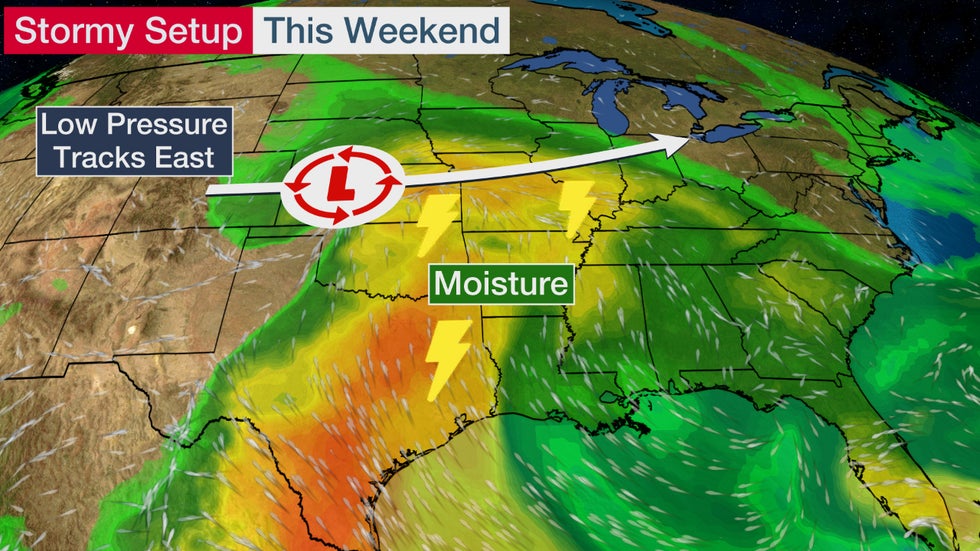
Stormy Setup
A low-pressure system will tap into a modest increase in Gulf of Mexico moisture as it tracks from the Central Plains into the Ohio Valley. Stronger winds out of the south and southwest aloft may give storms just a little spin before they jettison east and south with the jet stream as a line of thunderstorms. A warm front stretching to the east of the center of circulation will provide some extra lift for storms that develop.
This will provide the ingredients needed for a few severe thunderstorms.
After that low pressure system moves through, a stalling front could eventually fuel bouts of heavy rainfall in the South next week.
The Weather Company’s primary journalistic mission is to report on breaking weather news, the environment and the importance of science to our lives. This story does not necessarily represent the position of our parent company, IBM.
The Weather Company’s primary journalistic mission is to report on breaking weather news, the environment and the importance of science to our lives. This story does not necessarily represent the position of our parent company, IBM.


No comments:
Post a Comment