Chris Dolce
A relatively cool weather pattern for mid-April has settled into parts of the central and southern U.S., and while that might bring frustration to those longing for warmer conditions, it also means the month's notorious reputation for large severe weather outbreaks is likely to be off the table well into next week.
Warm, humid air from the Gulf of Mexico is one of the key ingredients for triggering severe weather during spring in the South, Midwest and Plains. Storm systems tracking across the U.S. tap into that moisture, leading to the rise of unstable air and the formation of strong to severe storms.
But a weather pattern change bringing cool temperatures to the central U.S. right now has caused this moisture source to be shunted southward near the immediate Gulf Coast this week.
Shop Great Deals on Women's Activewear (SPONSORED)
While there have been some isolated instances of damaging winds, large hail and flooding from Texas to the Gulf Coast over the past few days, it has not been widespread, and that should continue as the week closes out.
We expect the general April severe weather lull to continue this weekend into at least the first half of the week ahead. That's because high pressure will supply additional intrusions of colder than average air from Canada into the central and southern U.S.
 Forecast Highs Next Tuesday Compared to Average
"Surface high pressure will persist east of the Rockies, and periodic cold frontal intrusions into the Gulf of Mexico will result in a dearth of boundary-layer moisture," NOAA's Storm Prediction Center said in its long-range severe weather outlook issued Thursday morning for the first half of next week.
You can see this in the setup map for early next week below, with shadings of brown representing the absence of moisture in much of the U.S. The exception is the Florida Peninsula, where there will be bouts of stormy weather since the moist air will not be pushed out of the state.
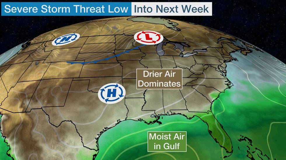 General weather pattern setup next Monday.
Last Friday (April 9) was the most recent day of widespread severe weather in the U.S., with a combined total of 345 reports of damaging winds, large hail and tornadoes in the South. The total number of severe weather reports in the following five days ending Wednesday was less than half that total.
This is a good example of how severe weather in spring can oscillate between more active and less active phases week to week or even month to month.
Update Your Home Office With These Stylish Desks (SPONSORED)
Despite the current lull in widespread severe weather, you should not let your guard down for the rest of spring.
Another weather pattern change late in April or May could quickly flip the switch back on to more favorable conditions for severe storms to produce tornadoes, damaging winds and large hail.
We are monitoring late next week into the following weekend for the possibility of a more active severe weather pattern, but it's too early for any details.
The Weather Company’s primary journalistic mission is to report on breaking weather news, the environment and the importance of science to our lives. This story does not necessarily represent the position of our parent company, IBM.
The Weather Company’s primary journalistic mission is to report on breaking weather news, the environment and the importance of science to our lives. This story does not necessarily represent the position of our parent company, IBM.


No comments:
Post a Comment