Jonathan Erdman
The 2021 Atlantic hurricane season is about six weeks away, but the past six seasons have each gotten off to an early start.
Officially, the Atlantic hurricane season runs from June 1 through November 30. That timeframe was selected to encompass 97% of all Atlantic tropical storms and hurricanes, according to NOAA's Hurricane Research Division.
But what about the other 3%?
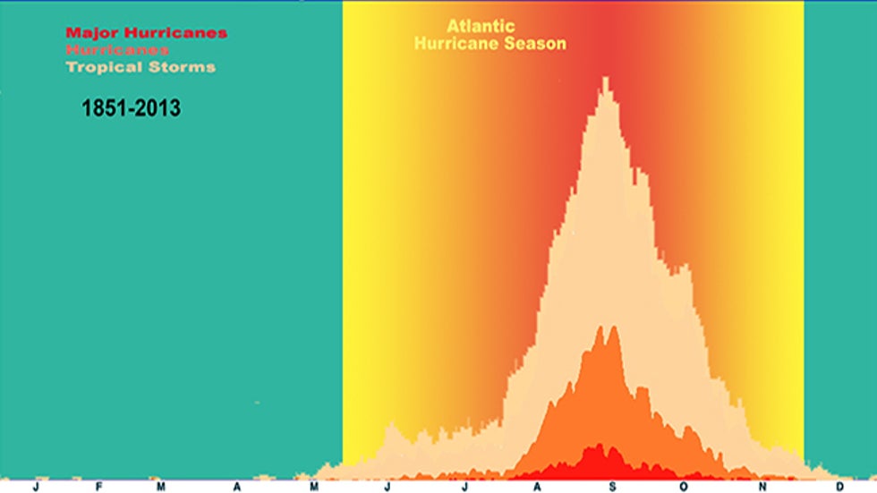 Tropical storms, hurricanes and major hurricanes in the Atlantic Basin, by month, from 1851 to 2013. The June 1 to Nov. 30 hurricane season is highlighted in the warmer colors. A few named storms are shown in other times of year in the teal-colored sections of the graph at left and right.
You can see in the NOAA graph above that a small number of tropical storms, and even hurricanes, have occurred primarily in May and December, but also in every other month outside of hurricane season.
Since 2015, at least one named storm has developed before June 1 each hurricane season, some of which have had impacts in the United States and elsewhere in the Atlantic Basin.
The National Hurricane Center has not yet adjusted the start of hurricane season earlier to account for these pre-season storms. However, beginning this year, they will begin issuing routine Atlantic tropical weather outlooks on May 15, rather than June 1.
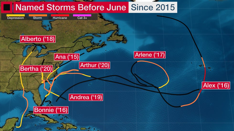 Tracks of all Atlantic named storms that have formed before June 1 in each hurricane season from 2015 through 2020. The black segments of tracks denote when each system was either a remnant low-pressure center or an area of low pressure before becoming a depression or storm.
Last May, the Carolinas were impacted by a pair of tropical storms late in the month.
Tropical Storm Arthur brought soaking rain to far eastern North Carolina as it tracked just off the Southeast coast May 16-19.
That was followed by Tropical Storm Bertha, which made landfall near Isle of Palms, South Carolina, just hours after it formed on May 27. Bertha's impacts were minor, but it did produce gusty winds and locally heavy rainfall.
Subtropical Storm Andrea formed in May 2019 to the southwest of Bermuda the week before Memorial Day, but only lasted about 24 hours.
In 2018, Tropical Storm Alberto made a Memorial Day landfall along the Florida Panhandle, remained intact and took a strange track into Lower Michigan before losing its tropical characteristics.
Tropical Storm Arlene developed even earlier than Alberto and, in 2017, became only the second April Atlantic tropical storm of record.
Perhaps 2016 was the strangest early start to an Atlantic season in recent memory.
Tropical Storm Bonnie soaked the coast of the Carolinas in late-May 2016. But that was preceded by eastern Atlantic Hurricane Alex, only the second known January Atlantic hurricane. Alex eventually made landfall in the Azores as a tropical storm.
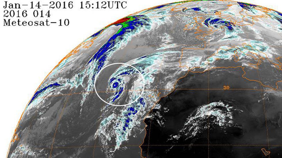 A Meteosat-10 infrared satellite image shows Hurricane Alex (circled) in the eastern Atlantic Ocean on Jan. 14, 2016, at 10:12 a.m. EST.
In 2015, Tropical Storm Ana made the second-earliest U.S. landfall of at least a tropical storm on record on Mother's Day weekend along the coast of the Carolinas.
This early start also happened in 2012 (Alberto, then Beryl in May), 2008 (Arthur), 2007 (another Subtropical Storm Andrea) and 2003 (another Ana, this time in April). Beryl nearly became a hurricane before coming ashore near Jacksonville Beach, Florida, on Memorial Day weekend 2012.
At least one named storm has formed prior to June 1 in 10 of the last 18 years through 2020. There were a total of 13 out-of-season named storms during that time. The majority of these developed and meandered, or made landfall along the coast from North Carolina to northeastern Florida.
Happening for Decades
According to NOAA's database, 40 storms formed in the Atlantic Basin before June 1 from 1851 through 2020, a long-term average of one such early storm every four to five years.
The 2010s had the most such storms, and there has been a steady increase since the 1990s.
The 1950s had six such storms, the 1930s had four and there was another four preseason storm streak from 1887 through 1890.
It's possible there were other such storms in the era before satellites – before the mid-1960s – that were missed by ship observations or reports from areas impacted.
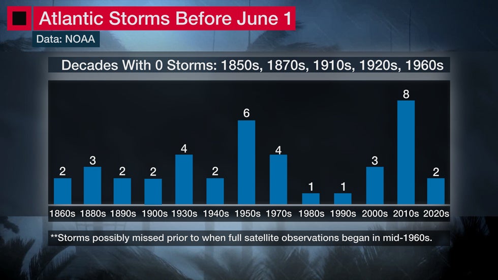 Breakdown of pre-June 1 Atlantic storms by decade. The era where full satellite surveillance of the Atlantic Basin was in place, since the mid-1960s, has the most reliable data.
Does a pre-June 1 start mean an active hurricane season is ahead?
The short answer is not always.
Of the 33 years with an early start to the hurricane season since 1851, only 15 had more named storms than an average season.
Preseason Hurricanes
Before January 2016's oddball Alex, NOAA's database lists seven other Atlantic Basin hurricanes that formed before June 1.
Three of those hurricanes – Able (1951) and unnamed hurricanes in May 1908 and 1889 – made close passes to the East Coast. Alma in 1970 weakened to a tropical depression before gliding across the Southeast.
A 2013 study unearthed a once-forgotten Civil War-era U.S. hurricane landfall in late May of 1863.
Named Amanda in honor of a Union ship driven ashore, this was the only May U.S. hurricane landfall on record. It came ashore in the Florida Panhandle and killed at least 110.
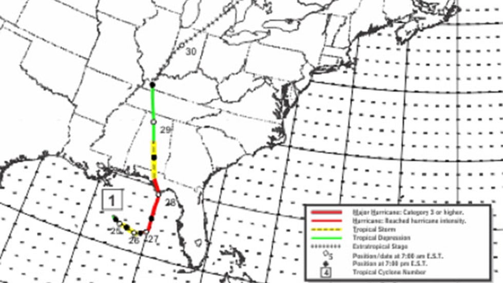 Track history of Hurricane Amanda from May 24-31, 1863, the only known May hurricane landfall in U.S. history.
A bizarre March 1908 hurricane slammed into the Leeward Islands from the north.
How Early-Season Development Happens
Ocean heat content tends to be too marginal to support the development of a tropical storm or hurricane this early in the season.
Wind shear – the change in wind speed and/or direction with height – also tends to be strong before June and can rip apart tropical systems before they can organize.
But low-pressure systems with cold and warm fronts can sometimes stall over the ocean in late spring.
If the ocean water is warm enough, and winds at jet stream level aren't too strong, thundershowers can build and persist around the center of this stalled low, slowly warming the nearby column of air enough to form a subtropical storm, a mix of a tropical storm and one you'd typically see over land areas with warm and cold fronts.
If thunderstorms persist and cluster long enough, a subtropical storm can evolve into a tropical storm, like Alberto in 2018, or even a hurricane, as with Alex in January 2016.
The Weather Company’s primary journalistic mission is to report on breaking weather news, the environment and the importance of science to our lives. This story does not necessarily represent the position of our parent company, IBM.
The Weather Company’s primary journalistic mission is to report on breaking weather news, the environment and the importance of science to our lives. This story does not necessarily represent the position of our parent company, IBM.


No comments:
Post a Comment