Chris Dolce
Severe thunderstorm warnings will have a new look later this spring in order to call more attention to storms that pose a higher-impact threat of destructive winds and large hail. These new warnings could also soon activate emergency alerts on mobile devices.
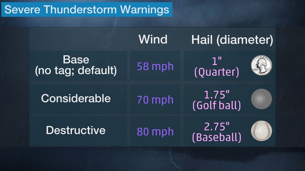
A severe thunderstorm warning is issued by National Weather Service (NWS) when a storm is capable of producing wind gusts of at least 58 mph and/or hail at least 1 inch in diameter. Sometimes these warnings indicate a tornado is also possible.
Severe thunderstorm warnings are commonly issued each year across the United States based on those criteria, especially east of the Rockies, where warm, humid air is often found during the spring and summer. You can see this in the map below, which shows the number of severe thunderstorm warnings each NWS office issued in 2020. In many cases, the number of warnings issued was over 100 per office.
 Severe thunderstorm warnings issued by local NWS forecast offices in 2020.
While all severe thunderstorm warnings should prompt you to take precautions in order to protect life and/or property, a smaller number of them indicate there is a higher-end threat of damaging winds and/or large hail. Beginning on or around April 28, the NWS will tweak how it issues severe thunderstorm warnings so that those higher-impact warnings receive a greater level of attention.
Severe thunderstorm warnings will now be placed in one of three threat level categories, according to a release from NOAA.
SPONSORED: Epic winter clearance sale at Sierra Trading Post
The first warning category will be for a storm (or line of storms) that meets the minimum severe thunderstorm criteria. These warnings will be issued much like they are now.
Warnings for a storm (or line of storms) with a threat of significantly stronger winds and/or large hail will be placed in one of two higher-end categories. These warnings will state the thunderstorm damage threat is either "considerable" or "destructive," based on the minimum wind and/or hail criteria listed below.
This sample severe thunderstorm warning is where you would see enhanced language for a storm categorized as "destructive." The potential for hailstones up to 3 inches in diameter is what triggered the destructive wording in this example.
 Sample severe thunderstorm warning in the destructive category.
The billion-dollar Aug. 10, 2020, Midwest derecho is an example of when the thunderstorm damage threat from high winds would be classified as "destructive" in future warnings. This severe thunderstorm warning from that day in Iowa called for wind gusts up to 90 mph, clearing the 80 mph minimum criteria for that highest category.
Eventually, severe thunderstorm warnings in the "destructive" category will be recommended to activate a Wireless Emergency Alert (WEA) on mobile devices. This will be in addition to several other types of NWS warnings that already trigger a WEA to be activated, including tornado warnings.
The new severe thunderstorm WEA will be implemented on a date to be determined sometime after April 28.
The Weather Company’s primary journalistic mission is to report on breaking weather news, the environment and the importance of science to our lives. This story does not necessarily represent the position of our parent company, IBM.
The Weather Company’s primary journalistic mission is to report on breaking weather news, the environment and the importance of science to our lives. This story does not necessarily represent the position of our parent company, IBM.


No comments:
Post a Comment