Sunday, February 28, 2021

Flooding Rain Inundates Parts of Kentucky, West Virginia; Severe Weather Threat Lingers in South

 Jonathan Erdman

Published: February 28, 2021


Flooding rain and severe thunderstorms are pouding parts of the Ohio Valley and South as February exits with a bang and the calendar turns to March.

Dangerous flash flooding has already occurred in parts of the Ohio Valley and Appalachians, particularly in parts of Kentucky and West Virginia.

Widespread flooding, including flooding of homes and businesses and major highways, was reported in Murray, Kentucky, near the Tennessee state line about 90 miles west-northwest of Nashville.

Flooding in Todd County, Kentucky, prompted evacuations of several homes in the town of Elkton, where water was reportedly up to and under some structures. A rare flash flood emergency issued by the National Weather Service for this area.

A section of road was washed out in Graves County. At least one vehicle was trapped on a flooded street in Hopkinsville. A high school softball field was flooded in Booneville.

In West Virginia, a reservoir near the town of Hurricane overflowed onto Highway 34, roughly halfway between Charleston and Huntington. One motorist was rescued after driving into a flooded road near the town.

Water entered several homes and some secondary roads began to wash out in Pennsboro, West Virginia. Roads were blocked by up to 3 feet of water in Mineral County. Deckers Creek in Morgantown flooded a road Sunday afternoon.

A swift water rescue was reported south of Huntington, West Virginia, and at least one street was flooded in the city of Huntington.

Numerous roads were closed due to high water in Switzerland County, Indiana, and Pike County, Ohio.

Over 100 reports of flash flooding were received by the National Weather Service Sunday from Kentucky to western Maryland.

Article image

Meanwhile, severe thunderstorms flared up late Sunday morning in parts of the South. Hail up to ping-pong ball size was reported in Grayson County, Texas.

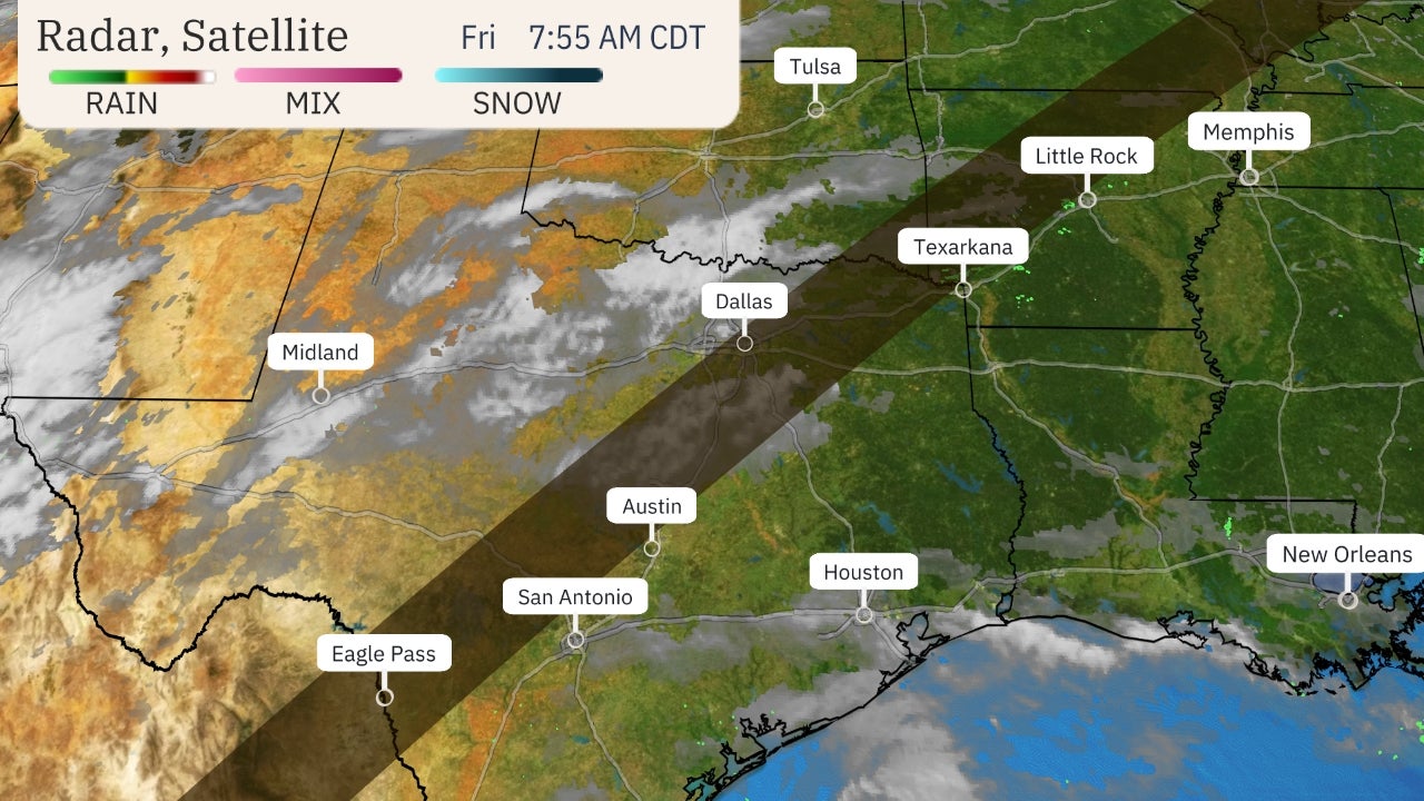
The map below shows the current active flash flood warnings, severe thunderstorm and tornado watches and warnings.

Article imageCurrent Radar, Severe Weather Watches and Warnings

Deep moisture ahead of an advancing cold front and jet-stream energy are all teaming up to produce this double threat of flooding and severe thunderstorms through early Monday morning.

(MORE: March Weather Has a Stormy Reputation)

Let's take a closer look at each threat.

Flood Threat

The heaviest additional rain will fall through Monday morning in parts of Kentucky, West Virginia, Tennessee, Arkansas, northern Louisiana, northern Mississippi and northern Alabama. Some of these areas may pick up an additional 3 inches of rain or more.

Article imageRainfall Outlook

This additional rain, on top of what has already fallen, is likely to trigger additional flash flooding, particularly in hilly terrain, as well as minor, moderate and locally major river flooding.

The National Weather Service has issued flood watches from the lower Mississippi Valley to the Appalachians.

Article image

NOAA's Weather Prediction Center issued a moderate risk of excessive rainfall - their second highest risk level - through early Monday morning in much of Kentucky, northern Tennessee and parts of West Virginia.

According to NOAA, atmospheric moisture values - what meteorologists call precipitable water - were near record values for late February in the Ohio Valley, two to three times the average.

Another concern, according to the NWS Ohio River Forecast Center, was in the Appalachians, where rain and warmer temperatures were expected to melt a significant fraction of existing snowpack from eastern West Virginia into southwest Pennsylvania.

Never drive through flooded roads. Over half of all flood-related fatalities occur in vehicles.

By Monday, a cold front will dry out the Ohio Valley and Appalachians, but areas of locally heavy rain could linger in the South through Wednesday as another wave of low pressure forms along the east-to-west oriented frontal boundary in the Deep South.

(MAPS: 7-Day Forecast)

Severe Threat

There is also a threat of severe thunderstorms on the table through early Monday morning.

Humid air by end of February standards, with dew points in the mid-60s, is in place from Texas to the Tennessee Valley. With an active jet stream providing wind shear, the stage is set for at least some severe weather in parts of the South.

Scattered severe thunderstorms are expected from parts of northeast Texas into southeast Oklahoma, Arkansas, northern Louisiana, northern Mississippi, Tennessee, northern Alabama and southern Kentucky.

Damaging thunderstorm winds and a few tornadoes are possible in these areas. Some large hail is also possible.

(MORE: Will La NiƱa Trigger a Dangerous Severe Weather Season)

Article image
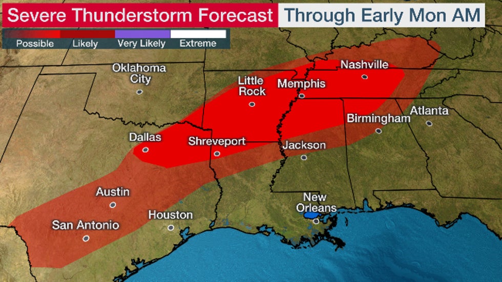
Severe Thunderstorm Forecast

While thunderstorms are possible in the Deep South Monday and Tuesday, the severe weather threat those days appears to be minimal.

Make sure you have multiple ways of receiving severe weather alerts that can wake you up at night, including your smartphone and NOAA weather radio. Make sure your smartphone is charged and alerts are turned on.

These alerts could provide the precious minutes needed to move quickly to shelter and could save your life.

We have already had two deadly tornadoes in the South so far in 2021 that did not occur in large severe weather outbreaks. Both also occurred at night.

The Weather Company’s primary journalistic mission is to report on breaking weather news, the environment and the importance of science to our lives. This story does not necessarily represent the position of our parent company, IBM.

The Weather Company’s primary journalistic mission is to report on breaking weather news, the environment and the importance of science to our lives. This story does not necessarily represent the position of our parent company, IBM.

'Meteorological Spring' Arrives Monday. Here's What That Means and Why It's Different Than the Equinox

 Jonathan Erdman

Published: February 28, 2021


Meteorological spring arrives Monday and while you may be itchy for warmer weather, you may wonder why this is happening weeks before the vernal equinox.

After a stretch of record-smashing cold and repeated rounds of snow in February, spring couldn't come soon enough for those impacted by crippling power and water outages in Texas and surrounding states.

It turns out, spring is already here, at least according to meteorologists.

The arrival of spring you've probably heard about before is known as the vernal equinox.

That's the moment in time when the sun's most direct rays are shining on the equator. In 2021, the vernal equinox will occur on Saturday, March 20, at 5:37 a.m. EDT. If you're an early rise on a weekend morning, you can observe that this year.

Its counterpart in fall, the autumnal equinox, and also the summer and winter solstices, all occur in late September, June and December, respectively, due to the tilt of the Earth's axis as it revolves around the sun.

This changing sun angle through the year is why we have so-called astronomical seasons.

(MORE: March Temperature Outlook)

Article imageThe orientation of the Earth relative to the sun at the northern hemisphere's vernal (spring) equinox, summer solstice, autumnal equinox and winter solstice.

Why do meteorologists stray from those seemingly concrete definitions?

It all has to do with temperatures.

When you examine average daily high and low temperatures through the year, you'll quickly notice a pattern.

The coldest three months of the year in the Northern Hemisphere are usually from the beginning of December through the end of February, while the warmest three months are typically from the beginning of June through the end of August.

These nice, clean, three-month buckets are known as meteorological winter and summer, respectively.

And these clean three-month temperature buckets don't line up nearly as well with the astronomical seasons, for example late December through late March.

Article imageA generic, sample trace of average high (red) and low (blue) daily temperatures the year. The coldest three months of the year are known as meteorological winter. The hottest such three months are meteorological summer. The transition between those two are meteorological spring and fall.

In fact, Alaska-based climatologist Brian Brettschneider calculated that the Dec. 1 - Feb. 28 meteorological winter is a better fit to the coldest time of year in most of the United States and Canada.

In an analysis of dozens of U.S. cities, Brettschneider found only Honolulu, Hawaii, had its coldest 90-day stretch extend deep into March.

For those that live in the northern U.S., this makes sense.

It seems a little silly when we say "winter is here" just days before Christmas, when many parts of the north have already had at least one significant snowfall or cold snap.

Meteorological spring - March 1 through May 31 - is the transition between the three coldest and three warmest months of the year.

Another advantage to meteorological seasons is the ease of calculating seasonal statistics, since every meteorological season starts on the first of the month.

A March of Increasing Daylight, Temperatures

Most of the U.S. will pick up a full hour of evening daylight when daylight saving time arrives on March 14.

Even if there wasn't daylight saving time, most areas in the northern U.S. would gain an extra 30-45 minutes of sunlight in the evening by the end of March. More southern locales would typically only pick up 15 to 30 minutes of additional evening daylight during the month, if our clocks didn't spring forward.

Article imageSunset times on March 1 (prior to daylight saving time) and March 31 (after daylight saving time) in 2021 for various U.S. cities.

While March has a well-earned stormy reputation, including winter storms in the West and northern U.S., with the sun gradually shining higher in the sky, average high temperatures typically rise about 10 degrees in the Midwest, Northeast and Plains by month's end.

(MORE: When to Expect the First 70s and 80s of Spring Where You Live)

Article imageDaily average high temperatures on March 1 and March 31 in several U.S. cities. The largest change in temperatures during the month occur in the northern U.S., particularly the Plains and Midwest.

The Weather Company’s primary journalistic mission is to report on breaking weather news, the environment and the importance of science to our lives. This story does not necessarily represent the position of our parent company, IBM.

The Weather Company’s primary journalistic mission is to report on breaking weather news, the environment and the importance of science to our lives. This story does not necessarily represent the position of our parent company, IBM.

Atlantic Hurricane Season to Start Earlier? NOAA Is Considering It

 Jan Wesner Childs

Published: February 26, 2021


NOAA is considering moving up the official start date of the Atlantic hurricane season, after a string of years when the first named storm in the basin has happened before June 1.

A team from the National Hurricane Center and the National Weather Service will likely take up the topic this spring, NHC spokesperson and meteorologist Dennis Feltgen confirmed in an email to weather.com Friday.

A recommendation was made at the most recent NOAA Hurricane Conference in December that the team be assembled this year to discuss the idea, Feltgen said in a statement.

"Considerations for the team would include a determination of the quantitative threshold for adding or removing dates from the official Atlantic hurricane season," he said. "Then, an examination would need to take place regarding the need for, and potential ramifications of, potentially moving the beginning of the hurricane season to May 15."

(MORE: We're Less Than 100 Days From the 2021 Atlantic Hurricane Season – Here Are This Year's Names)

Currently, the Atlantic hurricane season officially runs from June 1 to Nov. 30. The original dates were set in 1935 when a new hurricane warning network was set up with a special telegraph line that operated from June 15 to Nov. 15, according to NOAA. Those dates were changed in 1965 to coincide with the first and last days of the month. They've remained the same ever since.

Meanwhile, the unofficial kickoff of the season has moved up.

Tropical Storm Arthur formed last year on May 16, marking the sixth consecutive year that a named storm formed before June 1. Prior to that, at least one named storm had developed before June 1 each hurricane season since 2015, some of which had impacts in the United States and elsewhere in the Atlantic Basin. In fact, tropical storms have occurred in every month of the year.

Any change in dates would affect only the Atlantic hurricane season and would put it in line with the Eastern Pacific hurricane season.

Earlier named storms are the topic of much research, especially as they might relate to climate change. Hurricanes are fueled by warmer ocean temperatures and most often occur in the summer to late fall.

Article image

The fact that storms are being identified at different times of the year is often attributed to better technology, including high-definition satellites.

"Named storms have formed prior to the official start of the hurricane season in about half of the past 10-15 years, including each of the past six years," Feltgen said. "Many of the May systems are short-lived, hybrid (subtropical) systems that are now being identified because of better monitoring and policy changes that now name subtropical storms."

The NHC has already decided on one change this year that signals a transition toward earlier storm monitoring. The agency will begin issuing its familiar Tropical Weather Outlooks, which provide the probability of tropical cyclone formation during the next 2 and 5 days, on May 15.

The NHC issued 36 "special" TWOs before June 1 last year, according to Feltgen.

Hurricane season dates are important not just to forecasters, but also to emergency management officials who use the dates for planning purposes and public awareness campaigns.

Last year turned out to be a historic hurricane season, with a record 12 named storms making landfall in the U.S.

Article imageThe National Hurricane Center recently released names for the 2021 Atlantic hurricane season.

The Weather Company’s primary journalistic mission is to report on breaking weather news, the environment and the importance of science to our lives. This story does not necessarily represent the position of our parent company, IBM.

The Weather Company’s primary journalistic mission is to report on breaking weather news, the environment and the importance of science to our lives. This story does not necessarily represent the position of our parent company, IBM.


The chameleon month of March

 Updated Feb. 27, 2021 3:02 PM EST

The ground is still white, but the sky was gray in the middle of Pennsylvania and the many other areas on Saturday morning:

The satellite view shows a river of moisture stretching from the Pacific to the Atlantic:

Remarkably, there wasn't excessive precipitation despite the amount of cloud cover. There was wintry precipitation across New England. The cloud area thinned over Kentucky and Tennessee then thickened in the area from Arkansas southwest through Texas.

The surface analysis shows a number of high and low pressure areas, but missing is any place with a strong northerly flow.

The rather weak storm that affected the Northeast on Saturday is getting ready to move off the coast Saturday afternoon. However, as the next map shows, another area of precipitation will be on the way later Saturday night:

This second disturbance has rather heavy rain with it, but will not extend as far north as the previous storm did. However, as succeeding maps show, a low pressure area on the 1 p.m. Sunday map centered over northern Lake Michigan sends precipitation across New England Monday, so there will be some snow as colder air moves into that region.

The batch of rain that extended from southern Indiana to New Jersey on a Sunday afternoon forecast map appears to race off the coast but is quickly followed by another round of rain from the southwest as shown here on the forecast map for 1 a.m. Monday. On this map, you can also see the snow breaking out associated with a low pressure area from Lake Michigan.

A fresh mass of cold air will move southward behind the area of rain and take over the Northeast during Monday afternoon and Monday night.

The next map shows the GFS predicted rainfall between 7 a.m. Saturday and p.m. Monday. The very heaviest rain, more than 2 inches, occurs in an area that currently has much less snow than places to the north. If the entire Northeast experienced a bigger warmup during this time and received the same amount of rain as the Ohio and Tennessee valleys, we'd be looking at a major flood situation. Fortunately, it does not look like that situation will develop in this case.

The map for Tuesday afternoon shows a bitterly cold flow across New England, but a southwesterly flow of warmer air will move across the Plains toward the Great Lakes.

Wednesday looks like a dry day. It'll feel springlike from Des Moines to Pittsburgh in the afternoon, and the cold will ease in New England.

Later next week, it looks like there will be some renewal of the cold in the Northeast as a new high pressure moves in well to the south and a major storm develops.

This forecast map for next Friday shows that storm moving northeastward into the Carolinas. Such a storm could cause a blizzard if it came all the way up the East Coast!

However, at the moment, it looks like substantial snow could occur in parts of the area from eastern North Carolina to southern New Jersey with drier air holding for the north. Realize we're now talking about things a week in advance and one aspect that makes today's forecasting efforts so interesting is that from this far out, details are likely to change.

MARCH

This is the chameleon month of March.  Always searching for a sense of identity, its days stagger through punches of waning winter, dance with the sunlit caresses of coming spring, and hide behind thick clouds through the windswept battles between the two. The midday sky looks brighter now, but the sun sneaks out of view before the dinner dishes can be cleared.  Winter's cloak of white melts down to oozing mud and rushing streams.  The crocus and daffodil bravely blos­som, but wiser plants bide their time til a less treasonous season.

Dark December no longer holds the keys around here, and the door to win­ter's dungeon creaks open. And, yet, rather than seizing this moment of weakness, rather than racing headlong into warmer times, spring prefers the test-market ap­proach: try a hint of south wind here, a puffy cumulus there; teasing breezings be­tween the freezings. Even the south wind has ragged, chilly edges on many a March day; subtle hints of warmth vanish all too quickly in the gathering dim of dusk.

Like a 12-year-old on Saturday morning, March is full of hope.  But Mother Nature and Old Man Winter rule the household.  One day, with ice water in its veins, the northwest wind blasts in from the still frozen hinterlands of the Arctic north. 

And if the south wind does quicken, there's usually an instigating storm waiting in the wings, a two-faced wanderer of the westerlies dealing dreadful thun­derstorms on its south side and freezing gales with drifting snows to its north. As storms approach, the day carries a hint of mildness, but the fading sun gives ground to a milky veil that would all too readily drop snow but for the want of a few de­grees.

And through it all, we mortals whose days are most surely numbered some­how yet yearn for them to pass ... so sweet the lure of prospective spring  ... its meadows splashed with gold, its captivating sunshine, its renewal of earthly life. This year, the continued rollout of the vaccine in spring adds hope.

The set changes each March, and the players follow different scripts. But no matter how many times we see it in life, we are always eager to see it again.

Siberian cold outbreak shatters thousands of records

 Updated Feb. 27, 2021 5:42 PM EST

The Arctic outbreak I blogged about for Valentine's Day extended for another week and is now being called a Siberian cold outbreak after temperatures as low as 50 degrees below zero, that could cause $50 billion in economic impact. It brought repeated ice and snow from Seattle to Texas, then up to Maine. It was so large and impactful, it's a challenge to describe succinctly. Here are some highlights:

It started with warnings covering the nation and models showing low temperatures off the charts for the Central U.S. The cold air plunged temperatures to as low as 50 degrees below zero in Minnesota, while Oklahoma *averaged* just below zero degrees.

Local storm reports: Feb. 11 through Feb. 18, 2021.

From Feb. 11 to Feb. 18, there were over 13,000 snow Local Storm Reports issued to NWS offices, along with nearly 3,000 freezing rain, ice storm and sleet reports. There were also 758 extreme cold reports, 700 high winds reports as well as everything else from mudslides to lightning to tornadoes -- including an EF2 in Georgia and a deadly EF3 in North Carolina!

With nothing to treat the roads or move the snow, much of Texas and Louisiana were snowed in. Freezing rain fell down to the U.S. Mexico border at Texas' most southern points, including Brownsville.

Snow in Austin, Texas, Feb. 16.

The storm spotter reports shown above illustrate that this was a truly cross-country storm. Reports touched every corner of the country from coast to coast: Seattle, San Diego, Brownsville, Texas, Miami, Florida, and northern Maine. The only state untouched was North Dakota, but even they had a few record-low temperatures there. Speaking of record temperatures...

NCDC: Low temperature records: Feb. 9 through Feb. 20, 2021.

NCDC says there were over 8,900 daily record-low minimums and maximums (those are record cold afternoons) set or tied between Feb. 9 and Feb. 20. Four days in the middle set more than 1,000 daily low temperature records.

Unofficially, I can say this is the biggest cold outbreak I've seen in my last 16 years of blogging (NCDC only allows 1,000 records to be plotted at one time, so I can't show you a map of those, but trust me, it would be impressive.) In addition, there were about 3,000 snow records set as well.

NCDC snow records Feb. 9 through Feb. 19, 2021.

The snow records happened as multiple powerful winter storms swept across the country. One hundred and three stations set or tied all-time records -- they had never seen that much snowfall or snow depth (snow on the ground). Another 324 stations did the same for the month of February.

At one point, 73% of the U.S. was covered in snow, the greatest extent in NOHRSC database, which began in 2003. Only South Carolina, Georgia, and Florida were without it.

More than 5.6 million customers were without power at the peak of the cold snap, when many of the record-low temperatures were occurring.

As the cold air froze most power equipment in the state, the entire state of Texas dealt with rolling blackouts, and some were without power for more than a week.

If you want to see how the first few days played out, you can read our Live Blog from Feb. 15-18.


Man missing at sea for nearly 2 weeks found alive in life raft off Washington coast

  One of two men missing at sea for nearly two weeks was found alive on Thursday by a Canadian fishing boat in a life raft in Canadian water...