Jonathan Erdman
A weather pattern change in the West will deliver rain and mountain snow not just for the waterlogged Northwest, but also for drought-suffering California, the Desert Southwest and Rockies into next week.
Earlier this week, high winds blasted California's Sierra, the Bay Area and Southern California, downing trees, blowing over semis, knocking out power to hundreds of thousands and fanning wildfires in what is typically one of the state's wettest months of the year.
The prior week, a powerhouse storm fueled by deep moisture from an atmospheric river triggered a destructive landslide in Oregon and knocked out power to over 600,000 homes and businesses in the Pacific Northwest.
SPONSORED: Epic winter clearance sale at Sierra Trading Post
But this upcoming pattern change is more of a good-news weather story for the West.
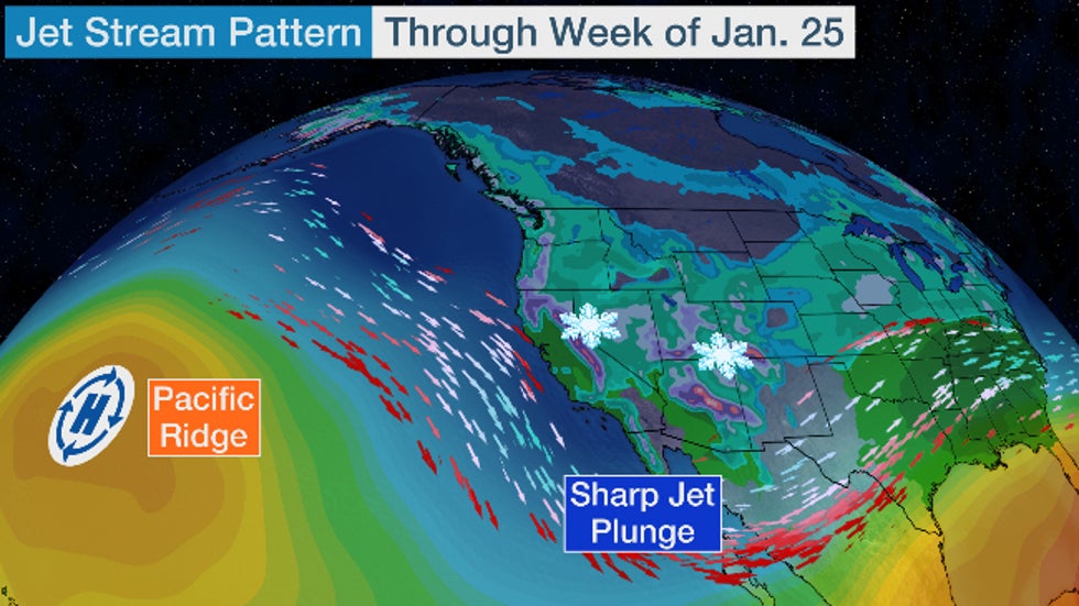
The jet stream will take a sharp, southward nosedive near the West Coast, in response to a warm dome of high pressure aloft poking north toward Alaska's Aleutian Islands.
(MORE: February and Early Spring Outlook)
This U-shaped jet stream trough may hold for a while and will guide a series of Pacific frontal systems into the West Coast over the next week or so.
Computer forecast models suggest there could be four such Pacific storms targeting the West Coast through the final weekend of January.
The first weaker system is moving through the Southwest now with rain in Southern California and snow from the Sierra to the Rockies.
Here's the rough timing of each storm system along the West Coast:
1. Through Saturday (mostly minor)
2. Sunday - Monday (a bit wetter, snowier than the first)
3. Tuesday - Friday (wettest, snowiest, windiest storm)
4. Friday into next weekend (perhaps not quite as windy, wet as No. 3)

That may sound ominous, but here's where the good news comes in.
These storm systems will be coming from the Gulf of Alaska rather than the central Pacific. Therefore, they won't be able to tap nearly as strong and deep a plume of moisture – known as an atmospheric river – as what occurred in the Pacific Northwest earlier this month.
This Gulf of Alaska origin also means these storm systems will be colder.
So instead of widespread heavy rain – including rain falling at higher elevations, leading to lowland flooding and eroding mountain snowpack, as we had in the Pacific Northwest earlier – the net effect of these storms will build mountain snowpack while bringing some rain to lower elevations.

Yes, there could be local flash flooding, including some debris flows over hardened soil recently charred by wildfires.
And, yes, there could be snow falling at lower elevations than usual in the high country, which could lead to travel problems in areas such as the Grapevine north of L.A., the Sierra crest, and Interstate 40 in northern Arizona.
One additional concern may evolve late in the week ahead in the Sierra Nevada, where feet upon feet of snow may pile up. This may elevate avalanche and travel concerns.
But this pattern may be as close to a "Goldilocks scenario" for the West as it can get. Let's explain why.
How to Fight a Drought
Drought is currently widespread through much of the West.
According to the most recent Drought Monitor analysis, a large part of the Southwest, extending into Oregon and California, is in extreme or exceptional drought, the two highest categories.
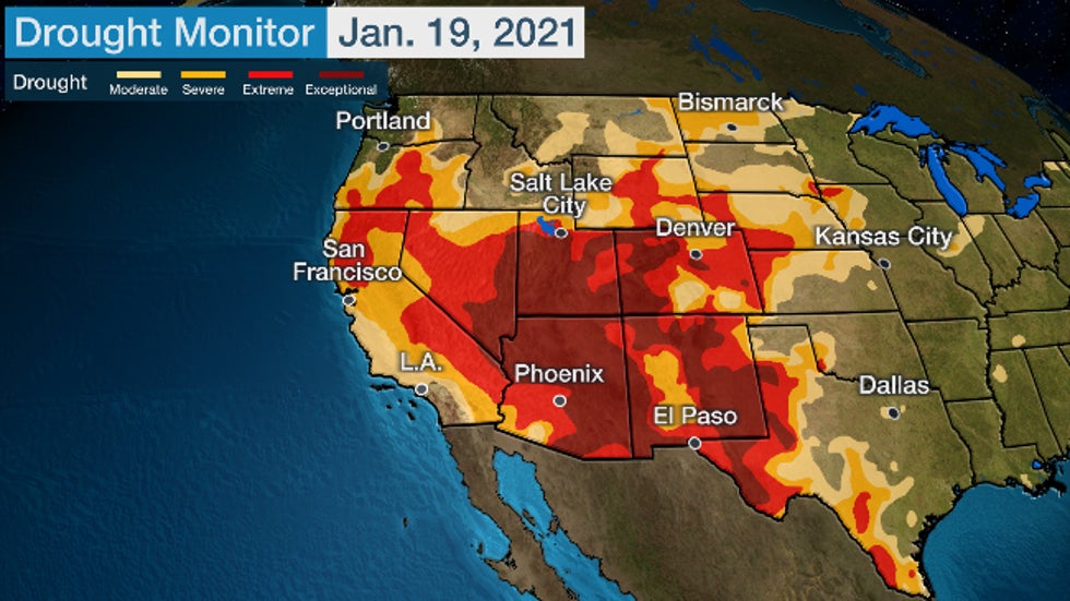 Drought Monitor analysis as of Jan. 19, 2021. Areas in the darkest shading are in the highest level of drought – "exceptional."
The lack of rain during the summer wet phase of the monsoon contributed to the severity of the Desert Southwest drought.
But winter precipitation has also been underwhelming in the drought area.
Through Jan. 20, it's been the second-driest start to winter (since Dec. 1) on record in Salt Lake City with less than a half-inch total precipitation, and the sixth-driest start in San Francisco (SFO Airport).
Mountain snowpack, critical for water supply in parts of the West when it melts in spring and replenishes rivers and reservoirs, has suffered.
According to the USDA's National Resources Conservation Service, the Western snowpack is far below average for this time of year in much of the West, except for the Washington Cascades, Montana, northern Idaho and parts of northwest Wyoming.
In California, the snow water equivalent, a proxy measure for snowpack, is only 40% of average for this time of year, according to the California Department of Water Resources.
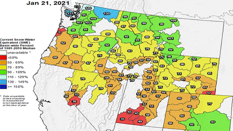 Snowpack percent of average, as measured by snow water equivalent, on Jan. 21, 2021. Much of the Western snowpack was well below average for late January.
While a couple of reservoirs are near average levels in central California, most major reservoirs in the state are notably lower than their average for this time of year.
So this wetter pattern in the West is good news, both to add moisture to dry soil and to add critical snowpack. It may be more beneficial rather than hazardous.
We'll see if this pattern can persist into spring and gradually erode this widespread, serious drought.
The Weather Company’s primary journalistic mission is to report on breaking weather news, the environment and the importance of science to our lives. This story does not necessarily represent the position of our parent company, IBM.
The Weather Company’s primary journalistic mission is to report on breaking weather news, the environment and the importance of science to our lives. This story does not necessarily represent the position of our parent company, IBM.


No comments:
Post a Comment