Chris Dolce
A new snowmaker could spread from California and the Southwest into the Midwest and mid-Atlantic through the week ahead.
We are already tracking one winter storm, named Nathaniel by The Weather Channel, in the Midwest and Northeast early this week. The next system will follow quickly on its heels as it moves from California and the Southwest on Monday to the Midwest and mid-Atlantic Wednesday into Thursday.
Significant snowfall is likely from this system through Tuesday at very low elevations in California and the Southwest. Even the Las Vegas, Nevada, metro area could see some snowfall.
SPONSORED: Epic winter sale at Sierra Trading Post
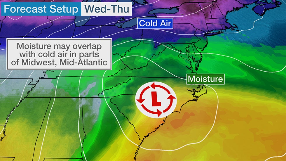
For the Midwest and mid-Atlantic, it's still uncertain how much moisture from this low-pressure system will wrap into the colder air to the north of its track, as depicted in the setup map below. At this time, forecast guidance indicates this will be at most a light snowfall event for these regions, but we will continue to monitor for any changes.
After this system moves over the western Atlantic waters on Thursday, it will turn into a powerful ocean storm that generates huge waves as it tracks farther out to sea.
Here's a general look at what to expect, but be sure to check back to weather.com for updates over the next few days.
Forecast
Monday-Tuesday
This next system will spread from California into the Southwest through Tuesday. Rain will be mostly light in the lower elevations as snowfall piles up from the Sierra Nevada and the mountains of Southern California into the Four Corners.
Snow levels will be very low given the cold origin of this system. That means travel could be impacted in Southern California passes like Interstate 5 through the Grapevine, Interstate 15 through Cajon Pass and Interstate 8 between Viejas and Boulevard.
A dusting of snow could even coat parts of the Las Vegas, Nevada, metro area. Flagstaff, Arizona, is likely to pick up well over a foot of snow.
 Snow and Rain Forecast
Tuesday Night - Wednesday
Light snowfall from this system will spread from parts of Kansas and Nebraska on Tuesday night into the Ozarks, Ohio Valley and parts of northern Tennessee by Wednesday.
St. Louis, Louisville, Kentucky, and Cincinnati are among the cities that might see some light accumulating snow.
 Wednesday's Forecast
Wednesday Night-Early Thursday
Snow could then move eastward into the Central Appalachians and southern mid-Atlantic Wednesday night into early Thursday.
It's uncertain how much snow this system will produce in the mid-Atlantic. As mention earlier, that will depend on how much moisture from this system wraps into the colder air to the north of where it tracks.
Right now, it appears any snowfall in these areas will be on the lighter side since the overlap between moisture and cold air is limited.
Here is a general look at what areas could see light snowfall or a mix of rain and snow Wednesday night into early Thursday.
 Wednesday Night's Forecast
The Weather Company’s primary journalistic mission is to report on breaking weather news, the environment and the importance of science to our lives. This story does not necessarily represent the position of our parent company, IBM.
The Weather Company’s primary journalistic mission is to report on breaking weather news, the environment and the importance of science to our lives. This story does not necessarily represent the position of our parent company, IBM.


No comments:
Post a Comment